sketchucation logo sketchucation
    • Login
    1. Home
    2. bjornkn
    3. Posts
    πŸ›£οΈ Road Profile Builder | Generate roads, curbs and pavements easily Download
    B
    Offline
    • Profile
    • Following 0
    • Followers 0
    • Topics 12
    • Posts 350
    • Groups 1

    Posts

    Recent Best Controversial
    • RE: Large Terrain Mesh

      @dbwv69 said:

      While the primary purpose of the terrain will be to display various scenes from the area, it will also be used to show mining and other activity which requires that some level of detail remain in tact. The mountains do not have to have much detail, other than the general shape, but the lower elevations absolutely must have crisp boundaries because of the proximity of homes, roads, streams, and railroad lines, all tightly packed in among the mountains. You would have to see the area up close to understand fully because satellite images just don't do it justice.

      Drawing an area of this size by hand is not a task that I would want to even contemplate doing. Especially with the terrain involved.

      Do you really have any choice? Even though DE may do a good job reducing the mes it will not add any detail where there is none. Neither will it use different rules in selected areas (my version doesn't anyway).
      Have you actually tried the GP/Triangulate method? It is actually quite fast, and allows you to add detail exactly where you need it, and it allows you to add some edges/creases where there are only ssoft dunes in the dxf mesh.
      Like on this little 100 faces patch elevated 50cm to make it visible entirely above the ground. 5mins?Clipboard-4.jpg

      posted in SketchUp Discussions
      B
      bjornkn
    • RE: Large Terrain Mesh

      Thanks for the coordinates.
      After having a look I'm even more confused why you insist on having all the details in the mountains, with ridge lines etc, when they are not visible at all because of all the trees?
      The perceived landscape is even much smoother in the hilly areas than on my simplified versions. Not only will a more detailed version contain way too many faces, but it will also look wrong because you should really "model" the forests instead of the ground below, as it isn't visible anyway.
      And at the same time you have the ground level with Lidar clutter, too little details and too smoothed. I think you'd be much better off with making this by hand. That way you may even end up with a full model that is managable in SU πŸ˜‰

      posted in SketchUp Discussions
      B
      bjornkn
    • RE: Large Terrain Mesh

      @dbwv69 said:

      The first example (hand sketch) you posted reminds me of an idea that I had originally considered, where I thought about "tracing" over the grouped contour lines to capture all the major details (shape) of the mountains. After some brief experimentation, I quickly discovered that it would have taken forever to do because I wish to maintain as much detail as possible in the lower elevations and especially in the stream beds. It is still an interesting notion, however.

      The amount of detail is entirely up to you, with full control, and would not take forever. Took about 10-15 min to place ~1400 guide points on the rightmost terrain.
      I think you get a bit blinded by the massive amount of data in the mesh, and think that it must be precisely like that in real life. But in reality it shows a smoothed version (3x3m) of the terrain that looks like it's covered in fine sand or snow when you get close - no crisp details. It's like a heavily blurred photo. A real terrain doesn't look like that at all in the details.
      Here's a "stream" in a flat terrain, 15m wide and 3m deep with vertical sides - 15 faces.
      On the right side is a "gridded" version with 3x3m resolution (using Terrain Reshaper - free) and ~8000 faces!
      Doesn't look much like the "real" terrain, even though it has "much more detail"?
      grid3x3.jpg

      Do you have a photo of the area? Ground level? The shapes indicates that there must be lots of boulders, rocks, gravel everywhere?
      Where is it?

      BTW, Solo wrote that he used Deep Exploration, which costs $400-$700 per year πŸ˜‰
      Nice program though. I have an older version of the CAD/expensive version, bought when it was much cheaper and with no annual fees. No skp, Collada, FBX though.

      posted in SketchUp Discussions
      B
      bjornkn
    • RE: Large Terrain Mesh

      @dbwv69 said:

      That's probably a good idea because debating "free" v/s "paid" isn't doing a thing to help me achieve my goal. BTW: Did I detect a note of sarcasm there?
      I'm afraid I couldn't hide it completely πŸ˜‰
      Nevertheless I couldn't resist wasting another hour+ on this terrain after you posted that "little" dxf detail.
      All free tools (I think there are free guide point tools? Although I did use the one in Amorph) πŸ˜‰
      I will not post the Amorph version... It didn't have a chance trying to polyreduce that beast of a terrain in any reasonable amount of time, but could easily build a terrain on top of the dxf.
      dxfterrs.jpg

      posted in SketchUp Discussions
      B
      bjornkn
    • RE: Large Terrain Mesh

      @dbwv69 said:

      I had no idea if you were the one who made the plugin or not but after your having mentioned it several times, even after I made it clear that I wanted to seek free alternatives, it certainly began to look like you either had an agenda or were affiliated in some way.
      My agenda is just to use the right tool for the job.
      @unknownuser said:

      My problem is somewhat unique and as a direct result, it requires creative and innovative solutions. Fortunately, there are no deadlines so I can spend as much time as I like while trying to find an adequate solution.

      Not more unique than that we all have to face it all the time when making models in SU, and particularly terrains.

      @unknownuser said:

      How do you think that all these nifty plugins and addons for Sketchup were created in the first place? Quite simply, because someone took the time to do the hard work while trying to find a solution to a problem, whatever that problem might have been. Besides, some of us simply like the challenge.

      Exactly! And some of those great plugin makers wants to make a living from their hard work, while others do it just for fun/challenge.

      @unknownuser said:

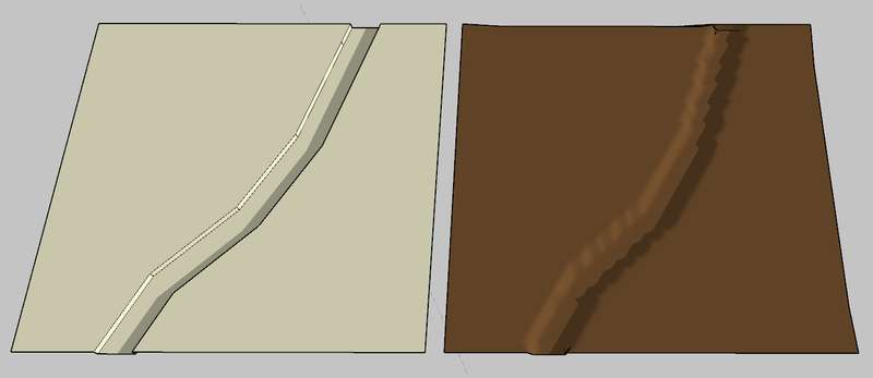
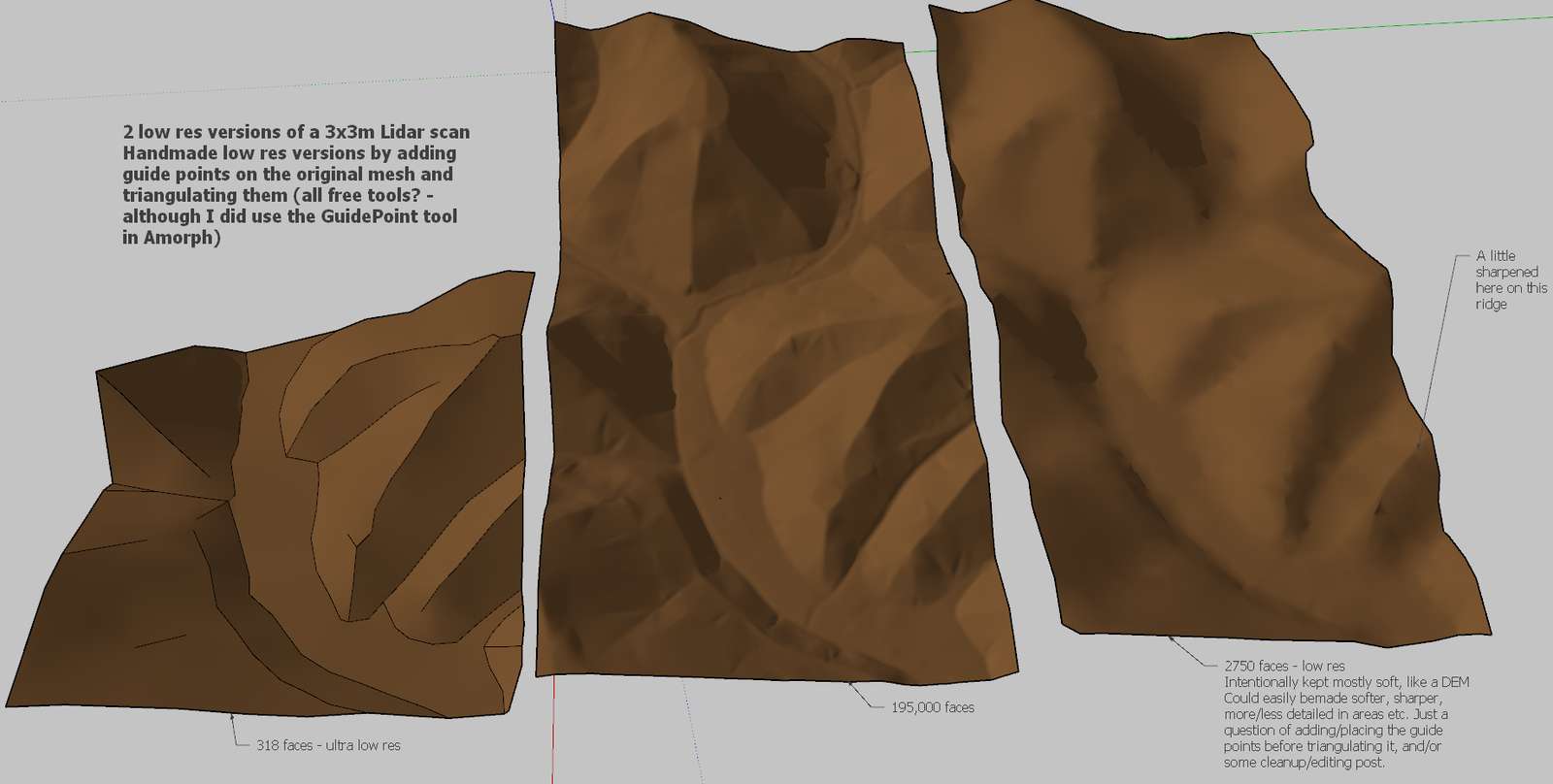
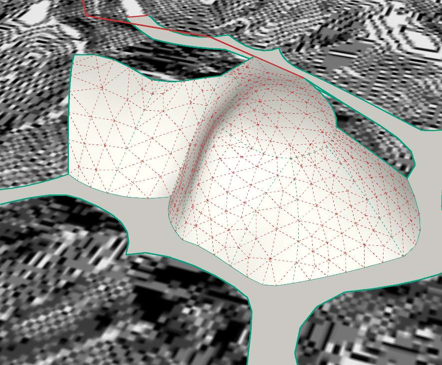
      Speaking of test results, using Meshlab and a variety of other tools, as mentioned earlier I was able to take a terrain mesh containing over 400,000 faces and reduce it down to a mere 10,000 faces while still being able to maintain an appearance that was very close to what I am seeking. All without the need to purchase anything. Plugins are great but they can't "fix" everything.
      But then you already have the solution then? Your 25 sq miles should be around 5-6 million triangles at 3x3m resolution, which should convert to around 150k faces in SU, which might work. Then you just have to figure out how to texture it with a 70+ Mpx orthophoto to get 1x1m resolution (which isn't much btw)...

      @unknownuser said:

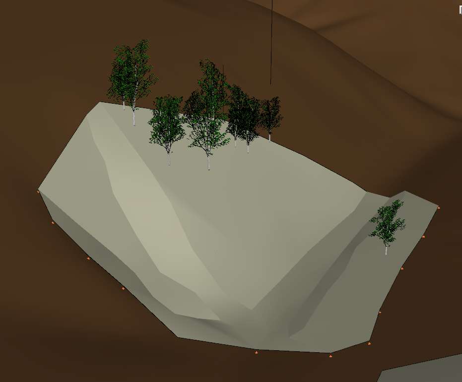
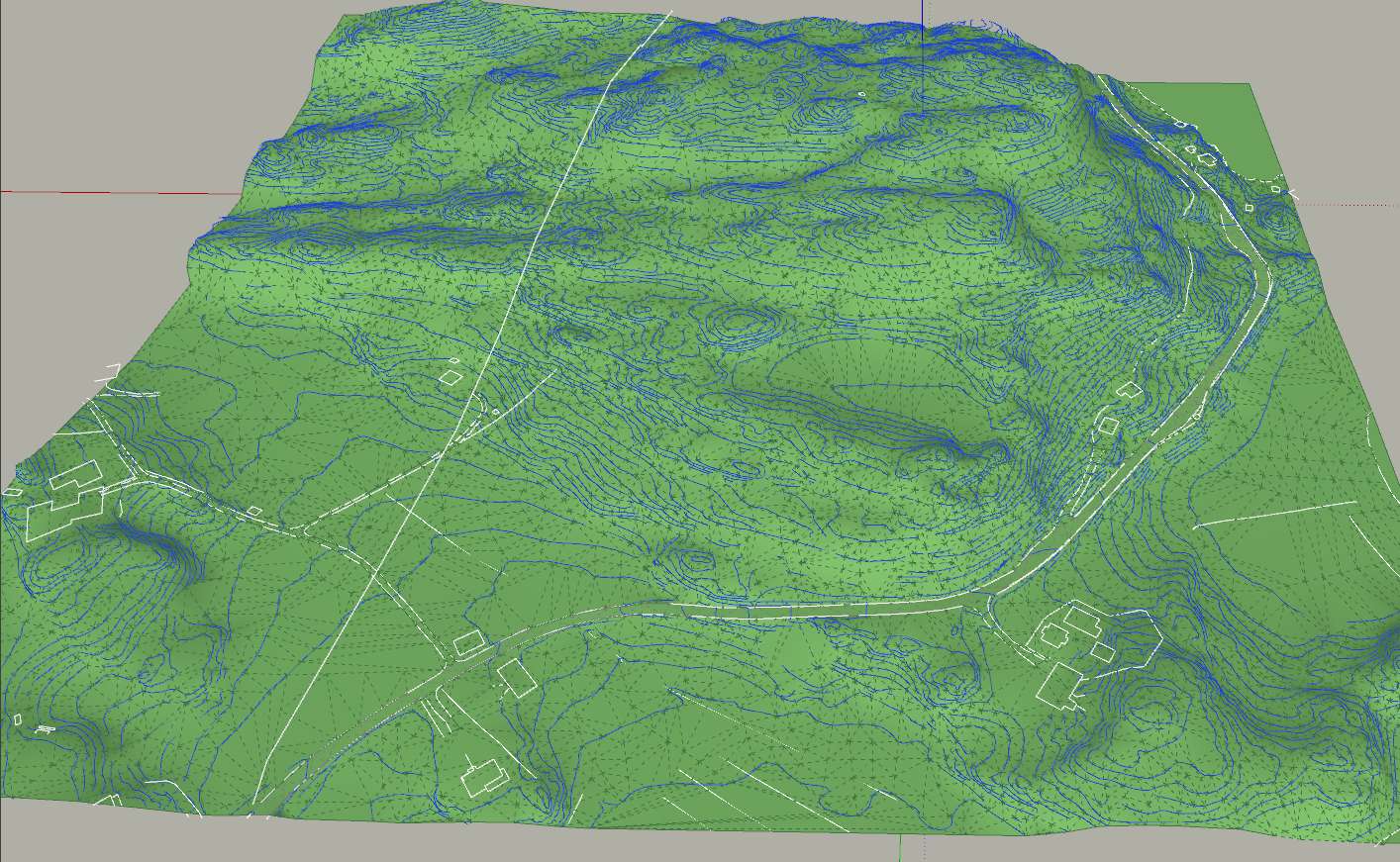
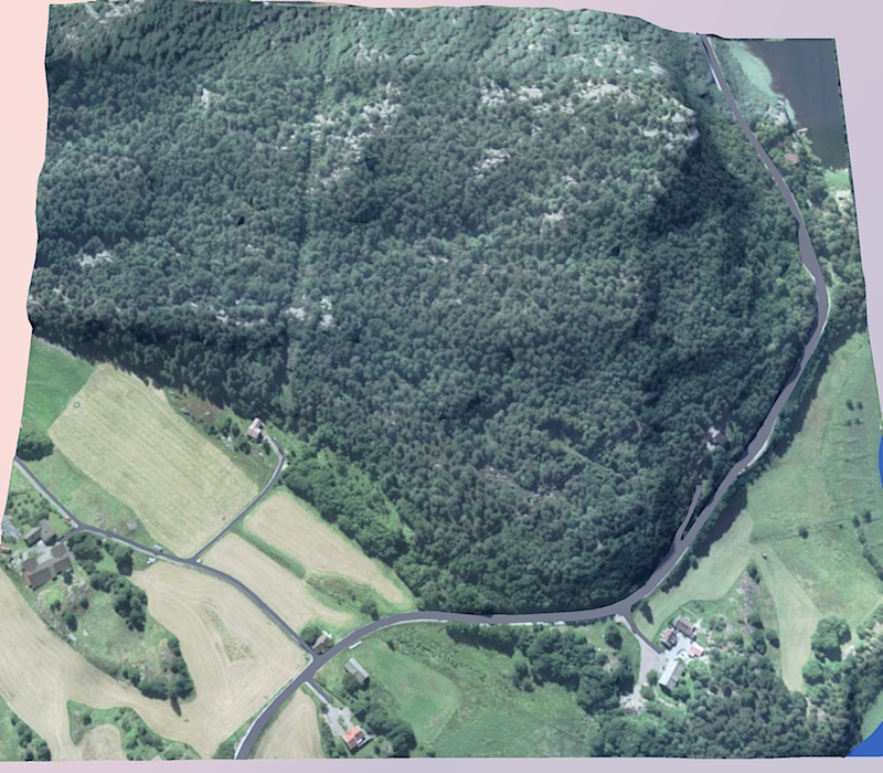
      We aren't talking about a small flat patch of land around a house or even a small sub-division here. I am planning to model an area of over 25 square miles in mountainous terrain and knew very well that it would not be easy before I even began the project. Sure, I could have simply used CAD or one of the other miriad of paid-products made specifically for a project such as mine, but what fun would that have been?

      Sometimes it isn't about the destination but about the journey itself.

      OK. As you don't seem to be interested in advice along that road (if it costs anything at all) I think I'll stop spending my time on this "journey" of yours.
      Looking forward to see the results though.

      posted in SketchUp Discussions
      B
      bjornkn
    • RE: Large Terrain Mesh

      I have no idea what makes you think that I will get any bucks by advicing you to buy a plugin?
      I make no plugins or programs currently, and I will not receive any royalties or any other "bucks" by pointing at any non-free plugins.

      I don't use Meshlab (free?) or Global Mapper ($350+?), but have bought Amorph and Artisan, and am very happy that I did because it saves me tons of time and makes it possible to do things in SU that would be impossible without them. BTW I have also bought that Mootools/Polygon Cruncher as well as Okinos NuGraf/Polytrans (which will also poly-reduce) and many other tools.
      When I need to screw a screw into a wall I prefer to buy a (cheap) screwdriver instead of trying to use a hammer, or to spend hours/days looking for a free screwdriver or make one myself.
      BTW, I just did a little test on that handmade terrain I posted earlier. By downsampling selected areas with Amorph (10secs) it looks identical at a distance, and is now 4000 faces, and with the ortho photo intact. Even at <2000 faces it looks pretty good. As you're not interested in solutions that costs a few bucks I won't bother to post the results though.

      But, by all means, it would be great if you could write a free polygon reducer plugin that makes it possible to do local/area(/altitude?) reductions, and will allow you to stitch the parts together easily afterwards. I'm sure you could even charge a few bucks for such a plugin - and I would probably buy it too πŸ˜‰

      posted in SketchUp Discussions
      B
      bjornkn
    • RE: Large Terrain Mesh

      @dbwv69 said:

      I am starting to believe that Sketchup simply doesn't have the horsepower to do what I need to do.

      It's not so much lack of horsepower as getting used to driving with a manual shift πŸ˜‰ But if you want to drive at top gear everywhere you'll not gonna make it work for you.
      If you absolutely need to have a 3x3m res in all of your terrain then SU is not the program for the job. 5-6 million polys can probably easily be handled with Blender, and so can most other non-free 3D programs, like LightWave, which is what I'm using when I need thousands of instanced 3D trees, rocks, grass and lots of polys.
      In SU you have to "adapt to the terrain" and keep your polycount as low as possible wherever there's no need for lots of detail.
      The SU community is so spoilt by all the great free plugins available, as well as lots of affordable ones. Sometimes you can't do without them, but sometimes you can spend a few days/weeks working hard instead of spending $39/$149.

      @unknownuser said:

      Does anyone know of any decent (free) 3D Mesh poly reduction programs? I heard that Blender can do it but I'll be darned if I can make heads or tales of it's odd user interface. I also tried Meshlab but it crashes at the drop of a hat.

      Then there is the problem of converting DXF or other files to formats that the various 3D programs can import. You'd think the 3D software world was ran by monkeys with all the variations of files and interfaces that are out there.

      This is starting to give me a headache the size of Texas.

      As advertised on this page currently there is http://www.mootools.com/plugins/us/sketchucation/index.htm which also comes with a poly reducer, the Polygon Cruncher. It works great, with lots of control, but again it is not free.

      posted in SketchUp Discussions
      B
      bjornkn
    • RE: Large Detailed Topo File

      Split your terrain into several smaller parts, so that when you need to drape something you don't have to do that with the entire model/terrain as receptor.
      Saves a lot of time!
      And it is easy to reassemble the parts if you need to.

      posted in SketchUp Discussions
      B
      bjornkn
    • RE: Large Terrain Mesh

      DEM and TIN are not SketchUp specific terms, but pretty general.
      A DEM is a grid with evenly spaced x and y coordinates. For each intersection there is an altitude value. Which means than when viewed from above with no perspective any terrain will look exactly the same, just like a flat grid. It would be impossible to see if it was from the Alps or Holland. No roads, rivers or anything will be visible.
      It uses the same grid everywhere, and wastes a lot of unnecessary vertices on flat or even large areas. Even flat water may use thousands of vertices.
      A TIN, which means 'Triangulated Irregular Network' is different, because it only should place vertices where there needs to be one, like along a road for instance. Typically they are often made from contour lines stitched together.
      The advantage is that you can see from above what the landscape looks like, where the roads are etc.
      You can also get sharply defined roads etc, unlike with DEMs where everything is soft. A road in a DEM with a resolution of 6x6m will be pretty much invisible even when seen in perspective.
      The main advantage of a TIN, particularly in SU, is that it can be made to cover a huge area at very little cost face-wise, because you can make it as coarse you like in distantly viewed areas, or as detailed as you like in ROIs that will be seen closeup.
      Polygon reducers, like those present in Amorph and Artisan will be able to remove a lot of unnecessary faces in DEMs in areas of low frequency, like flat areas etc, but you will still not get crisp edges along roads etc. With orthophotos applied you will often get water climbing up on the terrain around lakes, rivers etc (just take a close look at lakes in Google Earth!) because the resolution is too coarse, and the waterline doesn't follow the square grid. With a TIN you will get a completely flat water plane which could be perfectly textured.
      You can get good results with SU and the "From contours" tool in Sandbox, but be prepared to do lots of cleanup.
      It isn't that bad actually. The technique I've used for years has been to draw coarse contour lines on top of the imported ones, adding points wherever there's a change of direction etc, and often skipping several altitudes. And then skin a selection of such contour lines with Sandbox, cleanup by flipping edges to remove flat areas, and then explode to merge with the rest of the topo.
      The attached terrain was completely handmade using this technique. It took maybe 4 hours and is about 12000 faces?
      I tried a small part of that terrain using the original contour lines, but simplified, and it ended up with 40000+ faces and wasn't looking any better. Today I would've used Amorph.
      Attached also a version with orthophoto applied. As you can see the entire hill is covered with trees, so even that coarse topo was really overkill anyway. But today there very few trees left there - it's covered with houses, school etc. Unfortunately that job was canceled before I even got to start to build that school 😞
      Clipboard-3.jpgOrthoTopo.jpg

      posted in SketchUp Discussions
      B
      bjornkn
    • RE: Large Terrain Mesh

      Also using crude math, that would give you a resolution of 18mx18m each square.
      Or 14x14m with 400% and 12008. That is much more than you need in remote, less visible areas, but way too little precision for close-up areas as far as I can tell..
      I don't know if this is a paid job or not, but if it is I think you're wasting a lot of time trying to save a few bucks. I can't see how you could possibly make such a large area at an acceptable resolution from a triangulated point cloud. You obviously have access to the full data and CAD software since you can export contour lines and/or point clouds?
      With a TIN you can also easily align a topo orthophoto, because it is actually possible to see the terrain from above. It would also be very easy to make the terrain rectangular. And with Amorph you could output point clouds for the detail areas only and generate accurate meshes that passes through every one of those points. Great for building sites etc too.
      How are you going to handle vegetation, buildings, poles, masts, people, cars(?), tracks + the train itself?
      SU is not gonna like 300-500k faces + all the props and objects I'm afraid.
      Are you going to render this inside SU, or in some external program?

      @thomthom: I'm in Kristiansand (just updated my profile too )
      Just as unflat here as in Trondheim πŸ˜‰

      posted in SketchUp Discussions
      B
      bjornkn
    • RE: Large Terrain Mesh

      Yes, simplifying contour curves is a must, at least with the ones we get here in Norway from SOSI!
      You have a lot of useful tools ThomThom πŸ˜„

      posted in SketchUp Discussions
      B
      bjornkn
    • RE: Large Terrain Mesh

      First of all you need to decide what level of detail you need, and where you want it.
      If you're going down at ground level you need more detail, but you'll probably not getting that close to the entire terrain?
      There are typically two terrain methods, either using a huge mesh with evenly sized/spaced squares/triangles (DEM) or a terrain built from contour lines, with irregularly sized and spaced triangles (TIN).
      Using DEM you need a huge mesh to get any details, while with TIN you can add the details where you need it and make remote areas with just a few tris. If you have a flat area like a football field with DEM it may take many thousands of triangles, while with TIN you could get away with only 2. And at the same time the TIN version would be better defined because it would get precise edges as opposed to the DEM where everything gets kind of blobby. No sharp edges with DEM.
      In addition a TIN will show you the terrain in top view, while a DEM will only show a big grid.
      You can probably tell tha I'm not a big fan of DEMs πŸ˜‰ ?
      If you can get hold of a file with terrain in 3D contour lines (which is what I often get in) you have a good starting point. The you could simplify the contours and use Sandbox From contours to make the terrain.
      If not you would have to build it by hand, using Amorph and Artisan or similar.
      Attached is a very quick Amorph test on a small part of your terrain. ~450 faces. The control curves are dark cyan, and they can be shaped and detailed just as much (or little) as you want, and the mesh between them will be rebuilt and smoothed. I'd make it finer in regions of interest, and coarser further away from the action. As you can see you get a well defined border between the hillsides and ground (river?)
      Amorph is a great tool for terrains, which I wish I had found earlier. I've spent countless hours building terrains with the connect-the-dots technique, sandbox and FlipEdge...


      Clipboard-2.jpg

      posted in SketchUp Discussions
      B
      bjornkn
    • RE: Holes or Strange Patches in Terrain

      Curviloft and Tools on Surface should get you a long way with placing/making roads in landscapes.
      As I'm becoming an Amorph addict I would add that tool as well - great for making road curves and filling them with Bezier meshes as well as between road and cutout hole edges made with Tools on Surface.
      Artisan would be great too (another tool easy to get addicted to πŸ˜‰
      I'm generally a bit sceptic to "Instant" tools for making roads, windows, roofs etc - I always feel that I don't have enough control. But then I've never tried that Instant_Road... Maybe it's very good?

      posted in SketchUp Discussions
      B
      bjornkn
    • RE: Football Panels

      This is how they may look with Twilight.
      The red ones were made with SU native tools, and the yellow ones with Joiny Push Pull.
      Both were upsampled afterwards with Amorph, but could have been made higher res in the first place.
      The upsampling also made the seams more visible because their edges were smoothed too.rugby.jpg

      posted in Newbie Forum
      B
      bjornkn
    • RE: Football Panels

      A simple way to make a rugby ball would be to lathe the profile/curve a quarter circle.
      Then extrude each end/inside face a few mms.
      Then scale that face towards the center, once top/bottom and once outside towards center - about .98?
      Then you make it a component and rotate/copy 3 copies.
      A little tweaking and smoothing and you're done πŸ˜„

      Another way would be to use Joint Push Pull tool.
      Curviloft, Artisan, Amorph are all plugins that could be used here.

      posted in Newbie Forum
      B
      bjornkn
    • RE: Plugin sub-layers

      Never seen such a plugin. Would be nice to have πŸ˜„
      What I often do is make numbered layers, like 0HouseA, 01HouseA_interior, 02Furniture etc. I keep top level layers at 0, next level at 1 and so on. It doesn't fold, but it sorts nicely in the layer list so that all the top layers ends up at the top. With imported DWGs with lots of layers it helps a lot to get your own layers at the top πŸ˜‰

      posted in Newbie Forum
      B
      bjornkn
    • RE: Automated house model from height coordinates

      Yes, there are public folders too. I see that my post could look like that I thought/wrote that there were no public folders?
      I have not tried the public variant, but the privately shared ones works very well.

      posted in Newbie Forum
      B
      bjornkn
    • RE: Automated house model from height coordinates

      Have you tried Plan tools from ThomThom?
      http://forums.sketchucation.com/viewtopic.php?t=30512
      Looks like they could do the job?

      BTW, Dropbox lets you share folders by invitation only. They are not publicly shared. Works great IMO.

      posted in Newbie Forum
      B
      bjornkn
    • RE: Website help.

      And when you have your domain/host problems sorted out you should consider carefully what you should use for creating your web pages. CMS systems are mostly useful for sites where you add a lot of new stuff all the time, but they are not that easy to set up or maintain. I've made 2 Joomla sites for clients, but it turned out to be a complete overkill, as they can't manage to add aricles and/or images. They managed to mess things up though.
      If you don't know much/any about html, css, php, Javascript etc, and don't have someone to set his up and run it for you, I think you should look at a more direct approach.
      My absolute favourite is Xara Designer Pro from http://xara.com
      They also have Web Designer available. I've been using Xara, which is basically a very fast, powerful and versatile vector drawing program, for many years for all kinds of graphics and print stuff, but hadn't used its web site tools before a couple of months ago. Now I don't use anything else at all πŸ˜„
      It is extremely easy to use, and everything shows up on the web exactly as you designed it. It comes with a lot of templates too, to help you get started, as well as drag&drop widgets for eCommerce and lots of other stuff. Want to show a video - just drag it from Explorer and drop it into your page.YouTube, GoogleMaps, PayPal etc. And if you want to you could also add Javascripting, php etc...
      It also publishes your site for you via a built-in ftp-client.
      And there are two very helpful support forums for it, at http://www.talkgraphics.com/ and at http://board.xara-users.info/

      FTR I'm not in any way attached to Xara, but just a very happy longtime customer πŸ˜„
      Xara is a gem πŸ˜„

      posted in Corner Bar
      B
      bjornkn
    • RE: Modeling buildings from multiple matched photos

      Yes, it undistorts the images. There is an external program where you match ponts in the various photos. Then it calculates 3D space vertices for those points and distortions for the lens(es)before it exports it all to a set of photomatched scenes in SketchUp format.

      posted in SketchUp Discussions
      B
      bjornkn
    • 1 / 1