Modelling an Island using SubD & Vertex Tools?
-
Hi, Could anyone offer some advice in regards to modelling an island using SubD/Vertex Tools which is 1.4Kms long. I've recently taken on a project & will be providing some Concepts of building designs to be constructed on an remote island. Never having modelled on this scale before I'm trying to establish a Work Flow approach of some sort using SubD & Vertex Tools. Each end of the Island has been surveyed in detail (the building sites) but the remaining 80% is only Google Earth style basic contours. I have access to some good quality photographs as reference but mainly I will need to interpret visual detail. I've already created a detailed outline of the island using Google Earth in SKP. The Island is mostly quite rugged terrain overall. I'm fairly new to SubD/Vertex Tools & see the advantage of using the Quad mesh. Do you think SubD/Vertex Tools would work for this approach? I was going to break the Island up into large blocks (sections) to work on at first with maybe a grid format of 5000mm? to get started & then infill areas as required. Any suggestions would be greatly appreciated. Thanks Steve
-
It's a little bit hard to tell without any visual references.
But I'm wondering if SUbD for such a large terrain would make the model very heavy. Maybe Sandbox Tools and Vertex Tools is enough? It really depend on the scale of your illustrations - if you do birds eye views then you don't need much detail for the terrain. Nor do you need much detail for the background terrain. -
As Thom says, without some image to describe the scenario, it's hard to advise.
-
Maybe Curviloft could be an option as well. Easy to transform contour lines to terrain, quads for uv mapping, easy to control complexity. It all depends on the typology of the terrain.
-
Yea, there is also TopoShaper which might help: http://sketchucation.com/forums/viewtopic.php?f=323%26amp;t=52039
-
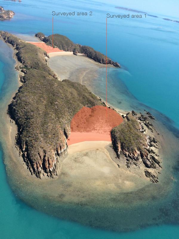
I hope this photo reference for my query is helpful, the scale here is deceiving as this island has daily 7 metre high tides. The red shading indicates the survey detailed areas.
-
How will you present it? Close ups at your sites? Large overviews, birds eye perspectives? This comes down to level of detail in relationship to the camera you will be using for your presentation.
-
Mostly I'll be only dealing with the two surveyed areas in my presentations for the Concepts & later Construction drawings as per documentation Sets. This project is for an open ocean fish farming company & they have requested an overall view of the whole project in context. The close views will be isolated to Building perspectives, maybe some early sections & groups of buildings which would only hint at immediate surrounding terrain. Then also some large overviews, birds eye style perspectives as well. Do I need to use two different approaches to achieve the one out come?
-
I think I would start:
- making a low-poly version of the whole island (low poly = keeping SketchUp alive and work speed fast)
- setting up all my camera positions
- refine a few areas to high-poly versions for close ups (if needed) in the individual camera positions
Start with massing everything and refine from there.
-
I second that.
-
Thanks for all the replies, maybe I was a bit naive with my initial approach & will now need to reconsider the process. Is there any recommended video tutorials that would help me get started with large area terrain modelling?
-
Do you live locally to the island? A drone survey would make short work of that easily.
-
Thanks yes I've just got onto that & have contacted a drone survey operator, it's quite amazing the amount of information that can be gathered from the drone.
-
You could model the island automatically with photogrammetry, using the pictures from the drone.
-
@skeerc said:
I've already created a detailed outline of the island using Google Earth in SKP. The Island is mostly quite rugged terrain overall. I'm fairly new to SubD/Vertex Tools & see the advantage of using the Quad mesh. Do you think SubD/Vertex Tools would work for this approach? I was going to break the Island up into large blocks (sections) to work on at first with maybe a grid format of 5000mm? to get started & then infill areas as required. Any suggestions would be greatly appreciated. Thanks Steve
Sorry if i answer late (too late i suppose) i missed this post at all.
This can actually work. i'm pretty sure because i did a similar project and achieved a good result with the very same process you've described..
you can convert the low poly google earth mesh to quads, then detach some plate in the areas were you need more detail and use a mix of sub-d and vertex tools to add geometry and deform it as required..
you will get an heavy, but still workable model, if you manage it properly..
Hello! It looks like you're interested in this conversation, but you don't have an account yet.
Getting fed up of having to scroll through the same posts each visit? When you register for an account, you'll always come back to exactly where you were before, and choose to be notified of new replies (either via email, or push notification). You'll also be able to save bookmarks and upvote posts to show your appreciation to other community members.
With your input, this post could be even better 💗
Register Login


Advertisement