Don't you mean .skb file extension - I've found it's NOT a good idea to delete .skb files.
also see http://sketchucation.com/forums/viewtopic.php?f=79%26amp;t=36969
Don't you mean .skb file extension - I've found it's NOT a good idea to delete .skb files.
also see http://sketchucation.com/forums/viewtopic.php?f=79%26amp;t=36969
Thank you Richard, another great idea to put in the toolbox, and you've invented the flatpack model too! I'm starting to travel my ideas around and this should be useful
Curviloft is your friend here http://sketchucation.com/forums/viewtopic.php?f=323%26amp;t=28586 which solved a complex extrude for me recently. also you only need to make one half. Sweep to rail looks useful [url][/url] and has some useful discussions. TIGs extrusion tools may help you too.
If you can draw it in both plan and side elevation, you can probably use the above tools to loft a surface - you'll prob just need to read around a bit
And for complex curves you can't go part bezier http://sketchucation.com/forums/viewtopic.php?p=100509#p100509.
@andyg said:
I dont know about length tho. Ideally, i would like to just draw lines on a layer, and then have SU sum up the lengths of all the lines on this specific layer. What would also be nice, if i could somehow highlight the all the lines on this layer, to visually check if i didnt forget any parts in the model. Anyone knows how to do this?
Regards,
Andy
If you look ½ way down this page http://sketchucation.com/forums/viewtopic.php?t=23991, TIG wrote me a script to add up hedge lengths from a separate line layer I was doing in the drawing - would that work for you?
Great plugin, very, very useful, and seconding the idea of building a/the calculator into the comment box.
Wonderful plugin, thanks, great to have instant primitives, plus helices!
Thanks sdmitch, another great tool, will speed up my decks and patios no end
What software do you have? some point cloud files benefit from some pre-processing before using them in CAD such as SU. Have you got Excel and something that both open and save/export dwg or dxf (Autocad, Bricscad etc)?
Also what is the data? will it become a terrain type surface, or is it buildings or sensor data? I ask because there are several ways to take a las file to say csv or dxf for SU import, some resulting in a more useful file than others.
Goto google cache of old Stackexchange page http://webcache.googleusercontent.com/search?q=cache;0j5MxQQhegsJ;stackoverflow.com/questions/13425551/convert-las-file-to-csv+%26amp;cd=1%26amp;hl=en%26amp;ct=clnk%26amp;gl=nz%26amp;client=firefox-a, a useful las to csv discussion there, with some solutions.
If you're just going to grab the image and don't want the data, why not use your local/region council's GIS it's (usually) much more upto date than google's. Shadows are usually less of an issue too.
Thanks Jeff - I may not need the extreme bend (If I do I'll draw contours between the sections and skin them with from contours)
and thanks too for showing a bit more about using Curviloft - I was really amazed when it lofted the individual stretches of stream (and gave the option to tweak the result).
What an amazing plugin this is, Thanks very much Fredo
Anyway I'm drawing a model of part of a river for a planting design - there's no money for a surveyor so I drew cross sections and used Curviloft to loft between them using the streamline as the curve. All worked perfectly, BUT one section is a bit odd (a result of
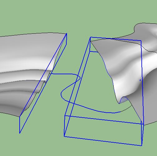
straightening the channel) and I can't find a way of skinning between the profiles - is there a way in Curviloft, or would another tool do the trick? Due to the extrme bend of the stream it's hard to see a way of using new profiles between the existing one as a way to bridge the problem.
When I opened that article my eyes automatically flicked to the date area - 'cause this would (normally) be prime April 1st territory.
Definitely extremely useful - you've got my vote
You might have to do it in a two stage process, importing the line work first with SU, and then using ImportDXFtext plugin from TIG http://sketchucation.com/forums/viewtopic.php?t=23002 - make sure the read the plugin's page. I do not know if the plugin will set your text at height though.
Are you able to open the dwg yourself so you can clean it? Also what Autocad version is the dwg in? Things are often easier if the file can be saved to an earlier acad version, sometimes even 2000.
Thanks Amoura, I was looking for a way to do that just this morning for a pathway.
When using the stamp tool I always find problems setting the level of the final surface position - is there some (unknown to me) way of controlling position using a key combination? The little up/down pair of arrows that come up always look so enticing but no amount of keying does anything...
SD Mitch has a plugin that'll draw polygons by apothem - http://sdmitch.blogspot.co.nz/
Thanks very much paul, can never have enough doors