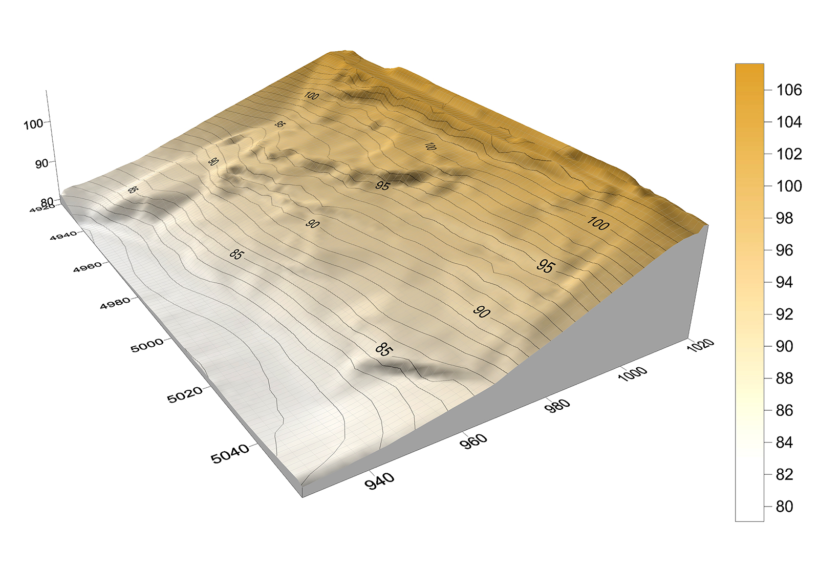
 That looks good Fredo from the gif, I'm still on SU V14 so can't see your posted model but the surface looks similar to my terrain model, which from memory looked like the actual terrain. The contours can differ slightly when generated solely from points (as in my attached terrain model) as this method does not take breaklines (distinct interruption in the slope of a surface, such as a ridge, road, or stream)into account. But that depends very much on the particular site.
Posts
-
RE: [Proto] Generating Terrain from a Cloud of Points
-
RE: [Proto] Generating Terrain from a Cloud of Points
Here's some data to try out...a survey CAD drawing, both 3D and 2D, together with raw data (600 points, an interpolated 5m grid of the data and a visual of the terrain model as generated by the data.
-
RE: Importing a CAD drawing
A DWF file is a bit like an 'AutoCAD PDF' file, a format that allows others to view, review, or print design information – without these people needing to know AutoCAD or other design software, so no good in SU. I can only suggest saving the drawing as an earlier dxf or dwg format such as 2006 or Release 14 from within AutoCAD.
-
RE: Converting photos to black and white
The following link is good for Gimp/Photoshop and is quick and easy to follow....
http://www.youtube.com/watch?v=yupmgRJqwTc -
RE: How to Print/Export Individual PDF's?
Kris, Dave R is correct when he said Adobe Acrobatmight be worth a look as it also lets you add Watermarks to pdf files which can be useful for client previews- or add a password to restrict users from opening, printing, and editing PDFs. You can also embed video files with the Pro version- so you can embed an SU animation within the pdf file created with Layout to further enhance your presentation.
-
RE: How to Print/Export Individual PDF's?
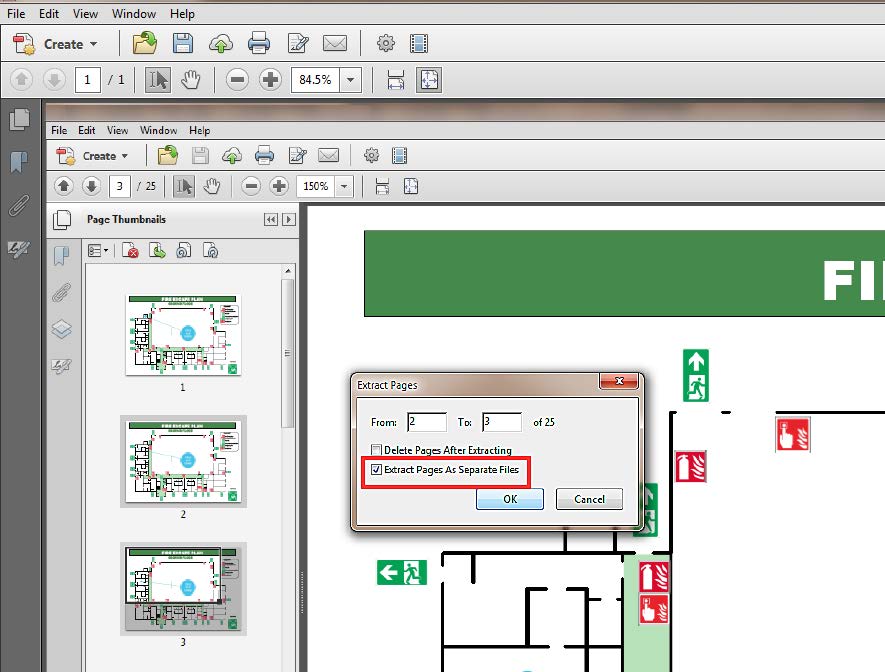
Adobe Acrobat does have this facility but not the free version (Adobe Reader) as far as I know. There is an a free online service called http://www.splitpdf.net. You simply upload the file and tell it which page you want extracted. It then returns a pdf containing only the page you selected. Unfortunately, you have to repeat this step for each page you need to extract but it's an easy process.
-
RE: Squiggly line on dimension Text-Layout
Thanks Dave R & jiminy-billy-bob
-
Squiggly line on dimension Text-Layout
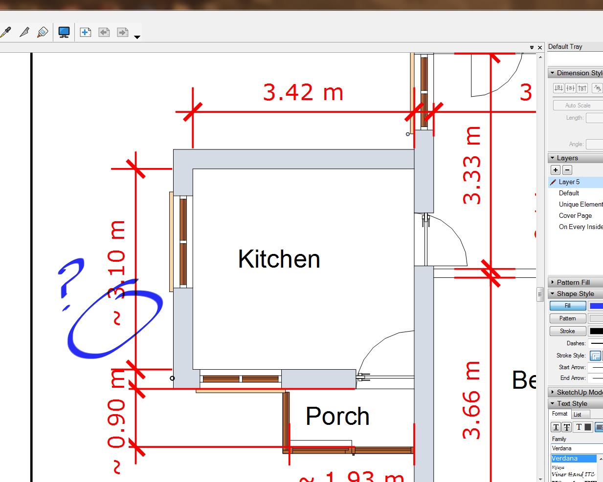
I've moved a 'viewport' in Layout and some of the Dim Text are now prefixed by a squiggle. It happens whether or not I preselect the Dim Text as well as the viewport or not. If I delete the dimension re-dimension all is OK, but how do can I avoid this and can anyone tell me what it means?
-
RE: Dynamic vector Brick pattern
I'm not sure if this will do what you need but there's a 15 day free trial...http://extensions.sketchup.com/en/content/oob-layouts
Otherwise why not make the pattern from within a CAD program. I'd imagine most packages have a pattern function. -
RE: Plugin to make tiles
Have a look at the Oob plugin at http://oob-su.com/. It's got a 15 day free trial.
-
RE: Door Components for thick walls
Have a look at the tutorial by Gaieus...
http://sketchucation.com/resources/tutorials/36-intermediate/321-window-cut-hole-thick-wall -
RE: Useful win apps
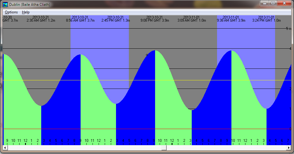
http://www.wxtide32.com/
Wxtide32 shows graphically tide times at various locations around the world from 1970-2037. However it no longer includes Ireland or the UK as the harmonics used to calculate these tides are under copyright to the United Kingdom Hydrographic Office (UKHO), under control of the UK Admiralty, who will not release them for non-profit making uses. I have kept an old version (V2.6)which has all the data. PM to get links to these.(Windows)
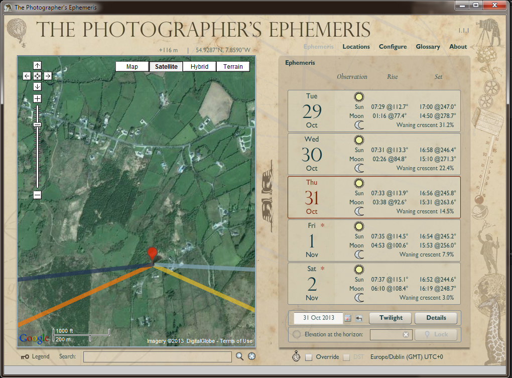
The Photographer's Ephemeris (Windows and Mac) is free at http://photoephemeris.com/. Its a great program to to help landscape and nature photographers plan their shoots (as in, where and when will I find my next glorious sunrise?). Visualize sunrise/sunset/moonrise/moonset with overlay to Google Maps. Gives time of sunrise, sunset,Azimuth of sunrise, sunset. Great for planning time lapse for sunrise as you can predict exactly where the sun will rise with respect to ground features from the map. Also available for iPhone although I haven't tried this.
-
RE: Scrapbook line weights
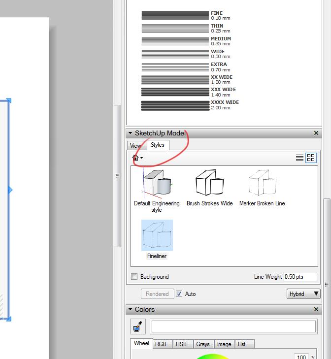
Forgot to add a screen pic of the last post...
-
RE: Scrapbook line weights
In Layout, go to the Sketchup Model panel and pick the Styles tab, here you can change the style of the active viewport to any of the saved styles. I haven't tried it but it should work. You can create a style in SketchUp to suit your needs (Line Thickness, Colour etc) or download a style.
-
RE: Raster to Vector or Sketchup importing SVG
Scan2Cad, http://www.scan2cad.com/ has been around for a long time, but its current release Release 8.3 is not cheap. It might suit some peoples needs though, & there is a free trial. It recognises and can edit text in images and supports batch processing. Its probably one of the best available bits of software for complex raster conversions out there. It's a few years (10 maybe) since I used it but I remember it as a highly competent program. As far as I remember AutoCAD Map had raster to vector functions built in, so our office switched to that on cost grounds.
-
RE: Scrapbook line weights
Select the Pencil tool from the main toolbar and sample one of the Line Weights directly from the Scrabbook, no need to drag it into your workspace, the line weight sampled is then applied to the pencil. Any line, rectangle, arc etc. will then have this thickness.
-
RE: How Not To Build A Shed.
Pure Gold!! I feel a SU challenge coming on! Is there a plugin to....? Nah, maybe not!
