[Plugin][$] TopoShaper - v2.7a - 01 Apr 24


-
@fredo6 said:
@sketchartist023 said:
The resolution is also very acceptable considering the width of this model test is only 4 inches

I will read how to change resolution in case I need those smaller ones that you mentioned too. Hopefully, for 3d printing purposes, it will be useful to keep Thank you much for your help!
I think your model would benefit from a higher resolution, as the terrain is basically flat with some very local deeps.
Also, you can always generate the terrain with its new isocontours (which would be clean), and then
- extract the group with these isocontours
- use them to regenerate a new terrain, possibly with another resolution.
Fredo
That is great info thank you
Whqat would I likely have to do to generate new isocontours? Do you refer to within the same plugin? I can see howthat would benefit for both generation and time of generation without errors so I'd like to try that method for sure because my SU crashed with this last test. Likely a maxed memory usage idk but new isos would be ideal I agree with this resolution need. Thank you very much again for everything EDIT: The new iso's might also rid the use of artificial contours I would imagine too, to that would be less work for my end if it works out well with generation
In other words, I wouldnt have to manually erase them one by one after alignments -
@sketchartist023 said:
What would I likely have to do to generate new isocontours? Do you refer to within the same plugin?
When you generate the geometry, you have the option to generate the iso-contours for the terrain. These iso-contours are those corresponding to the generated terrain and thus may differ from the original ones. They are created as a subgroup of the terrain group.
-
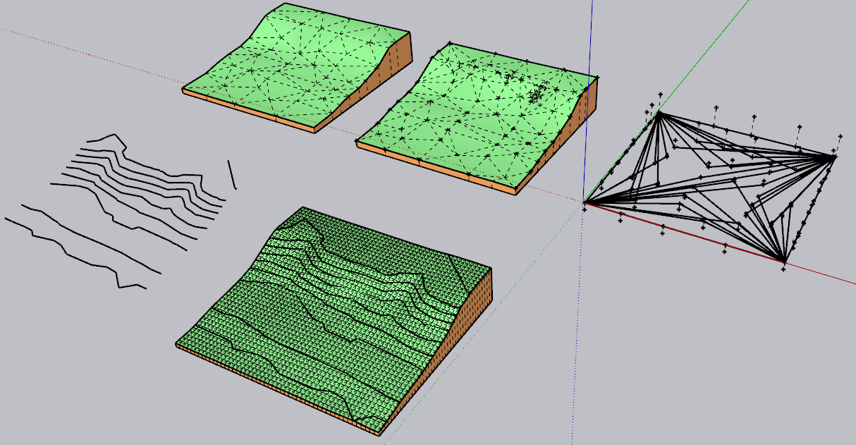
I have very accurate site contours for a large, hilly site. The contours were drawn by a civil engineer and show the proposed conditions, including many vertical retaining walls. I have used TopoShaper to generate terrain from the contours, but it (like the default SketchUp version) doesn't seem to be able to handle vertical faces. See views below of contours and Toposhaper results:


Clearly a lot of detail is being lost here. Does anyone have any suggestions for how to handle this accurately?
@Fredo6: Thanks for your work creating this.
-
This is a limitation of Toposhaper. Vertical faces should be created after the 'natural' terrain has been generated. Vertical faces usually correspond to excavations, road borders, etc.. and should be created along with these objects.
-
Understood, thanks.
I'm curious whether there is another program out there that can create accurate models with vertically stacked contours.
-
@unknownuser said:
I'm curious whether there is another program out there that can create accurate models with vertically stacked contours.
MeshLab http://www.meshlab.net/
-
Hello,
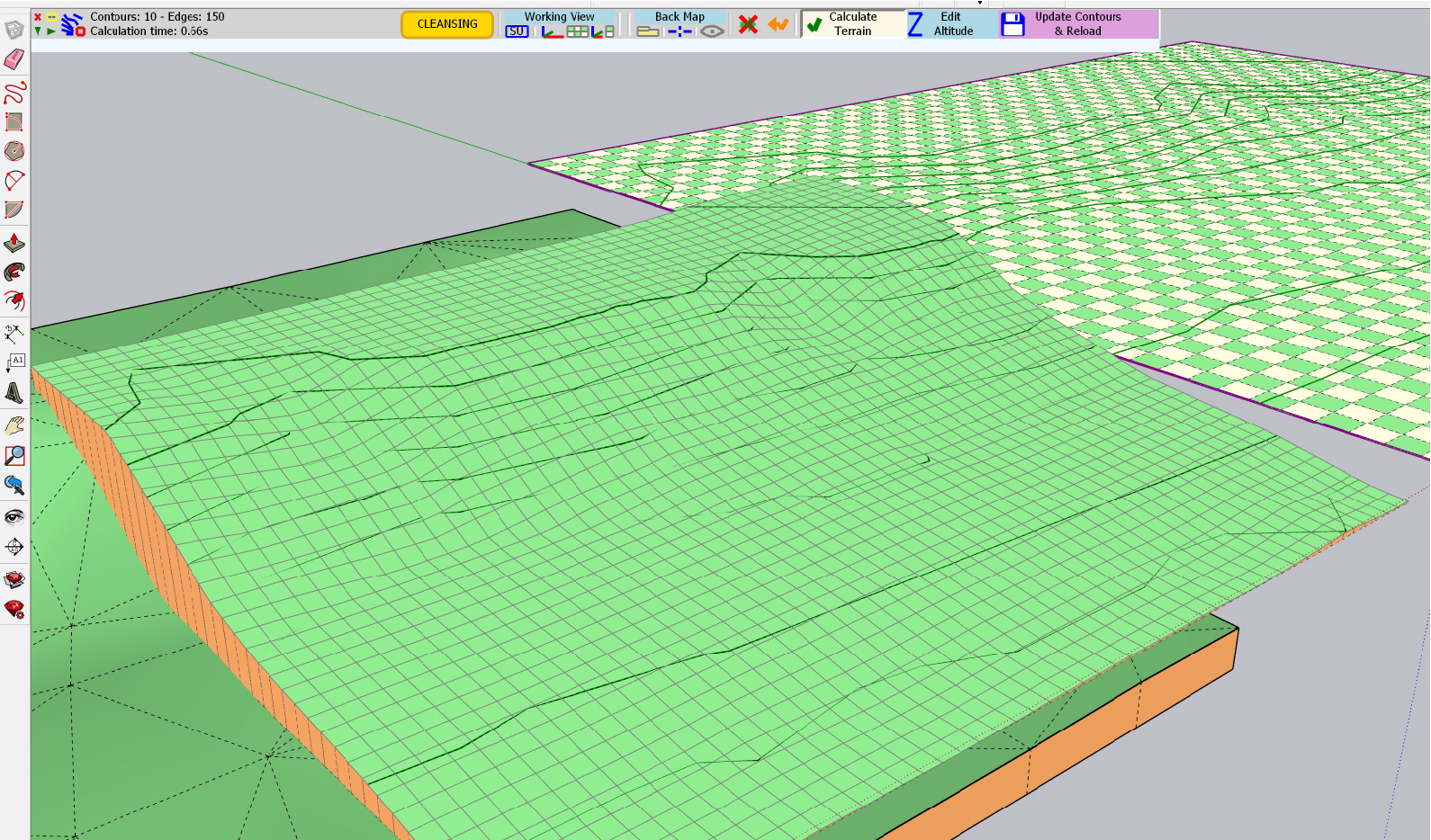
First off, your plugin is remarkable! The terrain from point cloud is working fantastic, but I am running into an issue with a crash to desktop on generation of the quad terrain from ISO-Contours. I tested the example files using the same method and it generates fine. I have attached my file, could anyone maybe explain what I am doing wrong?Thanks!
-
I don't have a problem
- when generating the triangulated terrain from guide points
- when generating the terrain in quadmesh, after extracting the iso-contours from the triangulated terrain
I wonder also what is the object mixing guide points and edges on the right (picture below).
Can you tell me where it crashes.
Fredo
-
The object is a triangulated point map DXF import.
It crashes to desktop approximately 1 second after generating the terrain from ISO contours, I have attached images. I am going to test generation on a different PC today and see if that works.
-
Hi thanks a lot for this plug in, I've been looking for something of the sort for a very long time.
I have a question, and aware this might not be the right place but maybe you're able to address me to the right topic.
I've got the elevation data in a cad file (from a survey), but how do I import it into sketchup so that it recognises it as guide points?
-
Fredo, your plugins give sketchup a huge lift and usefulness that without them sketchup would be second rate.
many thanks for all your plugins and thank you for offering them free... sketchup should be paying you.! im going to donate to you now,! -
Onto another project with the great TopoShaper! You know what I think would be nice (when you work on this again)--if Toposhaper made separate components of the contours and terrain models, and put them on new separate layers. These are things I do every time to be able to work with it thereafter. That's what I think anyway.

Thank you for the great plugins!
-
@pbacot said:
Onto another project with the great TopoShaper! You know what I think would be nice (when you work on this again)--if Toposhaper made separate components of the contours and terrain models, and put them on new separate layers. These are things I do every time to be able to work with it thereafter. That's what I think anyway.
Thank you for the great plugins!
Contours and terrain are already created in separate groups.
I can however put them of specific layers if it helps.
-
As they are both made as Groups you can easily select each of those in turn - in the Model or using the Outliner, and then use Entity Info to assign another preferred Layer [Tag] to them...
-
Thanks for the suggestion.It should be easy but I spent some time figuring out how to get the parts organized this time.
-
Hi, I was successful in generating a terrain with skirt from my 2D contour map, however, I'm trying to export to Sweet Home 3D in DAE, 3DS, or OBJ formats but the only format that is working at all is the DAE format. Even so, the terrain is coming in as 3D contour lines only and no surfaces or skirt. I'd like to place the home I designed on the terrain, but can't seem to figure out how to bring the 3D model into Sweet Home in a useful way. Am I missing something in Toposhaper, Sketchup, or is the DAE file format a limiting factor?
Any thoughts would be appreciated....MTHPumps -
Hi this is still a very valuable plugin and one of the most powerful ways of transforming CAD typographical information into 3d. It would be even more powerful if we could get it to output meshes that were compliant with the new Quad workflow that subdivision surfaces utilizes. I imagine you're familiar with the requirements. would it be a big job to update?
-
@mthpumps said:
Hi, I was successful in generating a terrain with skirt from my 2D contour map, however, I'm trying to export to Sweet Home 3D in DAE, 3DS, or OBJ formats but the only format that is working at all is the DAE format. Even so, the terrain is coming in as 3D contour lines only and no surfaces or skirt. I'd like to place the home I designed on the terrain, but can't seem to figure out how to bring the 3D model into Sweet Home in a useful way. Am I missing something in Toposhaper, Sketchup, or is the DAE file format a limiting factor?
Any thoughts would be appreciated....MTHPumpsThe problem might be in Sweet Home. The terrain generated by TopoShaper is just a regular group with a set of regular faces.
-
@teknoel said:
Hi this is still a very valuable plugin and one of the most powerful ways of transforming CAD typographical information into 3d. It would be even more powerful if we could get it to output meshes that were compliant with the new Quad workflow that subdivision surfaces utilizes. I imagine you're familiar with the requirements. would it be a big job to update?
Are you referring to the properties of the diagonal of quads?
-
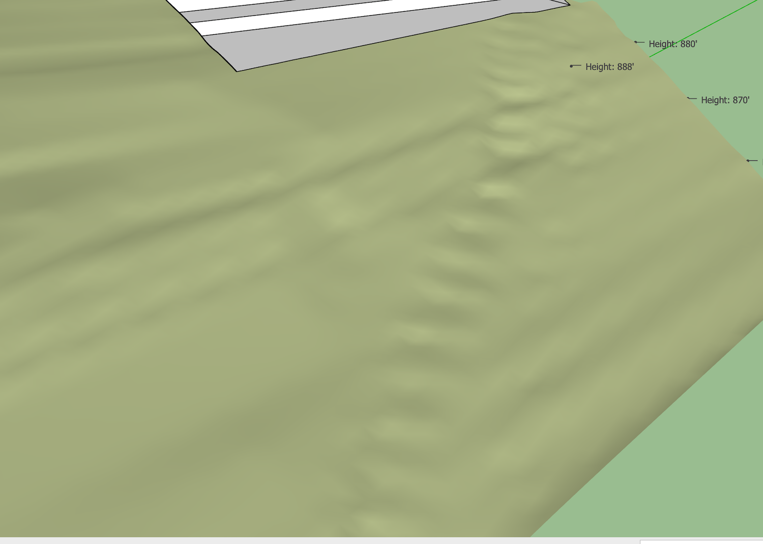
I wonder if there can be a solution to the effect of "stair-stepping"? In this image you see a couple of conditions. One is the long steps in line with the contours, for no apparent reason--the contours are fairly even. One low slope area becomes a little plateau followed by a "step" to the next contour.
There's a dirt road traversing the slope. While i don't expect much definition in this case, the steps or pockets along the road are misleading.
Is some interpolation required? The contours are at 2' intervals. Or is the resolution of the grid too high? I chose a grid that turns out to be about 2.5' (more fine that I generally use).


Advertisement