Bona Saturnalia!! 
Thanks hepf, it's very fun!! 
@l.vii.c said:
pichuneke
"What can I say... I always enjoy your models, and I spend some time "visiting" them"
Thank you
Good luck during the "tour" in my model
It is possible to "go inside" in all temples and pyramids, which are in the model.
I saw the sketchup version, but I am having problems downloading the complex, better one from gamefront 
@crislink said:
Hi all guys!!
It's a big work, and I was wondering if someone here can help me, maybe just with some basic models to use in the maps and some tips (like gathering a big terrain surface from google Earth, but detailed)
I can't help you with basic models (My few roman models are very complex, you know, hundreds of hours of work and I can't share them  ), but I have read a lot about "Los campos flegreos" (that's the spanish name if you want to know it, as you live in a region that was part of Spain centuries ago
 ). Please bring us your work and let us know here!
By the way I would feel uneasy living inside the crater of the most dangerous supervolcano of Europe...
@l.vii.c said:
Hi
I have made a new model of the Giza Plateau. See here http://sketchup.google.com/3dwarehouse/details?mid=a0f1c6fd82310f023686bf90918d7fc8
Once the topic for the Roman theme, I will not spread the screenshots here. Link of screenshots here http://www.gamefront.com/files/22749886/Giza_plateau_rar
What can I say... I always enjoy your models, and I spend some time "visiting" them 
It works!
142.416,120.528,-0.533
142.416,122.201,-0.013
143.444,120.528,-0.013
140.002,120.528,-1.721
140.002,122.941,-0.965

I'll make the map later 
@tig said:
Here's v1.2 http://sketchucation.com/forums/viewtopic.php?p=298614#p298614
A ',' can now be used as a decimal-point, as well as a '.'... AND keep the d.p. values set in Model Units...This fixes pichuneke's problem
Thanks a lot, I'll send you a private message with a image of the results of my experiments 
@dave r said:
Out of curiosity, to what is 'Precision' set when you are using metres as the units?
@unknownuser said:
The precision for 'meters' MUST be 0.000 ! to get up to 3dps reported...
As a curiosity, some of Mars Curiosity instruments were tested in the place I am trying to make the topographic map (and thanks for teaching me the meaning of the expression "Out of curiosity") 
I attach you a capture with the settings I've been using. In spanish, but you'll understand it. And yes, I've been using a precision of 0,000 , as you can see in the attached image.
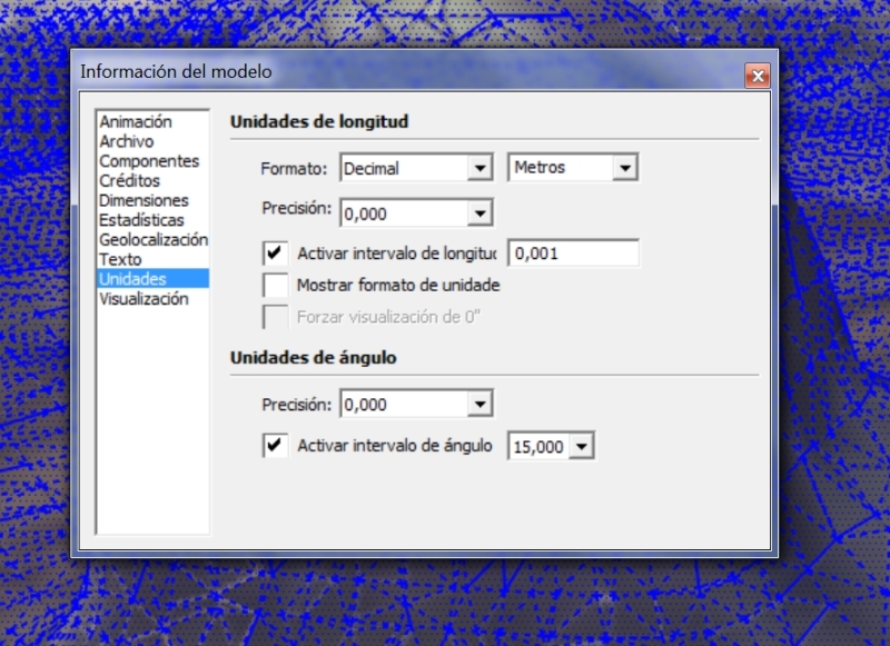
Tig, with the new code, the results are:
@unknownuser said:
Exportvertices2csv.new
#Exportvertices2csv:0x1a8911dc
Sketchup.active_model.selection[0].vertices.each{|v|puts v.position.x.to_s+','+v.position.y.to_s+','+v.position.z.to_s}
-141,225,-82,242,-19,325
-142,207,-82,242,-20,532
[#Sketchup::Vertex:0x1a4423d8, #Sketchup::Vertex:0x1a42d8e8]
I think you are right, Tig. Now I am trying to find way to change it in my preferences (although you know that the use of "," and "." varies a lot between countries). It's always been a problem, for example I use Libreoffice in Spanish and the use of the numeric punctuation in Libreoffice Calc is problematic, Mexicans use a system, here in Spain we use another...
Before doing what you told me (copy and paste your code), and after reading you, I selected mm instead of m.
These were the results for the first 5 lines:
142416.0 120527.0 -532.0
142416.0 122200.0 -13.0
143444.0 120527.0 -13.0
140002.0 120527.0 -1720.0
140002.0 122941.0 -965.0
After that, I selected again "m" (meters), and these were the results:
142.0 120.0 -0.0
142.0 122.0 -0.0
143.0 120.0 -0.0
140.0 120.0 -1.0
140.0 122.0 -0.0
A workaround would be to obtain the results in millimetres, and divide them by 1000, so I can obtain 142.416 and so on.
Now I am going to do what you told me.
With "meters" as the selected unit, I choose a face (a triangle):
@unknownuser said:
Sketchup.active_model.selection[0].vertices.each{|v|puts v.position.x.to_s.gsub(/^~ /,'').to_f.to_s+','p+v.position.y.to_s.gsub(/^~ /,'').to_f.to_s+','+v.position.z.to_s.gsub(/^~ /,'').to_f.to_s}Error: #<SyntaxError: (eval):155: compile error
(eval):155: syntax error, unexpected tIDENTIFIER, expecting '}'
....gsub(/^~ /,'').to_f.to_s+','p+v.position.y.to_s.gsub(/^~ /,...
^>
(eval):155
With "millimetres" as the selected unit:
@unknownuser said:
Sketchup.active_model.selection[0].vertices.each{|v|puts v.position.x.to_s.gsub(/^~ /,'').to_f.to_s+','p+v.position.y.to_s.gsub(/^~ /,'').to_f.to_s+','+v.position.z.to_s.gsub(/^~ /,'').to_f.to_s}Error: #<SyntaxError: (eval):155: compile error
(eval):155: syntax error, unexpected tIDENTIFIER, expecting '}'
....gsub(/^~ /,'').to_f.to_s+','p+v.position.y.to_s.gsub(/^~ /,...
^>
(eval):155
Hope it helps.
@tig said:
What format does your Topo software need.
The format:
137.0 122.0 -2.0
Looks to have the standard '.' as the decimal-point NOT ',' as you might use in Spain... and is separated by a space OR a TAB ? Using a ',' wouldn't work with that in the numbers too !
Also what units are expected etc?
The numbers after the decimal point truncate to .0 if there are no more ?
There are various ways of exporting things like this around the forums.
For example, do you really want to export 'vertices' ?
It's separated by a ","; and the '.' is the decimal separator. Anyway the software used to read it it's not a problem. I mean, I have copied the text numbers from a text editor. Anyway, if you want, you have here from notepad:
142.0,120.0,-0.0
142.0,122.0,-0.0
143.0,120.0,-0.0
140.0,120.0,-1.0
140.0,122.0,-0.0
So the text editor is not a problem. Sketchup generated that file as you read it.
I would like something like 142.24, 129.89, -0.025 (at least 2 decimals, or cm). It's for a topographical map I made by photogrametry. I am experimenting, to be honest, trying to find if this way of making maps is useful for my work.
I have to leave to go to lunch in 20 minutes, see you this evening. (The spanish lunch, a lot of food. But no siesta.) 
Tig, sorry to say that, but I have the same problem as the rest of some people here.
I am trying to export the points to import them with a software of topography, and I have this csv (sample):
142.0 120.0 -0.0
142.0 122.0 -0.0
143.0 120.0 -0.0
140.0 120.0 -1.0
140.0 122.0 -0.0
141.0 122.0 -0.0
138.0 120.0 -2.0
137.0 121.0 -2.0
137.0 122.0 -2.0
As you see, no decimals at all. I have chosen meters, "decimal" and precision 0,000 . No 0,000m extension.
I don't know what to do. I've read this thread and other similar to this: ExportCpointstoCSV (http://sketchucation.com/forums/viewtopic.php?f=323&t=40061). I don't like to ask for help and importunate you, but... can you help me?
@hepf said:
It's a non new. Today a long paper appeared on the most important italian newspaper, "La repubblica", under a beautiful title: "Julius Caesar was killed at the tram stop". The supposed spot of the murder lies indeed under the final stop of the tram line 8.
The real news is that Prof. Carandini has published with the editor Electa an important atlas of ancient Rome. The first such work from Lanciani's atlas, of over a century ago. It's important news, but with little public appeal. So Carandini, and Electa (which belongs to Berlusconi), both experienced PR's, are drumming up attention with these supposed breakthroughs. And they are right to do so, if it serves to attract public attention ... but do not fall too much for it ...
This is the illustration on the newspaper
Thanks a lot hepf, I will transmit your information to other people like me, interested in these things. We've been discussing about it in other forums.
@fluffy82 said:
@pichuneke said:
An offtopic, but I believe that everybody here will be interested:
Found the exact place where Julius Caesar was assassinated (in spanish)
Very interesting and very surprising. I always thought the remains of the Pompeian Curia were located under the via di Torre Argentina, behind the temples, and completely invisible.
Another trivia on Caesar, while we're at it: many people believe that the temple of Caesar on the Forum was the place he was cremated, but it wasn't. He was supposed to be cremated on the Mars field and, going there from the rostra where his corps was displayed during the speeches of Octavianus and Marcus Antonius, people started to yell he should be cremated on the Capitoline hill. In this quarrel, two people suddenly set fire to the carriage and people started throwing flamable things on it so he was cremated on the spot.
The most probable location would then be somewhere between the rostra and the cross section leading to the field of Mars on one hand and mounting on the Capitoline on the other. So: about between the Porticus Dei Consenti and the temple of Saturnus, or just behind it.
That's my opinion, anyway
In fact I thought the same as you... but then I made a mistake and I pointed the wrong place. You are right. It seems that the monument is not the one I said. In this photo you can see the exact place (it was known before, but not with precision). The problem is that I have no more information, at least for the moment. If you don't mind, although this is an off-topic, If more information appears I will link it here. Anyway I think that the place must be visible.

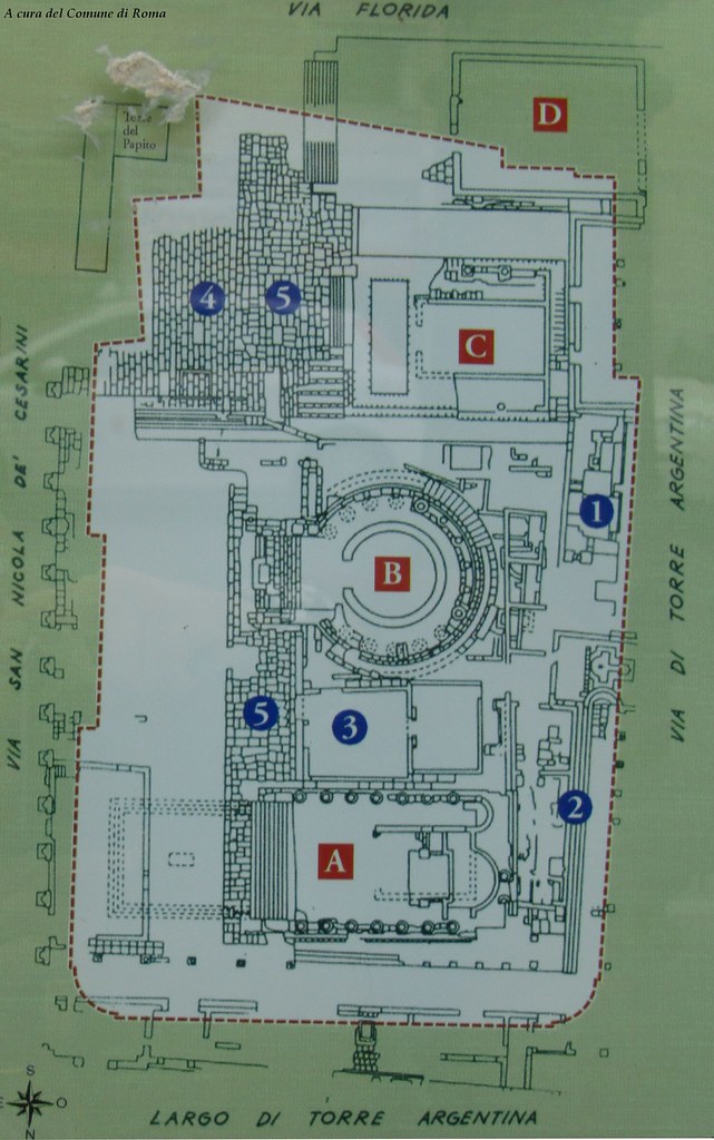
2011 Area Sacra, Largo Argentina por Roma ieri, Roma oggi di Alvaro de Alvariis, en Flickr
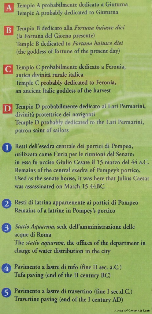
2011 Area Sacra, Largo Argentina por Roma ieri, Roma oggi di Alvaro de Alvariis, en Flickr
An offtopic, but I believe that everybody here will be interested:
Found the exact place where Julius Caesar was assassinated (in spanish):
Google Translation:
At the bottom of the page you will find pdfs. The press release in english (pdf) is this:
I believe this is the monument, at the bottom of the stairs:
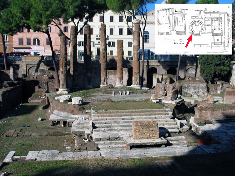
Largo Argentina (Temple B) por ortygia, en Flickr
Well... I was referring to the constructive technique, but used in more floors. In the last link I have seen this building, that although medieval, may give you an idea of what I mean. More wooden floors at the top, and roman style, but I think you will be able to see the concept.

I like a lot your work, but I agree with you this time. Perhaps this may inspire you:
@danik said:
My new video for baths of Caracalla, in this time - with water and fountain animation.
Good work and voted.
Tip: Use a UV plugin to fix the textures in the columns. I believe I used this one (http://forums.sketchucation.com/viewtopic.php?t=23725), but it may be the older version (http://forums.sketchucation.com/viewtopic.php?t=10404). I am not sure. Right click on the selected cilinder -> UV Tools -> Cylindrical map. But you should experiment a bit with different UV plugins.
When finished, consider using a 3D game engine (there are some very good free for no commercial uses), to walk inside the building, I linked somewhere in the forums a video I made with my model of the roman theatre of Orange. All the low-poly models are perfect for that.
I am resting of romans. I am working in a spanish theatre of the XVIIth century (like the english ones, Globe theatre and so). I'll link you here when I have something interesting (if you forgive me the offtopic) 
@hepf said:
To Pichuneke. Yup, "skyscrapers" are a problem. Nero established a height limit of 21 m. (seven floors) which means that before the fire you had even higher buildings. Usually bricks for the first two floors, and shaky wooden structures going up from there. That didn't happen in the central area, but it did in the shadier neighbourhoods, like the Suburra. I am fond of Gilles Chaillet's work, he usually did a good research, but he got some things wrong. In the plate I show he imagined nice gardens and gazebos on the top floor. That's a modern idea, when you have elevators. In roman times the wealthy lived on the first floor, and poorer and poorer people going up. The really miserable lived on the top floor, had to carry water and things up there through shaky stairs, and were practically condemned to death in case of fire.
I knew it, hepf. Julius Cesar was born in one of those buildings. Am I right? At least I read it in a novel. Cerdá, the spanish urbanist that made the famous "ensanche" (enlargement) of the city of Barcelona, considered that, as there were not elevators in the XIX century, the buildings would help to the integration of the different social classes. In the first floor the richest, at the top floor the poorest. But as all the neighbors would see themselves every day, they may mix (the son of the rich marries the daughter of the poor in the same building).
Some time ago I thought that the Meccano/Lego way is the best for residential buildings.
Rome Reborn does that using procedural software. And it's a pity that residential areas are not very well known, as far as I know Rome was the New York of that era, with "skyscrapers" (well, at least considering the time they were built).
Meanwhile I am working with the spanish theatres of the XVII century, I hope I can come back soon with my roman models.
And I am happy to see you again, hepf. I was wondering where were you. 
Congratulations for your work. I saw your videos some weeks ago, it's astounding 
After a year, I have managed to improve the quality of the Corinthian capital, in order to obtain a simplified one... in other words, I have made this:

To obtain this (Render and captures made with Blender)
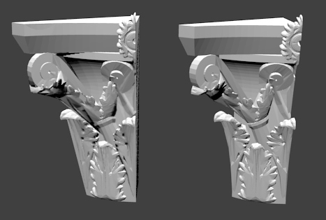
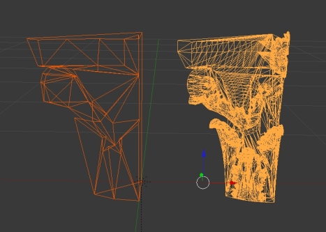
As you see, now I have a capital with one hundred times less faces than the previous one, but... I can't manage with Blender when trying to export it to Sketchup. UV doesn't import in sketchup at all (I have tried with Collada, .Obj, .3DS... no luck). What I want to do is to export it textured. The normal map in grayscale may be useful to texture a low poly version of the capital in Sketchup, as capitals are white (well, some day I could paint them with their original colours, as the marble was painted...), but at this moment I am looking for a way to export the textured capital into sketchup.
I keep fighting with this, I have used Blender 2.63.
One day I would like to export the model to a game engine.
Edit: Yes, I know that Sketchup doesn't handle normal maps, bump maps... and so on. But I want optimized versions of the columns 