Rich, I'm sure it could well be right. I got a similar figure when I did it in 2D outside of the 3D terrain. How did you calculate it?
Posts
-
RE: Calculating volume
-
RE: Fixed rate of zoom
No there isn't a setting as you describe. This is normal Sketchup behaviour therefore the trick is always to point at a face or line in order to zoom quickly. It can be frustrating sometimes however I usually use zoom extents if I get 'lost in space' to quickly get something solid to point at.
-
Calculating volume
I'm hoping someone could help with this volume query. I know that Sketchup can calculate the volume of a solid and there is also Tig's volume.rb plugin. My problem is that I'm creating some drainage ponds on a site on a 3D terrain. The attached is an example. Since it isn't flat and it's not a solid it's very difficult to enclose the pond to calculate a volume. I've tried sandboxing the outside edge to create a top which does fit but the resultant volume is wildly inaccurate. Does anyone know how I could accurately calculate the volume of the attached?
-
RE: Multiple roofs at once
Thanks for the reply Pilou. I've not had time to experiment properly. I have all the roof tools and I still don't think I can do multiple gable roofs at once. I'll combine your trick as well when i get some time. It would be good however to just have a roof tool that can do multiple roofs in the same way as single roofs and be able to make any type of roof.
-
RE: Multiple roofs at once
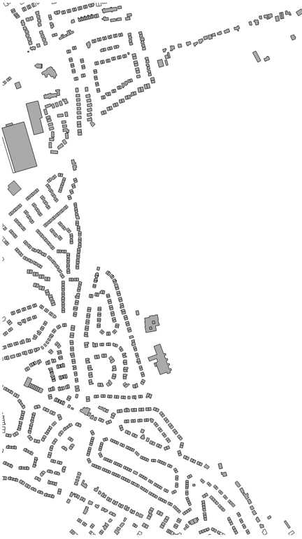
Pilou, Thanks for the reply and the tip to make individual components out of selected faces. I may be misunderstanding you, however I'm dealing with large imported base plans where the buildings can number into the thousands and all be different shapes and sizes therefore one action can't apply to all the created components. Even those that look similar can be subtly different. The example I gave was just for simplicity. The attached shows the extract it was from where it would be very time consuming to choose all the same buildings, make them components then add roofs.

-
Multiple roofs at once
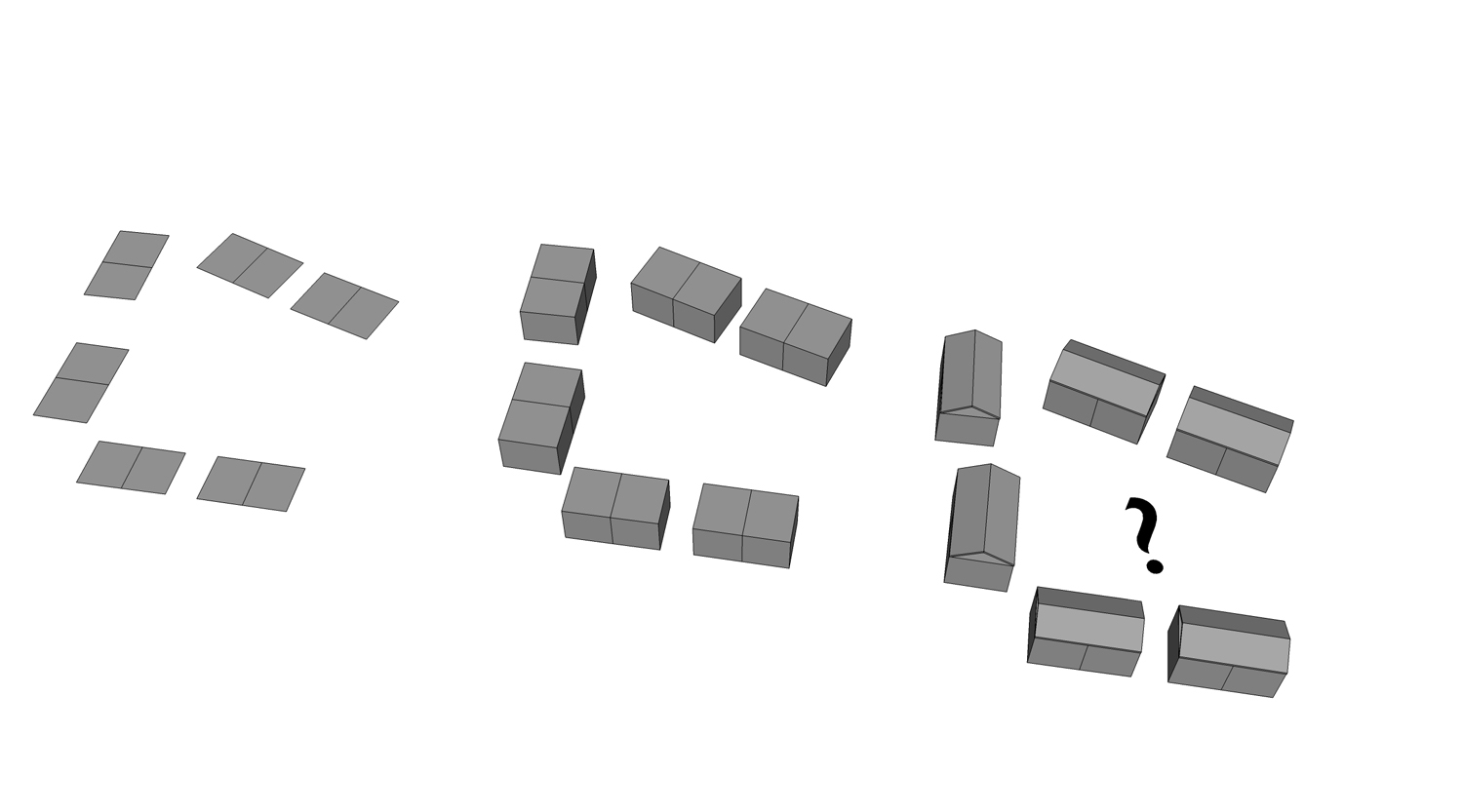
Does anyone know if there is a roof tool plugin which can create multiple gable roofs at once? When I import a map base (Ordnance Survey), I can push pull all the faces to make a simple 3D massing model of the surrounding buildings. It would be good however to go one step further and be able to select all the top faces and have them instantly create a roof to add to the extruded faces (see attached). I actually have 1001 bit tools which can creat automatic hip roofs but not gables (and these don't display as I would want them even if a hip was required). There would have to be some input which could suggest a rule for the alignment of the ridge e.g. along the longest measurement.More complex shapes might also be tricky but again a rule could either create them adapting to the geometry (taking longer) or ignore the complexity and provide a simple roof as below. I would welcome any input on this as it would be a huge time saver for large masterplans.

-
RE: Determine eye height with a click
Thanks TIG, that's exactly what I'm looking for. Great stuff!
Kenny
-
Determine eye height with a click
I know you can use the position camera tool to determine the eye height, however I'm working on a large site with complicated levels and it would be great to have a plug in that gives you the eye height with a simple click. A further useful feature would be an option to label the eye height with text with a simple click. Does such a plug in exist or is it possible to create one?
Thanks
Kenny
-
RE: Ultimate Sketchup Workstation
Thanks for all the replies everyone. It would appear that at the moment I'll just have to put up with the slow performance. Whilst I could get a slightly higher spec it doesn't look like it would be worth it in terms of any meaningful performance improvement over my current set up. For the type of work I do Sketchup is still much faster and easier than any other 3D software but on large models the actual button clicking takes seconds whilst waiting for it to respond takes hours!
It's very frustrating and throwing money at it in terms of equipment can't even address the problems. Hardware just doesn't seem to be able to keep up with how much we all push Sketchup. Or perhaps it's that Sketchup hasn't kept up with hardware in that it can't take advantage of the way hardware has gone with multi processors. Or a bit of both.
-
Ultimate Sketchup Workstation
About 18 months ago I spent a decent amount of money on a Workstation that was pretty high end at the time and probably still is. I've been fairly disappointed in it however as I work with large Sketchup files with lots of buildings, imported DWG site plans, 3d trees etc and it can really slow to a crawl. I'm well aware of switching off layers/components etc but ultimately I want to export an image with everything switched on together with shadows and sketch styles. This can take a huge amount of time adjusting views to get them right then exporting. If I want to save half a dozen views it can take the best part of a days work due mainly to the slow performance. With a small model the same work would take only a few minutes per view. It's very frustrating.
My question is has technology moved on sufficiently to notice a significant improvement if I bought a new workstation? My current specs are:
64Bit Quad-Core Processor i7 CPU 950 @ 3.07GHz, 4025 Mhz, 4 Core(s), 8 Logical Processor(s)
12GB PC3-1333 1333MHz Triple Channel DDR3 Memory
NVIDIA Quadro FX3800 1.0GB Graphics CardThese still look like decent specs but any input would be welcome if anyone can recommend a system that would handle large models with ease. Or is it the case that I should wait a bit longer until PC power gets better still and/or Sketchup becomes more efficient at handling high poly models.
Kenny
-
RE: 3d Terrain from 2d spot heights
TIG, thanks again, that's perfect! I've tried PMing you however the messsages are not appearing in my sent box. Let me know if you don't receive them soon.
-
RE: 3d Terrain from 2d spot heights
That's great TIG, thanks very much. The geometry looks fine. I've also investigated whether the original survey is available in 3D and it's not, therefore I'd be very grateful if you could do the same for the latest plan attached.
There are a couple of issues. It comes in too small (1000 times), possibly because I'm using metres and you've done it in mm. Also it would be great if it could be overlaid on the original survey base as a separate component so I know where the terrain sits in relation to the site plan features. I'me very grateful that you've taken the time to do this and I realise this will take you more time, I've sent you a PM.
Kenny
-
RE: 3d Terrain from 2d spot heights
Thanks for the further replys. TIG also many thanks for the kind offer. As it happens I've just had an updated survey sent through to me with a slightly different site area as it's just been resurveyed. I should have checked this before but I'm going to ask the survey company if they also have a 3D version, which being a recent survey I would have thought might be the case. If they don't I'll be in tough again with the latest plan so don't do anything at the moment. Thanks again for the offer and I'll let you know.
Kenny
-
RE: 3d Terrain from 2d spot heights
TIG, thanks for the LISP code but unfortunately I don't have Autocad. I do have Doublecad, will it work with that and if so how?
-
3d Terrain from 2d spot heights
I've got a 2d CAD survey with spot heights and wondered if there was a way to convert to 3d terrain. This isn't a 3d point cloud so can't use cloud.rb as the points are all on the same plane. There's a similar discussion here http://forums.sketchucation.com/viewtopic.php?f=15&t=14409&st=0&sk=t&sd=a&hilit=cloud The website with the convertor is not in existence any more and I wondered if there has been a plug in produced since then. Tig did discuss a LISP routine to convert to a point cloud which could then be converted to terrain. I don't have Autocad however. Any suggestions gratefully received!
Kenny
-
RE: Copy along path with correct alignment
Thanks for the suggestions and links everyone. I'll try them out when I have more time.
Kenny
-
Copy along path with correct alignment
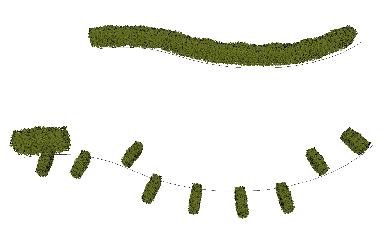
I use 'copy along a path' for objects such as trees where it doesn't really matter how they are orientated. If however you have a horizontal object such as a hedge it's important that it is aligned parallel to the path. The attached image shows what I mean. The top result is the desired one, the bottom is the actual result when you use copy along a path. The other issue is that if the component has been rescaled, copy along a path uses the original size.
I'd be grateful if anyone knows of a plug-in that will achieve the top desired result? Failing that is it possible for one to be written? This would be a real time saver if it could be achieved.
Kenny

-
RE: Roads from Centrelines
Thanks for all the suggestions. I've got these plug ins as well as Doublecad and whilst very useful it's not an automated process like the examples I linked to. I'm only looking for 2d functionality where basically I sketch out the centrelines of the roads, highlight the lines, key in parameters e.g. road/pavement width, front boundary set-back, corner radii then hit enter and it's done. I'm trying to find out if it's possible to do this as a Ruby or are the parameters too complex to be automated in the way I've described?
Kenny
-
Roads from Centrelines
I've brought this up a while back but with no solution but I thought I'd give it another go with the explosion in people involved in Ruby creation. I'm involved in a lot of masterplanning projects and when starting them I rough out routes which then develop into blocks and then insert houses, kerbs, front boundaries etc. I'm always looking at ways to reduce the time spent on this quite lengthy process and automate it as much as possible. One way would be to be able to draw out the routes with lines/arcs then select the lines and convert them automatically to roads/pavements and boundaries complete with kerb radii. I'm sure it's not easy but I've found a plug-in for Vectorworks that does a similar thing: http://www.softwarecustomizationservices.com/default.php?page=products&subPage=products/land%20planning/Default (scroll to ROWS object at the end) and also in Chief Architect: http://www.chiefarchitect.com/support/displayfaq.php?faqNumber=784
Anybody up for a challenge?
Kenny