If you have the pro version you can export dxf or dwg and try a online converter like this one http://acadconverter.chrismichaelis.com/v2012/
Mike
If you have the pro version you can export dxf or dwg and try a online converter like this one http://acadconverter.chrismichaelis.com/v2012/
Mike
Finally is all I can say. Been using SU since version 5, been a member here since 2007, learned alot, got some really cool plugins, wasn't able to make the last two basecamps, it's going to be nice to finally meet some of you.
Mike
Post the cad file if you can and I'll give it a go tomorrow.
Mike
The Smithsonian has 3D models with an online viewer and available to download, pretty neat. http://3d.si.edu/browser
Mike
Amazing!, thank you!!
Thanks fredo, looks like another amazing plugin !
@brianb said:
Charly
It still surprizes me google did not produce a simple android viewer to promote both SU program and os. Maybe Trimble will take up the challenge now! I've used autoCAD WS to view exported dwg's of my model with some success on nexus 7. Looking at Sightspace on the playstore there doesn't seem to have been any great take up compared to other programs and has a mixed bag of reviews. Anyone out there using it and on what device?
Brian
I've been using SightSpace on my Samsung Galaxy Slll for awhile. My two cents,it does a decent job of viewing small to mid size models,panning and rotating smoothly,though some curved and/or smoothed surfaces sometimes appear faceted. Also have not had much success with the augumented reality mode.
Mike
Thanks for the reply. An example of linework code would be BC + and BC -, where BC is the description and the +/- are the linework codes telling the line to start or end here.
Mike
BUMP
I'm not asking anyone to write this, at least not for free, just want to know if it's possible with ruby. Would like to take it a step further and have the linework connecting the points drawn automatically based on the description and a "lineworh code". Possible?, too much trouble? Should I just stick with Civil3D?
Mike
....would it be possible to have a plugin that can import a csv or txt file containing a point #, northing,easting (in state plane coordinates, with an option for navd27 and navd88),elevation, and description. I imagine I would have to geolocate the model first and the plugin would require some sort of converter to go from state plane to lat/long ? Thanks for any replies.
Mike
@solo said:
Mike,
I noticed in my account page at e-on that I have 2 activations, I'm guessing one can use it on two machines.
Thanks solo, wish someone from E-on would confirm this, seriously considering purchasing but only being able to install on one machine would probably be a deal breaker for me.
Mike
@nicholas phelps said:
You don't need the Publisher to export stills or animations. If you right/long click on the Play movie icon, this brings up the export movie icon. It's also on the Timeline bar.
Thanks, good to know, what about my licensing question?
Mike
Nicholas,
I have two questions that I couldn't find definite answers to on the Eon site. 1) Is it possible to install on desktop AND laptop with one license ? 2) Without purchasing Publisher, what output do you get from Lumenrt ? Thanks
Mike
@jgb said:
As a result, it is IMHO a very high end hobbyist "semi" CAD tool and a low/medium end professional rapid CAD tool
Exactly, SU in its current state is not much use to Trimble. We collect so much field data now, theres no way to bring all that into SU. Everything is brought into Civil 3D where an existing conditions base is made and design goes from there, then its brought back into Trimble where its staked on the ground. I think Trimble wants to keep this whole process "in house". Also theres so much competion in field data collection and mapping, Astech, Lieca, Sokkia, Javad, etc., but they all depend on other software such as Civil or Carlson. It would be a great selling point for Trimble if they could offer the "complete" solution. So I think we'll see big changes in SU, starting with Trimbles first version, which IMO I don't think we'll see till late 2013. I expect to see a coordinate system, drawing real arcs using arc length, chord length, radius. I think Trimbles biggest challenge is making SU sophisticated enough for what they need but simple enough to not have to retrain current autodesk users and current SU users. My 0.02....
Mike
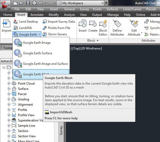
Don't even have a guess as to what may happen to the free version. I was at my local Trimble distriber last week and according to them Trimble is throwing lots of $ and resourses at SU development though they didn't give me any specifics if they had any. I do think Trimble will move SU from a "hobbyist" software to a "pro" modeler and cad package to eventually compete with Autodesk. Some things seem to be pointing that way, Civil 3D 2011 & 2012 had functions to import Google Earth images, contours, and/or meshes (see pic), Autodesk Labs even had a plugin for Autocad to geolocate a 3D model similiar to how SU does it. That functionality is now gone from Civil 3D 2013, the Autocad plugin is gone, there is a new one for Civil 3D that uses Bing maps. Just saying....
Mike
o2bwln, no its not my design, modeled from the architects plan and I do agree.
Mike
Two quick renders while I wait for the site and landscape plans. C&C always appreciated.
Mike