[Plugin][$] TopoShaper - v2.7b - 30 Jan 26
-
The information on TopoShaper is maintained on the Plugin Home Page of TopoShaper. This is also where you can download the RBZ file.

-
LibFredo6: v14.3b or above
-
Sketchucation ExtensionStore: v4.4.0 or above (for licensing)
-
Sketchup version: SU2017 and above
-
Platform: Windows and Mac OSX
-
Usage: Licensed under Sketchucation SCFLicense
-
Free Trial period (full features): 30 days from first usage
-
Perpetual license (3 seats): $12
-
Part of Fredo6Bundle2022 license (8 plugins): $40
To purchase the license of TopoShaper or the Bundle of 8 plugins, go to this page and sign in.
If you land on this page and are unfamiliar with how to install Sketchup Extensions such as LibFredo6 or how to register on Sketchucation, please watch this video or refer to the Plugin page of LibFredo6.

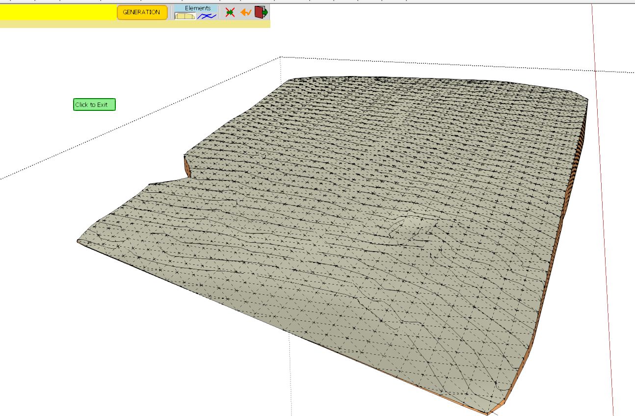
TopoShaper generates Terrains:
- from a group of iso-contours, that is, contours which have a constant or quasi-constant altitude. The Terrain is generated as a QuadMesh
- from a Cloud of Points (given as a group of Guide points). The Terrain is generated as an adaptive Triangular mesh.
TopoShaper::IsoContours
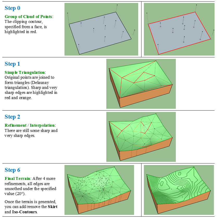
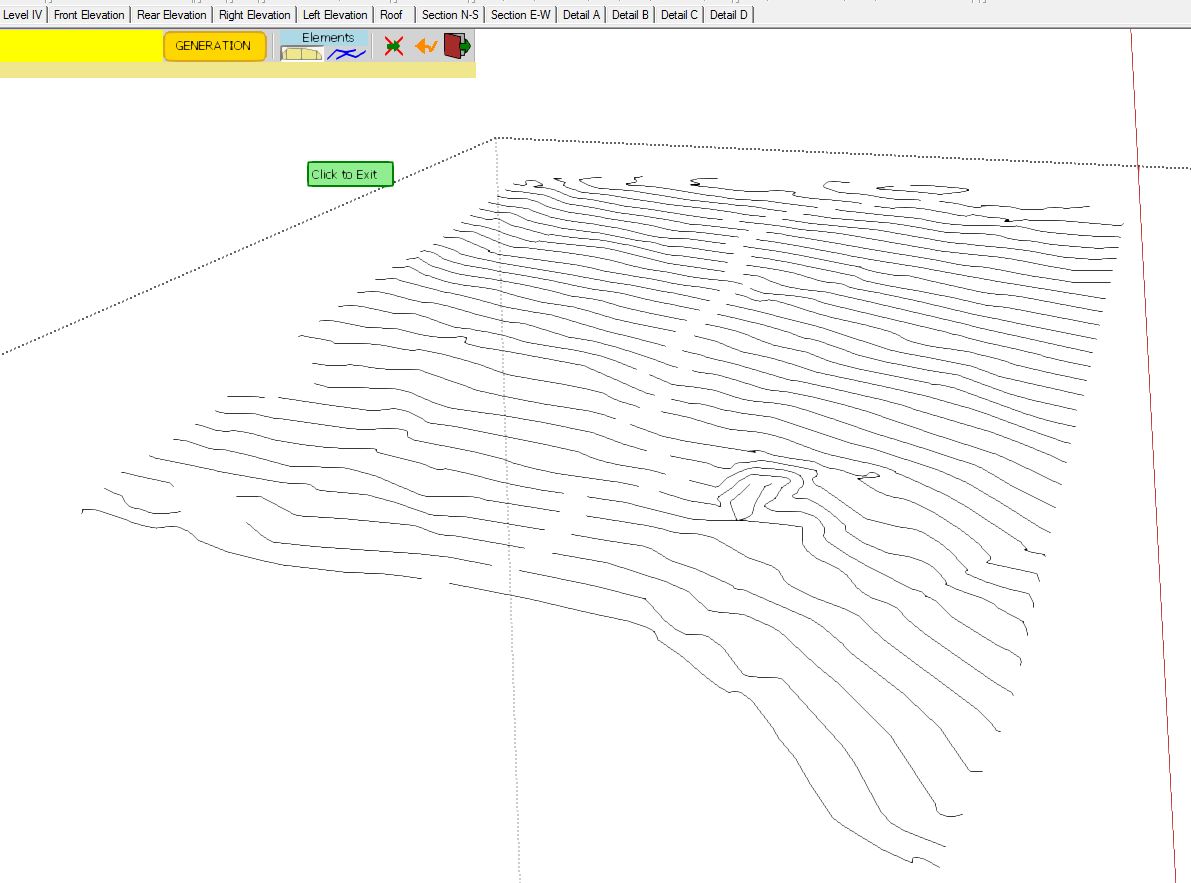
TopoShaper::IsoContours works in 4 steps:- Selection of Contours, usually by pre-selecting a group containing the contours before launching TopoShaper
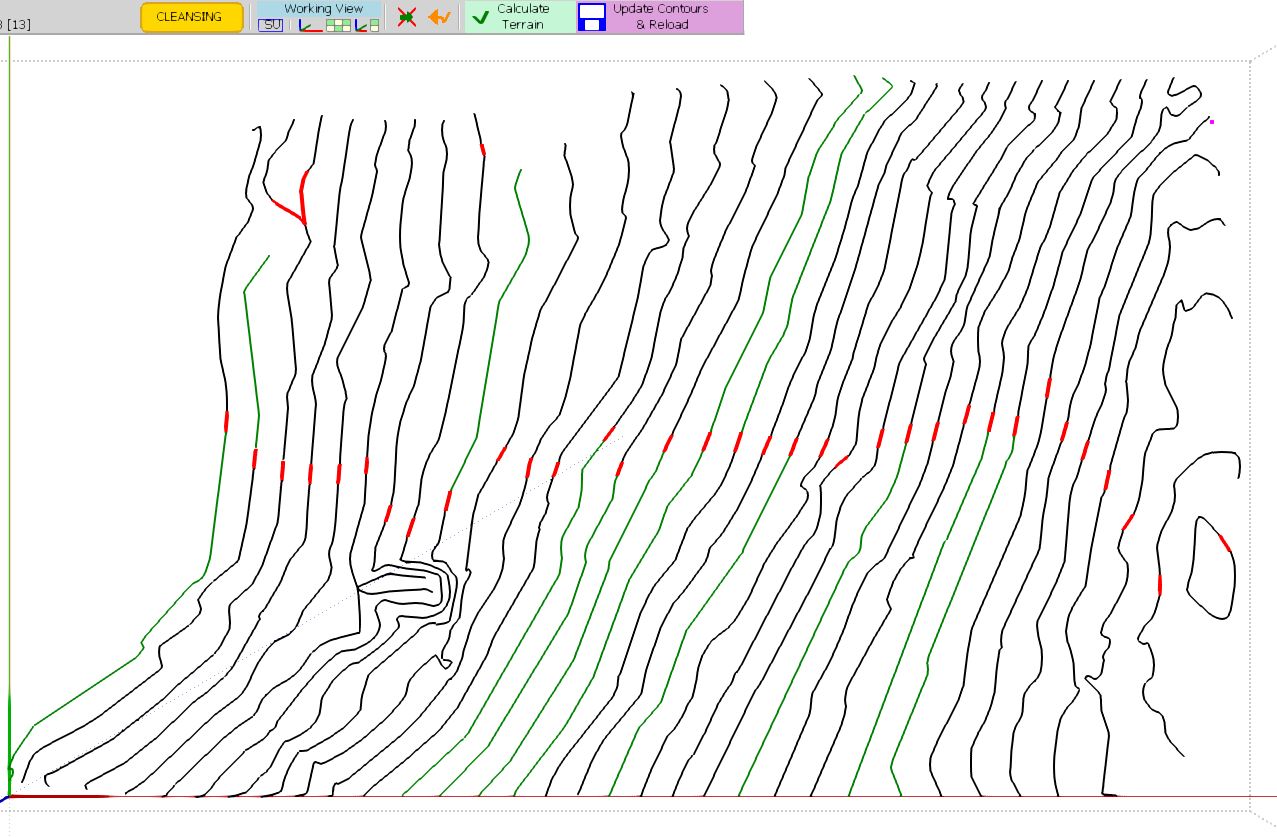
- Cleansing Contours, which can be useful when contours are imported as DXF/DWG files. In version 1.0, the Cleansing covers the exclusion / inclusion of contours, their simplification, automatic and manual junctions and removal of small hooks. There is an Altitude Editor to set or modify the altitude of the indivdual contours.
- Calculation of Terrain and Preview. The Terrain is computed on a rectangular grid. You can change the grid resolution and have option to configure the hilltops and basins.
- Generation of the Terrain Surface as a quad-mesh surface enclosed in a group. Optionally you can include the Skirt and the contour map, with or without altitude labels.
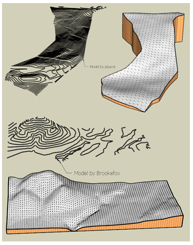
The idea of this plugin was developed after some discussions in another thread initiated by Brookefox. You will also find there some models of contours to exercise TopoShaper.
Here are [url=http:http://sketchucation.com/forums/viewtopic.php?f=323&t=52039&p=513310#p513310]a few sample contours models[/url] from some kind Community users. This will help you to get familiar with TopoShaper::IsoContours.
TopoShaper::PointsCloud
TopoShaper::PointsCloud takes a group of Guide Points. If it encloses faces, they will form the Clipping Contours. Otherwise, the default Clipping contours are taken as the convex hull of the points.
The Terrain is generated as an adaptive triangular mesh, where triangles are more dense where the altitude changes. The algorithm is iterative, by refinement of the triangulation until the Terrain is 'smooth' enough (specified by a smoothing angle). Points are part of the mesh (i.e. the terrain passes thorugh the original points).
Here are some sample models to exercise the functionality (in SU6 format).
TopoShaper Points Cloud - Sample models - SU6.skp
Toposhaper - Iso-Contours - User Manual - English - v2.0 - 22 Dec 14.pdf
Toposhaper - CloudPoints - User Manual - English - v2.0 - 22 Dec 14.pdf
Just drop the attached PDF files into the DOCUMENTATION_Dir sub-folder to have it accessible from within Sketchup.There is also a service API for calculating silently a Terrain from isocontours. Here is the documentation with examples:
TopoShaper - Isocontour API.pdf
A comprehensive video by TutorialsUp
https://www.youtube.com/watch?v=zt2-q3Zb7JE&t=20s&pp=ygUTc2tldGNodXAgdG9wb3NoYXBlcg%3D%3DOverview of Isocontour terrains
https://www.youtube.com/watch?v=2ru5MnE-D_Q&pp=ygUTc2tldGNodXAgdG9wb3NoYXBlcg%3D%3DAltitude Editor
https://www.youtube.com/watch?v=-n6kL6YcTtA&pp=ygUTc2tldGNodXAgdG9wb3NoYXBlcg%3D%3DTerrain from Points Cloud
https://www.youtube.com/watch?v=bc1prnzkAXs&t=12s&pp=ygUTc2tldGNodXAgdG9wb3NoYXBlcg%3D%3D -
-
BOOOOM! Goes the Dynamite!
-
Awesome!
 Can't wait to try this out.
 -
Thanks fredo, looks like another amazing plugin !
-
Thank you so much Fredo! It's amazing and exactly what we need working with topography.

-
Another classic from you, thank you!
-
WOOHOO. Pass the champagne! I just got a project to run on this one. A nice STEEP slope.
Thanks a million times, Fredo.
-
@pbacot said:
WOOHOO. Pass the champagne! I just got a project to run on this one. A nice STEEP slope.
Thanks a million times, Fredo.
Thanks for the toast! If you encountered problems on your new model, do not heistate to send it to me so that I can investigate.
Fredo
-
Wow! This looks great. Can't wait to try it out!
-
wow, when Master Fredo comes down from the mountain (literally in this case), he always come back with some incredible treasure...
awed and grateful thanks!


Edit: sorry folks, hope no one minds if i attach a couple of custom icons.


alternative 16x16

-
Yet another magnificent plugin to greatly enhance SketchUp's usability. And again to the highest standards!
How easy it is to repair (automatically AND manually) faulty terrains! Amazing!
Fredo, you outdid yourself once again!!!
 (initial Donation already made...)
@CadFather:
thanks for the shiny buttons! -
Just had a look through the manual for the full breakdown of this plugin - ZOMG! This must have taken time to develop! Why you don't release this as a commercial plugin is beyond me.
I would encourage people to use the Donate button to reward Fredo for the amazing effort on , not only this plugin - but his whole suite!
-
@thomthom said:
Just had a look through the manual for the full breakdown of this plugin - ZOMG! This must have taken time to develop! Why you don't release this as a commercial plugin is beyond me.
I would encourage people to use the Donate button to reward Fredo for the amazing effort on , not only this plugin - but his whole suite!
I was thinking the same thing... Awesome Power.
-
BTW... Where is his donate button?
fast and powerful... 60 seconds.
-
Fredo donate link is in the tools menu
-
@cadfather said:
Edit: sorry folks, hope no one minds if i attach a couple of custom icons.
Thanks very much. I am always impressed by your quality of designer.
If you don't mind, I'll integrate them into the next release as the standard icon.
Fredo
-
@thomthom said:
Just had a look through the manual for the full breakdown of this plugin - ZOMG! This must have taken time to develop! Why you don't release this as a commercial plugin is beyond me.
It is some work indeed, but I do it on my spare time. This is why it takes so long (6 months elapsed). And as usual, this is 80% GUI and 20% algorithmics.
Fredo
-
the donate button in Sketchup sends me to a paypal link that seems to be in French and won't let me login. I'll just send it to the email address.
I posted those pictures and didn't know similar ones were already in the instructions. I'm SketchUp famous now... Such an awesome feature to "fix" the topo map.
-
NEW RELEASE: TopoShaper v1.0b - 26 Apr 13
This is an adjustment release with afew evolutions:
- Integrated the Spanish (oxer) and Chinese (guanjin) transaltions. Thanks to both.
- Integrated the toolbar icon proposed by Cadfather. Thansk very much too
- Added the generation of 2D contour map geometry
- Fix an issue with architectural units in the dimension dialog box
See main post of this thread for Download.
Fredo
-
..my honour Fredo. anytime, just ask. (and thanks again!)


Advertisement