[Plugin][$] TopoShaper - v2.7b - 30 Jan 26


-
@tt_su said:
...To get real value out of them you really need to be using the BugSplat backend.
 Haha so it's quite beyond me at the moment...thanks!
 -
thank you so much for this amazing plugin.. life saver i must say..
-
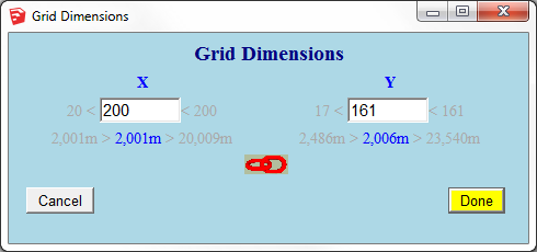
one small thing... i think the info about the grid spacing should be mirrored to correspond with the division number above and the arrows.
But once again: fantastic plugin!!! Very helpful! Thanks!

-
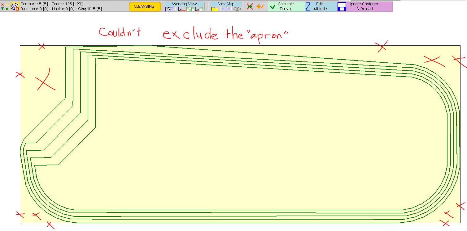
Hi,
I have a problem with this file (originating from a DWG import).This represents a drying pond.
The terrain generated extended outside the top-most contour (each contour is on its own layer).
I also tried to manually remove the "apron" but was unsuccessful.
-
Toposhaper is really great but not enough powerfull or precise for big landscape datas !
I had to find another solution for those big projects
http://rendering.ru/ru_en/splineland.html
This is the only valuable and reliable solution I found.
Fredo, if you could do something like that for future Toposhaper updates... just a dream...

-
Panga,
This Splineland application looks really great and powerful, at least from the 2 videos posted on the site
and it can also handle terrain given by elevation points only
This is definitely more adapted for large terrains and professional needs.
I had a few evolutions on my roadmap for TopoShaper, but nothing easy or fast to do, though possible.
-
Refinement of mesh, by subdivision. This has the drawback to break the quads nature of the generated terrain, but I agree this is required to handle sharp reliefs
-
Insertion of roads and platforms may come, but from another plugin (actually derived from VisuHole)
-
Building terrains from individual elevation points cloud is also possible, but the calculation is quite long as it requires an optimization algorithm
-
Triangular mesh may also be more adapted in many situations. It requires constrained Delaunay triangulation which is beyond the performance of Ruby for large terrains (unless the Sketchup team publishes one in Sketchup, like Triangles).
That's anyway low priority because I am not sure that many professional landscaping designers would be using Sketchup and TopoShaper versus dedicated programs line Splineland.
Fredo
-
-
Hi Fredo,
Splineland is as good as those videos shows, very reactive and powerfull for big landscape datas.
I fully understand your point of view and I know (unforntunatly) sketchup's limitations that prevent from having such a tool in sketchup. That's why we claim for High-poly support in sketchup for so many years...
The good thing is I can import the mesh done with splineland in sketchup, but I'm forced to use 3DSmax...So such a tool in sketchup would be very helpfull...no not very, but very very very very very helpfull !!
So this is more a message to sketchup dev team : you won by the past so many users with landscape capabilities of sketchup, but today landscape datas and project are always more demanding and heavy, so maybe it's time to take it seriously !
Regards, and again thanks to Fredo for your wonderfull tools ! You, ruby devs are rocking the sketchup world !
Edit : Just in case the sketchup dev team don't know how to improve sktechup terrain tools, come to ask me, I spent so many hours trying to find solutions and I'm using it everyday !!
-
NEW RELEASE: TopoShaper v1.2a - 19 Oct 14
This release is required for the support of usernames with non-ascii characters in Sketchup 2014
See main post of this thread for Download of TopoShaper.
Fredo
-
NEW RELEASE: TopoShaper v2.0 - 30 Dec 14
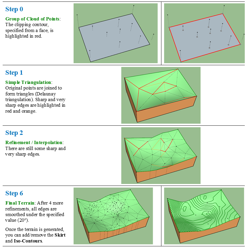
This major release introduces a new functionality: generation of Terrain from a Cloud of Points.
The terrain is generated by progressive triangulation / interpolation as an adaptive triangular mesh until it is smooth enough, as specified by a smoothing angle. It also allows to define clipping contours for the terrain.
[flash=640,480:1lak7gxg]http://www.youtube.com/v/bc1prnzkAXs&hl[/flash:1lak7gxg]
See main post of this thread for Download of TopoShaper.
Fredo
-
Wow! This is great.
-
Awesome! Thank you.
Did you keep track of the number of hours you spent developing this? I'm guessing it was massive.
Regards, John
-
 i just have a question... WHO is Fredo6!!!
 this stuff should be in the evening news!
Thanks Fredo
-
I just used this on imported contours that I had reworked in CAD beforehand. Toposhaper was the smoothest part of the whole operation. Looking good. If you need another real world case, I can send it. I also made some simple fill outlines from the building and edges from the mesh. Ran Toposhaper to create those as well. Thanks Fredo!
-
And at the end apply a Color by Z (By Chris Fullmer or Sdmitch) and you will have a perfect tool for Topography!

-
Fantastic update, thank you!
-
@pbacot said:
I just used this on imported contours that I had reworked in CAD beforehand. Toposhaper was the smoothest part of the whole operation. Looking good. If you need another real world case, I can send it. I also made some simple fill outlines from the building and edges from the mesh. Ran Toposhaper to create those as well. Thanks Fredo!
I am indeed interested by this real world case!
Thanks
Fredo
-
Fredo, what can I say...and my parents were telling me that Santa dit not exist !! I'll try it right now and give you some feedback, but I'm already give you my BRAVO !
Regards.
-
Ahhh, toposhaper from cloud points! Just what I needed when I asked this question:
Thank you Fredo. You are genius!!!
-
I too am happy to send you real world case, Fredo. I have a few good surveys that I can send you....
One question re: cloud points: when a survey file is sent you to the points are provided as just that; points. Do I have to somehow convert them to guide points? And if so, how??
-
super plugin congratulations Fredo6,
is it possible for you to improve the plugin by adding the stamp function because the basic function of Sketchup does not function well with a non-flat platform.
we could from the current stamp function by adding a regular slope adjustment feature. (angle parameter).
Because of Sketchup stamp function offers a parrallel offset.
this feature could be ideal for earthmoving ground with regular slope even allows pente.it's draw on autocad perfectly calibrated slope and sutout non parrallel.
excuse me for my English I am french
thank you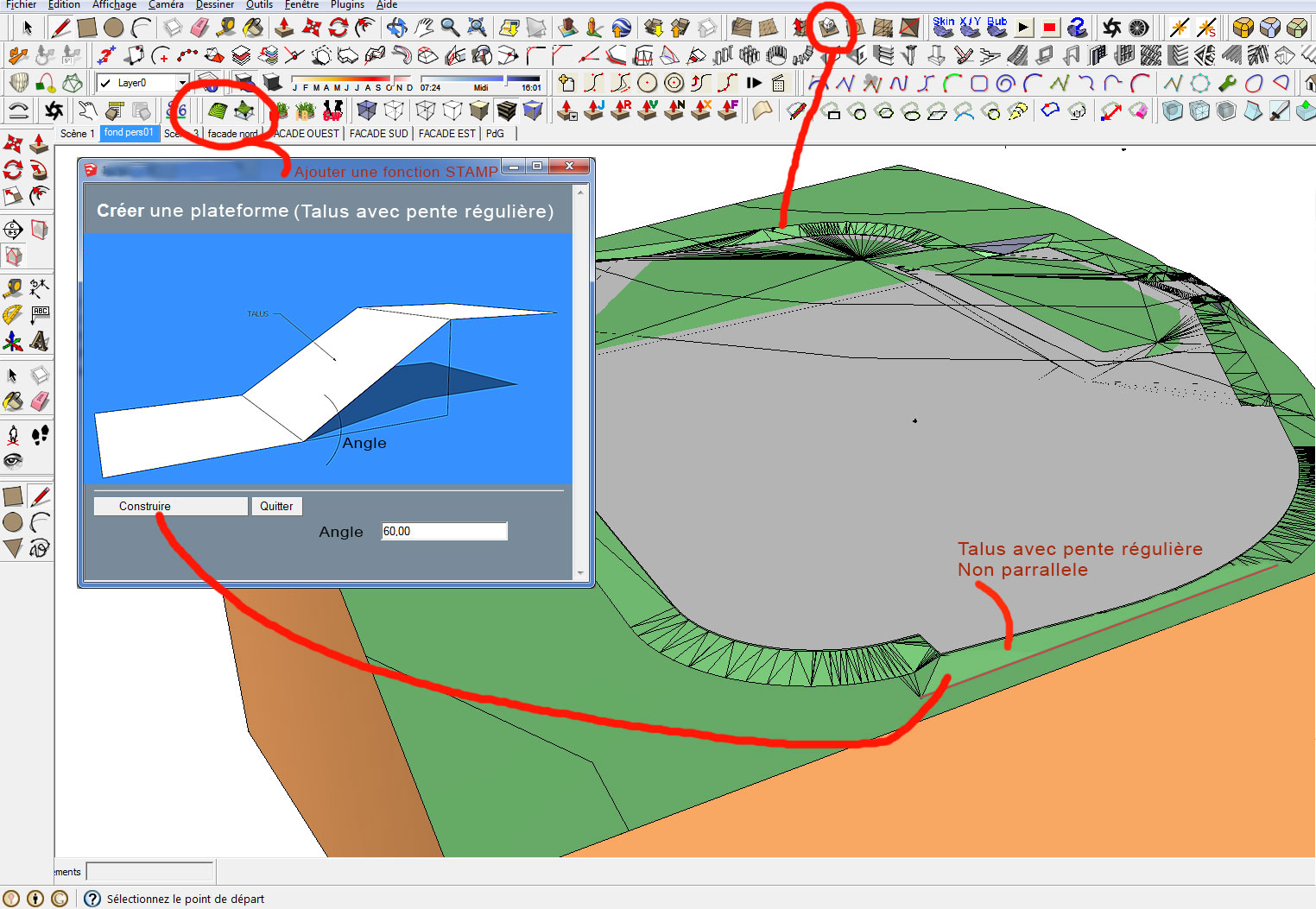
Hello! It looks like you're interested in this conversation, but you don't have an account yet.
Getting fed up of having to scroll through the same posts each visit? When you register for an account, you'll always come back to exactly where you were before, and choose to be notified of new replies (either via email, or push notification). You'll also be able to save bookmarks and upvote posts to show your appreciation to other community members.
With your input, this post could be even better 💗
Register Login


Advertisement