• Login
sketchucation logo sketchucation
  • Login
๐Ÿค‘ SketchPlus 1.3 | 44 Tools for $15 until June 20th Buy Now

Terrain from contours - improve on native 'from contours'?

Scheduled Pinned Locked Moved SketchUp Discussions
sketchup
99 Posts 18 Posters 19.5k Views
Loading More Posts
  • Oldest to Newest
  • Newest to Oldest
  • Most Votes
Reply
  • Reply as topic
Log in to reply
This topic has been deleted. Only users with topic management privileges can see it.
  • F Offline
    fredo6
    last edited by 18 Jan 2013, 22:02

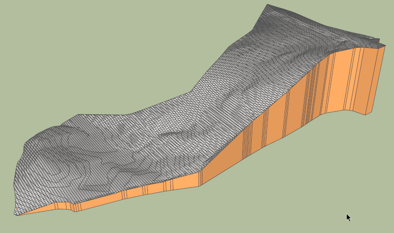
    Here is the terrain with a much higher definition 200 x 88, so around 35,000 triangles generated. Takes longer of course, but does not bring a lot more details compared with the low and medium definitions terrains.

    DN house contours - pbacot - High Def.skp

    House pbacot 6 Jan 13 - high def.png

    Fredo

    1 Reply Last reply Reply Quote 0
    • F Offline
      fredo6
      last edited by 19 Jan 2013, 23:04

      @utiler said:

      Thanks Fredo, so if I triangulated points with your triangulate plugin then ran toposhaper I'd get this result!!!!???

      With TopoShaper you really need to have contours as curves, not a set of altitude points. This is because the Terrain construction uses contours to delimit the zone of influence on points comprised between contours.

      With a set of altitude points, the algorithm would be more based on Skinning, with Bezier or Nurbs methods, which is another kind of script (I can do it, but it would definitely not be very fast with Ruby only).

      So, all you need is the contours and then run Toposhaper, as shown in previous videos and the video below

      TopoShaper pbacot on House 50.gif

      Fredo

      PS: As far as I remember, I have not written (yet) a "triangulate plugin".

      1 Reply Last reply Reply Quote 0
      • P Offline
        Panga
        last edited by 23 Jan 2013, 07:02

        @unknownuser said:

        With TopoShaper you really need to have contours as curves, not a set of altitude points. This is because the Terrain construction uses contours to delimit the zone of influence on points comprised between contours.

        With a set of altitude points, the algorithm would be more based on Skinning, with Bezier or Nurbs methods, which is another kind of script (I can do it, but it would definitely not be very fast with Ruby only).

        Fredo,

        During my works I found a workaround with altitude points. I draw a high vertical line on each point (as they're usually components, it's a very fast operation), this way the sandbox is using contours instead of points, ignoring the bottom point of each line. Will this method work with your plugin ?

        1 Reply Last reply Reply Quote 0
        • F Offline
          fredo6
          last edited by 23 Jan 2013, 19:33

          @panga said:

          During my works I found a workaround with altitude points. I draw a high vertical line on each point (as they're usually components, it's a very fast operation), this way the sandbox is using contours instead of points, ignoring the bottom point of each line. Will this method work with your plugin ?

          Unfortunately, it won't work. TopoShaper really needs contours to drive the interpolation. Keep in maind that with only altitude points, there are multiple solutions because you cannot isolate zones just with scarced points.

          Fredo

          1 Reply Last reply Reply Quote 0
          • U Offline
            utiler
            last edited by 24 Jan 2013, 01:09

            Fredo, I assume Toposhaper is a work in progress and hasn't been released yet? I can't find it for download...

            Cheers,

            purpose/expression/purpose/....

            1 Reply Last reply Reply Quote 0
            • F Offline
              fredo6
              last edited by 24 Jan 2013, 22:14

              @utiler said:

              Fredo, I assume Toposhaper is a work in progress and hasn't been released yet? I can't find it for download...

              Cheers,

              Correct, it is work in progress. However, I think I have done most of the algorithmics now and should be able to release a first simple version soon.

              In the meantime, I am still interested in getting models of contours to test the plugin.

              Fredo

              1 Reply Last reply Reply Quote 0
              • U Offline
                utiler
                last edited by 25 Jan 2013, 00:35

                OK, do you want them in DWG or SU? I'll send a few through....

                purpose/expression/purpose/....

                1 Reply Last reply Reply Quote 0
                • P Offline
                  pbacot
                  last edited by 25 Jan 2013, 03:41

                  I'm "cooking" one up in Sandbox right now. I'll send the file when it gets done. Taking about 10 min. to do "from contours". It's a nice one with hills and saddles.

                  MacOSX MojaveSketchUp Pro v19 Twilight v2 Thea v3 PowerCADD

                  1 Reply Last reply Reply Quote 0
                  • T Offline
                    twestover
                    last edited by 31 Jan 2013, 00:03

                    Will the plugin work with an already triangulated surface?

                    Say I have imported and triangulated a set of XYZ data, and wish to turn it into a solid group like your final product, with vertical sides and a horizontal bottom. Is that possible?

                    1 Reply Last reply Reply Quote 0
                    • U Offline
                      utiler
                      last edited by 31 Jan 2013, 06:02

                      Fredo, would you like contours in DWG or SU?

                      purpose/expression/purpose/....

                      1 Reply Last reply Reply Quote 0
                      • F Offline
                        fredo6
                        last edited by 31 Jan 2013, 07:44

                        @utiler said:

                        Fredo, would you like contours in DWG or SU?

                        I prefer SU as I am not familiar with CAD and Archi software (I don't know DWG format).

                        Thanks in advance

                        Fredo

                        1 Reply Last reply Reply Quote 0
                        • pilouP Offline
                          pilou
                          last edited by 31 Jan 2013, 09:31

                          @unknownuser said:

                          I prefer SU as I am not familiar with CAD and Archi software

                          Except one! SU Itself ๐Ÿ˜‰

                          Frenchy Pilou
                          Is beautiful that please without concept!
                          My Little site :)

                          1 Reply Last reply Reply Quote 0
                          • U Offline
                            utiler
                            last edited by 2 Feb 2013, 00:34

                            Here's a few contour Skippy's, Fredo.

                            Survey01 - contours or a regular residential site of about 800sqm with a 15m fall. Contours at 250mm....

                            survey01.skp

                            Survey02 - contours over a commercial development site of about 2800sqm. Contours at 200mm increments with minimum grad.

                            survey02.skp

                            purpose/expression/purpose/....

                            1 Reply Last reply Reply Quote 0
                            • F Offline
                              fredo6
                              last edited by 2 Feb 2013, 21:43

                              Andrew

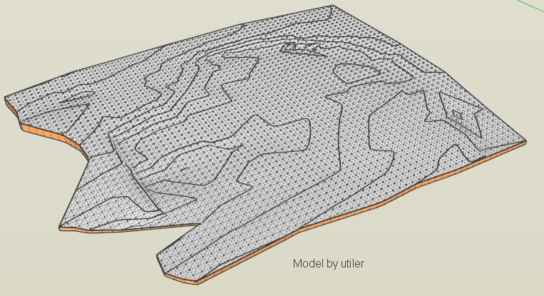
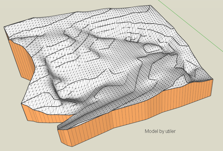
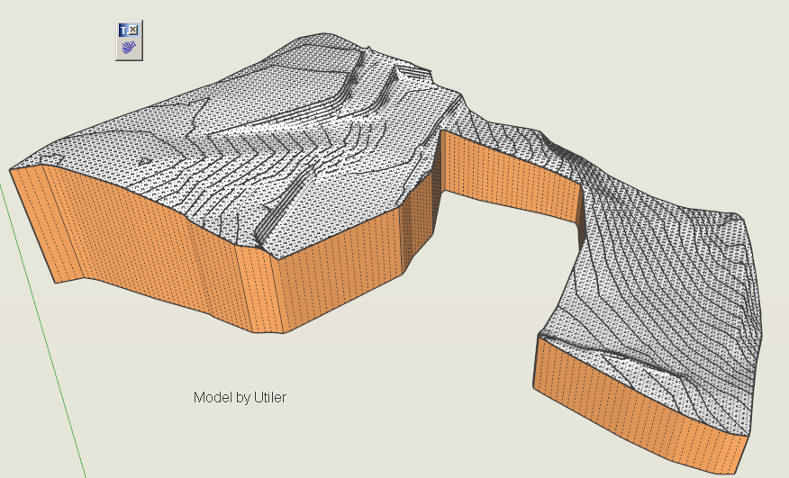
                              First of all, thanks very much for posting these 2 samples. They are extremely useful for fine tuning the algorithms.

                              I have problem about the calculation of the concave hull for the first one, but here is the second one, in 2 flavors:

                              • the original altitude (which are very flattish)
                              • the exaggerated altitudes which help me to better check the calculations

                              utiler_survey02.skp

                              Utiler Survey02 by TopoShaper.png

                              Utiler Survey02 by TopoShaper max.png

                              Fredo

                              1 Reply Last reply Reply Quote 0
                              • KrisidiousK Offline
                                Krisidious
                                last edited by 2 Feb 2013, 22:36

                                subscribed... ๐Ÿ˜ฒ

                                By: Kristoff Rand
                                Home DesignerUnique House Plans

                                1 Reply Last reply Reply Quote 0
                                • U Offline
                                  utiler
                                  last edited by 3 Feb 2013, 01:51

                                  No problem, Fredo, I'm not surprised at issues with the first one as it was a survey of a site with an existing residence on it which prevented a uniform data to be taken...

                                  What you've done with the other one looks good! Can't wait to see how this plugin ends up. I'll see if I can dig out some other survey plans off file and convert them for you.

                                  ๐Ÿ‘

                                  purpose/expression/purpose/....

                                  1 Reply Last reply Reply Quote 0
                                  • F Offline
                                    fredo6
                                    last edited by 12 Feb 2013, 23:04

                                    @utiler said:

                                    No problem, Fredo, I'm not surprised at issues with the first one as it was a survey of a site with an existing residence on it which prevented a uniform data to be taken...

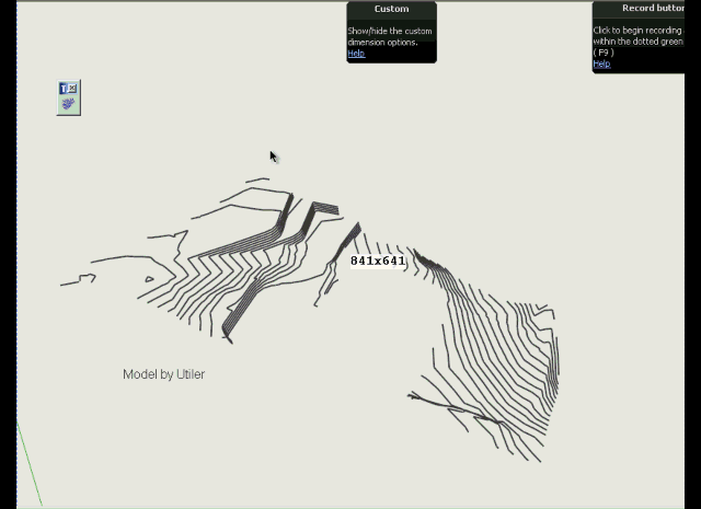
                                    I evolved the algorithm for calculating the concave hull on your complex model and could obtain a result on your model, without any change, here attached.

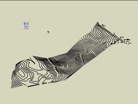
                                    A lot of the problem come from the small terminations hooks in several contours, like illustrated on the picture below
                                    TopoShaper small hooks.png

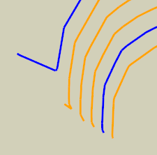
                                    The issue with terrain construction is that you need to have a correct hull in order to determine the spatial distribution of the influence of the contours.

                                    utiler_survey01.skp

                                    TopoShaper Utiler Survey 01.png

                                    TopoShaper Utiler Survey 1.gif

                                    Fredo

                                    PS: I hope to finish a first version in 2-3 weeks time, as I have actually very few moment available currently

                                    1 Reply Last reply Reply Quote 0
                                    • EarthMoverE Offline
                                      EarthMover
                                      last edited by 12 Feb 2013, 23:30

                                      Can't wait! Thanks Fredo!

                                      3D Artist at Clearstory 3D Imaging
                                      Guide Tool at Winning With Sketchup
                                      Content Creator at Skapeup

                                      1 Reply Last reply Reply Quote 0
                                      • U Offline
                                        utiler
                                        last edited by 13 Feb 2013, 01:15

                                        that is looking very sweet, Fredo!!!! Can't wait as well!!!

                                        purpose/expression/purpose/....

                                        1 Reply Last reply Reply Quote 0
                                        • KrisidiousK Offline
                                          Krisidious
                                          last edited by 13 Feb 2013, 02:48

                                          here's a topo I just got from a survey company... if you need tests.


                                          HANNA-TOPO.dwg

                                          By: Kristoff Rand
                                          Home DesignerUnique House Plans

                                          1 Reply Last reply Reply Quote 0
                                          • 1
                                          • 2
                                          • 3
                                          • 4
                                          • 5
                                          • 4 / 5
                                          • First post
                                            Last post
                                          Buy SketchPlus
                                          Buy SUbD
                                          Buy WrapR
                                          Buy eBook
                                          Buy Modelur
                                          Buy Vertex Tools
                                          Buy SketchCuisine
                                          Buy FormFonts

                                          Advertisement