[Plugin] Coords Text Tag from Datum
-
@tig said:
So.... is it 'broken' ?
And if it is what do I [we] need to do to fix it ??
No, it works perfectly. Just swap the Longitude and Latitude texts in the dialog. This way it is misleading because we need to enter the values swapped.
This (line 799-803):
<span class="syntaxdefault"> if xyunits</span><span class="syntaxkeyword">==</span><span class="syntaxstring">"Latitude_Longitude"<br /></span><span class="syntaxdefault"> p0</span><span class="syntaxkeyword">=</span><span class="syntaxstring">"Longitude; "<br /></span><span class="syntaxdefault"> p1</span><span class="syntaxkeyword">=</span><span class="syntaxstring">"Latitiude; "<br /></span><span class="syntaxdefault"> xyus</span><span class="syntaxkeyword">=</span><span class="syntaxstring">"LL"<br /></span><span class="syntaxdefault"> else<br /> </span>should be
<span class="syntaxdefault"> if xyunits</span><span class="syntaxkeyword">==</span><span class="syntaxstring">"Latitude_Longitude"<br /></span><span class="syntaxdefault"> p0</span><span class="syntaxkeyword">=</span><span class="syntaxstring">"Latitude; "<br /></span><span class="syntaxdefault"> p1</span><span class="syntaxkeyword">=</span><span class="syntaxstring">"Longitude; "<br /></span><span class="syntaxdefault"> xyus</span><span class="syntaxkeyword">=</span><span class="syntaxstring">"LL"<br /></span><span class="syntaxdefault"> else<br /> </span>"Latit
iude" is misspelt there anyway (good it was not in the code - although then it would have turned out at least - and I could hardly find it as I did not notice the misspell first and was also searching for "Latitude" in NP++) so it could bear an update.

-
That solved that problem, Gaieus.

Now to try this on the ‘Import Coords-Tags from CSV’ tool.
Note the coordinates entered in the dialog are the reverse of those in Model Info-Location
Yet, the LL-Tag it creates is correct.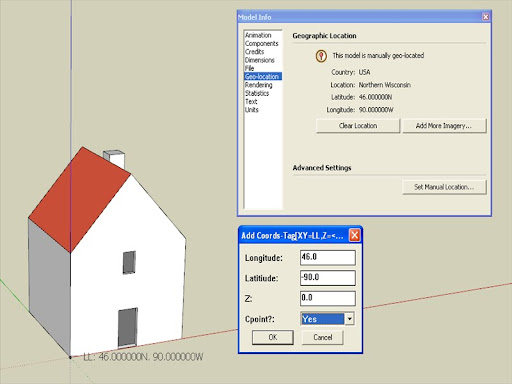
-Geo
-
Oh, I am really glad. When I was torturing TIG along this whole topic until we got where the plugin is, I mainly concentrated on the other aspects of it (custom, ortho-co-ordinates) as Didier by then had come out with his LatLong tool and in this plugin here it was just an "extra" for me (but of course, important one) so did not notice this little glitch.
Anyway, I hope you enjoy it as much as I do (and of course, many thanks to TIG again)

I think in that Help Forum topic I overcomplicated the thing with the PhotoMatch thing as the guy does not seem to need it as accurately.
-
OK, so I went along and did the changes in the code I wrote above and success; it works perfectly!
-
Here's an update http://forums.sketchucation.com/viewtopic.php?p=284829#p284829
It should now work ! as Gaieus explained the prompts were wrong .
.
At least I've got him to delve into the bowels of a script AND fix it himself!!
We'll make a scripter of you yet Csaba!!!I fixed the typo in the 'Add' dialog prompts' text.
I've also add +/- clues in them to avoid users West of Greenwich getting confused by Longitude!
Also now the 'Add' dialog's values of the Lat/Long start off with the model's origin Lat/Long and thereafter use the last used values... -
@george said:
@gaieus said:
OK, so I went along and did the changes in the code I wrote above and success; it works perfectly!
OK. I’ll change the code and report back.
Perhaps that is also what is causing the problem with ‘Import Coords-Tags from CSV’.

The script will export LL-tags to CSV file perfectly.
Nothing happens when I try to import a CSV file in LL units.I’ve tried importing CSVs I created and I’ve tried importing one of the CSVs the script exported.
Neither CSV will work. I also tried reversing Latitude and Longitude in the CSV file. Niente.
‘Import Coords-Tags from CSV’ does work if I specify length units and not LL
-Geo
Geo - no need to change the code - get v1.7, it's fixed!!!
'Import Coords-Tags from CSV'
This imports all of the 'Coords-Tags' into the Model from a CSV file in
to format X,Y,Z or LAT,LONG,Z - the values must be comma separated and
consist of numerals only with '.' as the decimal separator, one point
per line.
A dialog then requests the 'units' used in the CSV file for XY and Z,
and if you want to add Cpoints [defaults are 'm' and 'Yes'].
If the CSV file has a 'header' line etc it is ignored.
Is this what you are doing ? -
@gaieus said:
OK, so I went along and did the changes in the code I wrote above and success; it works perfectly!
OK. I’ll change the code and report back.
Perhaps that is also what is causing the problem with ‘Import Coords-Tags from CSV’.
The script will export LL-tags to CSV file perfectly.
Nothing happens when I try to import a CSV file in LL units.I’ve tried importing CSVs I created and I’ve tried importing one of the CSVs the script exported.
Neither CSV will work. I also tried reversing Latitude and Longitude in the CSV file. Niente.‘Import Coords-Tags from CSV’ does work if I specify length units and not LL
-Geo
UPDATE
@unknownuser said:
I’ll change the code and report back.
I'll load the new version and report back.
-
Well, I am really glad we could iron this out. I am still thinking on some possible, extra features but enough for today (and this week-end).
TIG: if the error had been in the codeitself, I would've never been able to find it so let's just forget that scripter apprenticeship! This was just a lucky trial and error (and I got suspicious because one regularly needs to add the Lat datum first and the Lon datum second although this is merely a convention of course)

-
@tig said:
Geo - no need to change the code - get v1.7, it's fixed!!!
Got it.
Success!!!
The 'Add Coords-Tag by Dialog' tool now places LL-Tags perfectly.@tig said:
'Import Coords-Tags from CSV'
This imports all of the 'Coords-Tags' into the Model from a CSV file in
to format X,Y,Z or LAT,LONG,Z - the values must be comma separated and
consist of numerals only with '.' as the decimal separator, one point
per line.
A dialog then requests the 'units' used in the CSV file for XY and Z,
and if you want to add Cpoints [defaults are 'm' and 'Yes'].
If the CSV file has a 'header' line etc it is ignored.
Is this what you are doing ?Yes.
Still, no success with v1.7 when I try importing a CSV in LL/Z units.And …
Only partial success importing a CSV in XYZ length units.
I’m testing 'Import Coords-Tags from CSV' in XYZ length units with a simple CSV file.
I shared the CSV file at Google Docs:In the image below: Only 7 tags were created from the CSV file containing 49 points.
The 8th cords-tag you see in the image (at the origin) was placed prior to CSV import.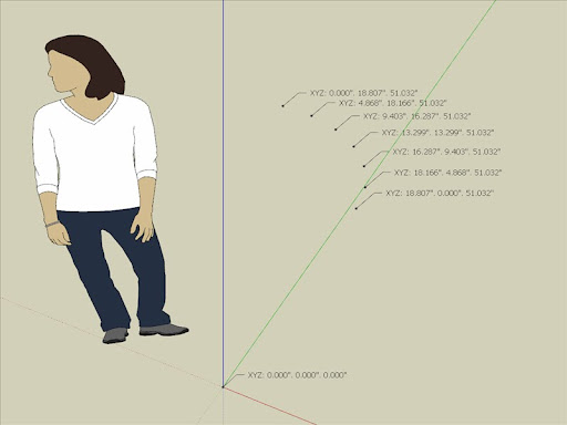
I’m fairly certain there is no problem is with the CSV file as I can import the file with the version of ‘Import Points Cloud’ script I’m running and all 49 points appear as in the image below.
The points in the CSV file describe the vertices of a cylinder with 24 segments (48 points)
The 49th point in the CSV file is at the origin [0,0,0]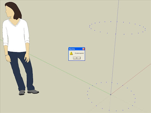
I’ve been methodically trying different combinations of settings in the script settings dialog, to no avail.
Perhaps if we (or is it just me who's fouled up) manage 'Import Coords-Tags from CSV' in simple XYZ length units to work, then we’ll (I'll) be able to figure out the process using XY=LL/Z=Feet.
Many thanks for your efforts, TIG.
-Geo
-
Geo
Can you zip and post your 'problem' CSV file so I can try it - telling me the 'units' [feet?]....
-
Hi TIG,
Here is: Points Test.zip
The units were inches @ 6 dp
-Geo
-
@george said:
Hi TIG,
Here is: Points Test.zip
The units were inches @ 6 dp
-Geo
Thanks, I'll have a look at it - by the way you attach modestly sized zips etc like this direct to your posts...
-
Here's an updated version http://forums.sketchucation.com/viewtopic.php?p=284829#p284829
v1.8 - Typos in Import-CSV fixed to allow -ve values, z=0 & no z.
I had some stupid code errors that meant that xyz values with any negative numbers were skipped and also they were getting skipped if z didn't exist or was 0
Now all fixed...George - your CSV now works perfectly! two 24 point circles one above the other, and one cpoint at the origin - 49 in all...
-
@tig said:
.... by the way you attach modestly sized zips etc like this direct to your posts...
Forgive me, TIG.
We do not have such modern conveniences over at Google SketchUp Help Forum.

-Geo
-
@tig said:
Here's an updated version v1.8 ... Now all fixed...
George - your CSV now works perfectly! two 24 point circles one above the other, and one cpoint at the origin - 49 in all...
Yes !!!The CSV import in LL/Z units works perfectly as well !!!
I'll alert the OP in the GSHF thread ... where all this commotion started.
Thank you, TIG. You are the master

Thanks to Gaieus also.
-Geo
-
Many thanks for this update, TIG!
(and Geo, for being so persistent!)

-
Thanks for the plugin!
When I set XY units to <None> I get following report in the Ruby Console:Error; #<TypeError; nil can't be coerced into Float> C;/Program Files/Google SketchUp 8/Plugins/#coordstexttagtoolfromdatum.rb;291;in `*' C;/Program Files/Google SketchUp 8/Plugins/#coordstexttagtoolfromdatum.rb;291;in `units' C;/Program Files/Google SketchUp 8/Plugins/#coordstexttagtoolfromdatum.rb;493;in `settings' C;/Program Files/Google SketchUp 8/Plugins/#coordstexttagtoolfromdatum.rb;1209 -
Tomasz
Here's v1.9 http://forums.sketchucation.com/viewtopic.php?p=284829#p284829
I think I fixed the typo glitches that messed up the <None> options... -
Is it possible to change at least one point coordinate to the real wgs84 coordinate? And after it all coordinates will be exported relative to this georefareted point??
-
You set a datum and that fixes [0,0,0] as what you've entered ?
I'm unsure I understand you otherwise ??
Hello! It looks like you're interested in this conversation, but you don't have an account yet.
Getting fed up of having to scroll through the same posts each visit? When you register for an account, you'll always come back to exactly where you were before, and choose to be notified of new replies (either via email, or push notification). You'll also be able to save bookmarks and upvote posts to show your appreciation to other community members.
With your input, this post could be even better 💗
Register Login


Advertisement