sketchucation logo sketchucation
    • Login
    1. Home
    2. George
    3. Posts
    ℹ️ Licensed Extensions | FredoBatch, ElevationProfile, FredoSketch, LayOps, MatSim and Pic2Shape will require license from Sept 1st More Info
    Offline
    • Profile
    • Following 0
    • Followers 0
    • Topics 1
    • Posts 30
    • Groups 1

    Posts

    Recent Best Controversial
    • RE: [Plugin] Coords Text Tag from Datum

      Hello TIG,

      I opened 'Test Model 1' and did the following:

      Window > Ruby Console
      Plugins > Coords-Tag > Settings, then Add

      The Settings, then Add dialog was as I last left it.
      Like this:

      http://lh4.ggpht.com/_pI3lDYnW_xk/TTotXAqJJsI/AAAAAAAAD7A/3T8afz4yhSg/ScreenShot106.jpg

      When I click OK to close the Settings, then Add dialog:

      This error appears in the Ruby Console

      http://lh4.ggpht.com/_pI3lDYnW_xk/TTsUhreuDSI/AAAAAAAAD7c/_6GQ7-MThSY/ScreenShot107.jpg

      If I then click … Plugins > Coords-Tag > Add Coords-Tag:

      This error appears in the Ruby Console

      http://lh3.ggpht.com/_pI3lDYnW_xk/TTsZjTxmgLI/AAAAAAAAD7k/oRS36W11RYM/ScreenShot108.jpg

      I close the model without saving changes and then reopen the model.

      Window > Ruby Console
      Plugins > Coords-Tag > Add Coords-Tag by Dialog

      This error appears in the Ruby Console

      http://lh5.ggpht.com/_pI3lDYnW_xk/TTsk-kjTmjI/AAAAAAAAD74/FzhQF98vMfs/ScreenShot109.jpg

      I hope this helps.

      -Geo

      Btw, this all started with a discussion in the SketchUp Help forum.
      http://www.google.com/support/forum/p/sketchup/thread?tid=11ef233d3545c5f0&hl=en

      The ability to create Cpoints directly from L. Lo. coordinates is a most welcome asset. 👍

      Thank you, TIG

      posted in Plugins
      GeorgeG
      George
    • RE: [Plugin] Coords Text Tag from Datum

      Hello TIG,

      Here’s what I’m doing, step by step.

      1. Open a new SU8 Pro file.

      2. Click … Window > Model Info > Geolocation > Set Manual Location

      3. 2x click the cursor in the Latitude field and then type 46.0N

      4. 2x click the cursor in the Longitude field and then type 90.0W

      5. 2x click the cursor in the Location field and then type Northern Wisconsin

      6. Click … OK to close the Set Manual Geo-Location dialog box

      The Model Info-Geo-location panel then appears like this:

      http://lh6.ggpht.com/_pI3lDYnW_xk/TTnrbF4QuOI/AAAAAAAAD6Y/F1R9aRAaUX8/ScreenShot102.jpg

      1. Select and delete Susan

      2. Click … Window > Model Info > Statistics > Purge Unused

      3. Click … Window > Components and place the Simple House component at the *origin.
        *Drawing Axes are confirmed to be in default position.

      4. Click … File > Save, type in the name, Test Model 1, and then click Save
        The Save as Type: field is set to save as the current version, SketchUp Models (*.skp)

      5. In the Model Info-Units panel:
        Length Units are set to decimal inches at 0.000” precision
        Enable Length Snapping is OFF.
        Display Units Format is ON.
        Enable Angle Snapping is ON at 15° and Precision at 0.0°

      6. Click … Plugins > Coords-Tag > Settings, then Add
        The Select tool cursor becomes a white arrow.
        Set XY-Units to Latitude_Longitude
        Set Z-Units to <None> (I tried all the other settings for Z as well, without success.)
        Set Units?: to Yes
        All other settings remain untouched.

      The Coords-Tag Settings dialog now looks like this:

      http://lh4.ggpht.com/_pI3lDYnW_xk/TTotXAqJJsI/AAAAAAAAD7A/3T8afz4yhSg/ScreenShot106.jpg

      1. Click … OK to close the Coords-Tag Settings dialog box
        The cursor returns to being the Select tool.

      2. Click … Plugins > Coords-Tag > Add Coords-Tag by Dialog
        Nothing happens.
        The dialog does not appear.
        The Cursor remains the Select tool.

      3. Click … Plugins > Coords-Tag > Add Coords-Tag
        The cursor becomes a white arrow tool.
        It offers no inferencing dots or tool tips while hovering over the origin or endpoints.
        L-Clicking or R-Clicking on geometry or on the ground plane does nothing.

      All the tools work perfectly if I return to the Coords-Tag Settings dialog box and set XY-Units to ANY other unit besides Latitude_Longitude.

      If I create a few tags with the XY-Units set to Feet or Meters and then return to the Coords-Tag Settings dialog and change XY-Units to Latitude_Longitude, the existing tags convert correctly to L. Lo. coordinates, after which, the tool remains active. I’m then able to inference and a L-click places another LL Tag and another and another.

      With the LL tags thus functioning, I then go to Plugins > Coords-Tag > Add Coords-Tag by Dialog and enter the model coordinates, L 46N Lo 90E
      Like so:

      http://lh3.ggpht.com/_pI3lDYnW_xk/TTnrcAfxaAI/AAAAAAAAD6g/k3EkdvhYVpg/ScreenShot104.jpg

      The LL tag appears at L 0.018N Lo 87.000W
      No matter what I try, it returns the same value every time.

      Sorry this is so long.
      Does my opus give you some clue as to what the problem is?

      Thanks,

      -Geo

      posted in Plugins
      GeorgeG
      George
    • RE: [Plugin] Coords Text Tag from Datum

      Hello TIG,

      I’m working with Coords Text Tag from Datum v1.6 20101120

      Gaieus suggested the plugin as a means of creating guide points at specified locations in a geo-located model using Latitude and Longitude as input data via ‘Add Coord by Dialog’.

      The plugin works as expected with length units ... inches, feet, meters and so on.
      However, entering LL data via ‘Add Coord by Dialog’ yields odd results.

      These are the settings:

      http://lh6.ggpht.com/_pI3lDYnW_xk/TTnrapV6vDI/AAAAAAAAD6U/nSAVx1Q6Ysg/ScreenShot101.jpg

      This is the location of the model:

      http://lh6.ggpht.com/_pI3lDYnW_xk/TTnrbF4QuOI/AAAAAAAAD6Y/F1R9aRAaUX8/ScreenShot102.jpg

      When I click the Add Coords-Tag tool on the Origin, the coord-tag is correct:

      http://lh6.ggpht.com/_pI3lDYnW_xk/TTnrbbjHM5I/AAAAAAAAD6c/A9fvdljRD-M/ScreenShot103.jpg

      Then I try entering the exact model location in ‘Add Coord by Dialog’:

      http://lh3.ggpht.com/_pI3lDYnW_xk/TTnrcAfxaAI/AAAAAAAAD6g/k3EkdvhYVpg/ScreenShot104.jpg

      The result is consistently a coord-tag with Latitude way off to the south, near the Equator:

      http://lh4.ggpht.com/_pI3lDYnW_xk/TTnrcvIo1fI/AAAAAAAAD6k/-FtWZ6F9AtM/ScreenShot105.jpg

      I tried unloading all plugins and the extensions in the Preferences-Extensions panel so this was the only plugin loaded when SU starts.
      The results were the same.

      I'm at a loss to figure out what's wrong.
      Am I entering the data improperly?

      Thanks,

      -Geo

      posted in Plugins
      GeorgeG
      George
    • RE: Get together before base camp

      I’ll be there!
      I’m looking forward to meeting everyone.
      My flight lands in Denver at 10am Tuesday.
      Suppose I'll get to the Boulder Bluff Best Western around noon.
      Despite what they say about people looking like their pets, my nose is not pink … until I've had a few. 😉

      http://lh6.ggpht.com/_pI3lDYnW_xk/THm2pVovGiI/AAAAAAAADXA/qgTuBR7hot8/Me BW Orig.JPG

      Geo

      posted in Corner Bar
      GeorgeG
      George
    • RE: Newbie - Probably a Dumb Question

      Thank you, 🤓 TIG

      Your generosity, dedication and Uber Geekness know no bounds.

      ☀ Geo

      posted in Newbie Forum
      GeorgeG
      George
    • RE: Newbie - Probably a Dumb Question

      Thanks for your help TIG. This Cloud_v6 script has been driving me nuts.

      @tig said:

      Can you link him to here viewtopic.php?p=212737#p212737 - to make sure he's downloaded the 'fixed' cloud_v6.rb first...

      That's already been done ... by another poster, which is how I found this thread. 👍
      BTW, Do you know if Didier added your fix to the RLD download copy of the script?

      @tig said:

      The glitch I fixed seems related to a recent maintenance update that changed the 'order' of the units options that Didier fell foul of - my fix got what's needed in a different way, and thereby avoided that problem - so it should be future-proofed, at least for that particular issue !

      Now I'm confused (more). I'm running XP-Pro SP3 and the latest version of SU Pro 7.1.
      I've worked with this original copy of Cloud_v6 several times in the past with various csv files, including the one posted by 30KView above and it has never failed.

      Why do you think the script (which I downloaded from RLD long ago ... Prior to your posted fix) runs on my XP system yet fails on Vista as related in this thread? Is the script problem/fix OS related ?

      Another thing that is a mystery (to me).
      When I open the Cloud_v6 file.rb I am using, it looks like (technical term) gobbledygook.
      Below are the first four lines I copied from the script as it appears in MS-Notepad.
      I neither read, write nor speak Ruby, but I've opened a few scripts and I've never seen the likes of this. 😲

      eval %q{IyBDb3B5cmlnaHQgRGlkaWVyIEJ1ciAtIDIwMDQKIyBBIHBlcnNvbmFsIGxp
      Y2Vuc2UgaXMgZ3JhbnRlZCB0byB5b3UgdG8gdXNlIHRoaXMgcHJvZ3JhbSBm
      cmVlbHkKIyBZb3UgYXJlIG5vdCBhdXRob3JpemVkIHRvIG1vZGlmeSBvciBj
      b3B5IHRoaXMgc2NyaXB0CiMgdG8gdXNlIGF0IGVuZHMgb2YgdHJhZGUKIyBU
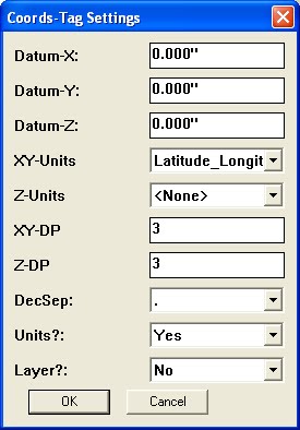
      Is this the script? 😕

      posted in Newbie Forum
      GeorgeG
      George
    • RE: Newbie - Probably a Dumb Question

      Hello TIG,

      Our friend Will, over in the SU Help Forum, is having a similar problem with Cloud_v6.

      I have posted copies of his csv file and a copy of the Cloud_v6 script that works perfectly on my XP system but fails on his Mac OS X 10.5.8.

      As a test, I downloaded the example.zip file in this thread. It works fine with my copy of Cloud_v6 ... The same copy of Cloud_v6 that fails on Will's Mac.

      Your Ruby expertise would be most welcome here: http://www.google.com/support/forum/p/sketchup/thread?tid=7b04ae9067b5834a&hl=en

      Thanks,

      Geo

      posted in Newbie Forum
      GeorgeG
      George
    • RE: Crazy weather...

      Spring weather has come to the Northwoods of Wisconsin 46° N

      Two feet of snow cover has disappeared in the last ten days. There’s very little snow left on the ground.
      I don’t trust that our spring is truly upon us. Winter weather is never over this early here.
      I've been waiting for the other shoe to drop. It appears to have dropped on Dallas. 🤣

      posted in Corner Bar
      GeorgeG
      George
    • RE: Better support for other file formats

      @gaieus said:

      Hi Geo - and though you are not newhere, still nice to see another Sage!
      😉

      Yeah, I thought I'd stop by to see the new board version. Looks good from this end of the wire. 👍

      I’m still pondering how to make more use of Layout.

      Working on a PC, it seems Layout ceases to have much use once I’m past the presentation stage. Aesthetic presentations are an important part of homebuilding. However, the workflow in a Design/Build firm is perpetually towards the final working drawings. Layout would be useful throughout the building cycle if I could use it to bring everything together, from preliminary SU models to final CAD working drawings (importing a PDF copy of Excel and Word documents would be useful too).

      The demand for more detailed formal working drawings is increasing with the complexity of our dwellings and the sudden realization (as if no one knew this before the big crash) that better plans mean better business. This article, in the September ’09 issue of ‘Builder’ — The Magazine of the National Association of Home Builders (US), points out the direction builders, designers (and their tools) need to be headed.

      http://www.builderonline.com/cost-saving-ideas/the-great-cost-chasm.aspx

      -Geo

      posted in LayOut Feature Requests
      GeorgeG
      George
    • RE: Better support for other file formats

      @bjanzen said:

      I hear you, Gai... yes, vector import is best done for now by trying to get a vector format into SketchUp, then importing the model from SketchUp and vector rendering in LayOut.

      b

      Hello bjanzen and Gaieus,

      I just started working with Layout (PC).

      I've been experimenting ... Trying to bring a vector copy of a (complete) DXF floor plan into Layout. The only way I've found so far is to import the DXF into SU and then send it to Layout. As I'm sure you know, this removes all the line types from the drawing, rendering it useless for practical use in the field. I regularly use Adobe Acrobat Standard v9.3.1 for creating PDFs of our CAD construction documents. However, it appears there's no way to import a PDF into Layout on a PC.

      I would desperately like to combine an assortment of key SU model views with our formal working drawings in Layout. How do I get there?

      -Geo

      posted in LayOut Feature Requests
      GeorgeG
      George
    • 1
    • 2
    • 2 / 2