I have been one of the complaining pissed off users. I've demoed several of the Autocad and Revit add-ons but the workflow just didn't suit me and why should I pay almost $300 for something I used to be able to do. But it gave me some insight into how they work and apparently the Google Earth api isn't as restrictive as Google Maps because this is what these add-ons are using (or they're just breaking the terms?). Anyway Dave R in another post asked what the alternative is? Well that's not my job but the folks at Trimble who have been taking my money for the last 5 years and had plenty of time to come up with a better alternative. Trimble should be ashamed to offer this crap as a "pro" feature. With that being said, here is my alternative, the whole process takes me about a 1/2 hr. And sometimes I have to do some cleanup, in the video I removed about 20 points from the surface to get rid of the "bumps" in the road and any super sharp elevation changes. I've used this process on several sites now and am pretty satisfied, I get a surface identical to Google Earth with high res terrain and imagery. And as a bonus I get a terrain skirt for section cuts. I've also had a very quick communication with Daniel Tal to see if this process or something similar can be integrated with and automated by Placemaker.
Posts
-
RE: Implications of end of google earth
-
RE: Geolocation 3D toggle feature removed
That's my whole problem with this Dave, if it's against Googles terms of service how are all these 3rd party apps doing it? Besides Cad to Earth, there are quite a few others, like these two.
-
RE: Geolocation 3D toggle feature removed
Dave, I know you keep telling me it's Google, but why?, what's the whole story? I don't understand how all these other cad products can have access to Google but not Trimble. As a alternative, I don't know, but this was a feature I used almost daily from survey recon, land development massing, to UAV flight planning and of course for presentations and renders in conjunction with Skatter. I have downloaded the Cad to Earth demo mentioned above and will be trying whatever else I can find and when I find one with a workflow I can live with that's who will be getting my money, not Trimble. Trimble must of known this was coming, could of guessed that this would piss off a lot of users and should of been working on a decent replacement from day one. I have been pretty happy with what Trimble has been doing with Sketchup till now as it really degrades my everyday use of Sketchup.
Mike
-
RE: Geolocation 3D toggle feature removed
Yeah this is total crap, my Sketchup maintenance fee this year will not be going to Trimble but towards whichever 3rd party gets me back decent terrain and image resolution.
Mike
-
RE: Implications of end of google earth
Yes I can get better images and terrain data like lidar or dem but how do I get that into Sketchup? Without 10 different work arounds. Might as well go back to Autodesk. And I still feel I have the right to be frustrated with Trimble no matter what Google did, after all it's been Trimble that I have given my money to for the last 5 years and in return I'm getting an inferior replacement for what I consider an important aspect of the software.
-
RE: Implications of end of google earth
@unknownuser said:
As I user, I could care less if they use drones or oil tankers...I just need high quality data...and DG is NOT!
Totally agree, not only is it not as high of a resolution it's old, working on a site now that has a fairly new building on it which I can see on Google maps but not on the DG imagery.
@unknownuser said:
You should be frustrated with Google. It's they who are removing the option to use their imagery.
I think it's fair to be frustrated with Trimble, I'm losing a feature that I consider valuable and that I paid for and it's being replaced by an inferior product, will my SU license cost less ? I don't understand why Trimble couldn't work out a deal with Google and pay for their map data like a lot of apps do. Or even Bing maps like Autodesk did. DG to me is pretty useless.
-
RE: Does a plugin like this exist ?
Thanks everyone, got it sorted with split tools. Where it didn't work was user error by picking the wrong edge.
-
RE: Does a plugin like this exist ?
Yes pilou that would work when I was modeling however the model is complete and I just need to add the edges to do a proper uv map in Blender.
-
RE: Does a plugin like this exist ?
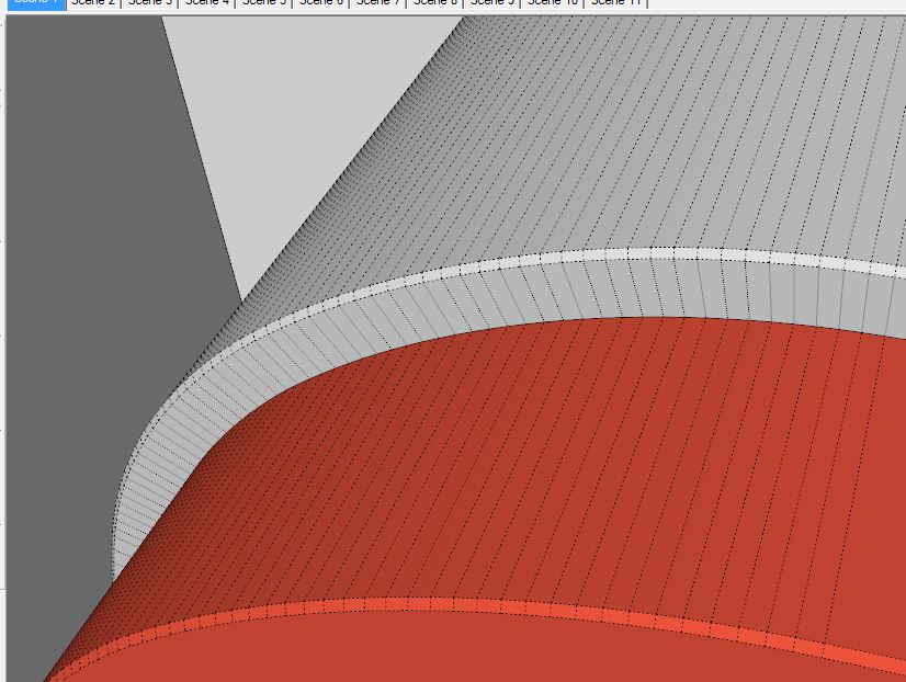
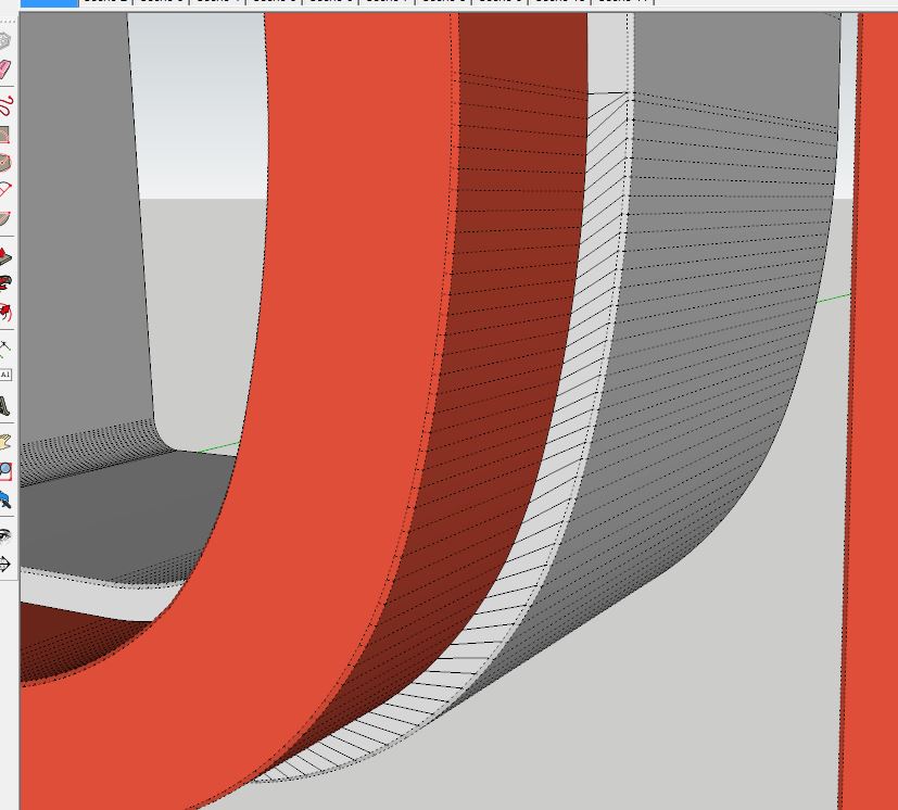
Yes I've tried split tools but really don't know what it expects as to the geometry, tried manually dividing the surface several different ways to give split tools what it wants without any luck. On some of the curves it works perfect as in pic one but sometimes it seems to offset the split by one line like in pic 2, any advice ? Is it because the first curve segment is smaller than the rest ?
-
Does a plugin like this exist ?
So I created a drawing with a ton of curves in it, the project has progressed to where now I'm uv wrapping it in Blender which wasn't planned on from the start or I would have modeled it differently. I need to have quads. First pic shows what I have now, second picture is what I want. I can do it manually but would be very tedious as I said I have lots of these curves with lots of segments. Is there a plugin that will do this or some other workflow that's quicker than drawing each line ?, thanks in advance.

-
RE: A few thoughts about the future of this planet
@mike lucey said:
In the so called 'Western World', Direct Democracy is quite workable now that we have this high level of telecommunication all around us. Ordinary citizens are more than capable of making informed and sensible judgement votes over their mobile phone on a daily basis if needed.
Depends on where these ordinary citizens get that information and if they're willing to research what they read and not take it as gospel. Fake news was a big problem with this election not only on Facebook but all over the internet. I think this set a new precedent for future elections where there will be information overload and be harder to distinguish fact from fiction, very effective.
-
RE: Developer needed to maintain Visualizer for Sketchup !!
Trimble may already be working on some kind of render for Sketchup.
-
RE: Can't wait for this extension
Haha, guess that's what happens when I don't visit every day. Awesome plugin though.
-
RE: Plugin request for 3D Laser "Leica Disto S910 "
mjaskiewicz, can you explain how point gadget works with online data stream, I've used it for some small survey jobs by just importing a csv file, are you saying with point gadget I can connect to say a total station and capture measurements in Sketchup? Thanks for any info.
Mike
-
RE: [Plugin][$] Vertex Tools
No issues downloading through the extension warehouse
-
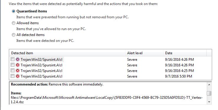
RE: [Plugin][$] Vertex Tools
thomthom, Windows 7 Professional and Microsoft Security Essentials, if it makes a difference.
-
RE: [Plugin][$] Vertex Tools
thomthom, I was trying to update my version of vertex tools by downloading the latest version from your site and it keeps getting flagged as a virus.
Mike
-
RE: 3d Trimble scanner/camera
Here's their hand held unit, http://www.trimble.com/construction/DPI-8-Handheld-Scanner
No experience with it. Then there is also their full size 3D scanners. Both create point clouds not images, but with the full size scanner, once it's done scanning, you can remove it from the tripod and using an adapter mount a camera and take pictures to cover almost 360°. This will give you images and can be used to colorize the point cloud also, though all in Trimble software of course. -
RE: Render SU Section
I'm pretty sure that Thea does also.