sketchucation logo sketchucation
    • Login
    1. Home
    2. sketchymick
    3. Posts
    ℹ️ Licensed Extensions | FredoBatch, ElevationProfile, FredoSketch, LayOps, MatSim and Pic2Shape will require license from Sept 1st More Info
    S
    Offline
    • Profile
    • Following 0
    • Followers 0
    • Topics 15
    • Posts 113
    • Groups 1

    Posts

    Recent Best Controversial
    • More on contours and topography

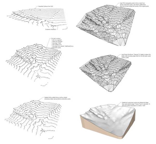
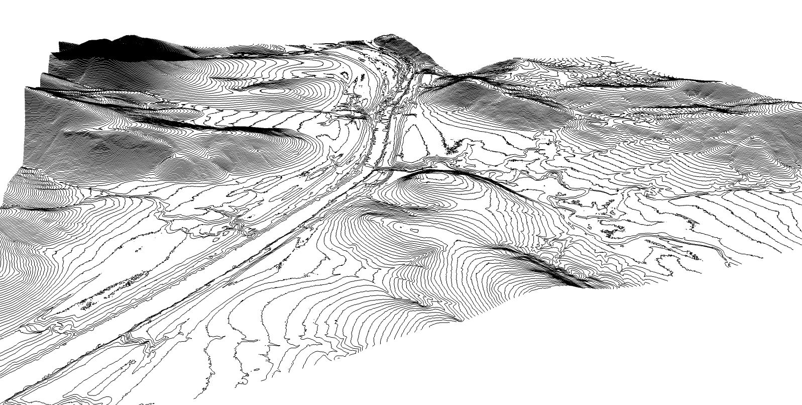
      Hi everyone. Some of you may have read a previous thread of mine http://forums.sketchucation.com/viewtopic.php?f=79&t=42645 where I wish to create a large accurate topographic surface from contour lines imported from CAD. I'd tried all the suggestions in that thread and it was a great learning experience, however I didn't quite get to my ultimate solution there.

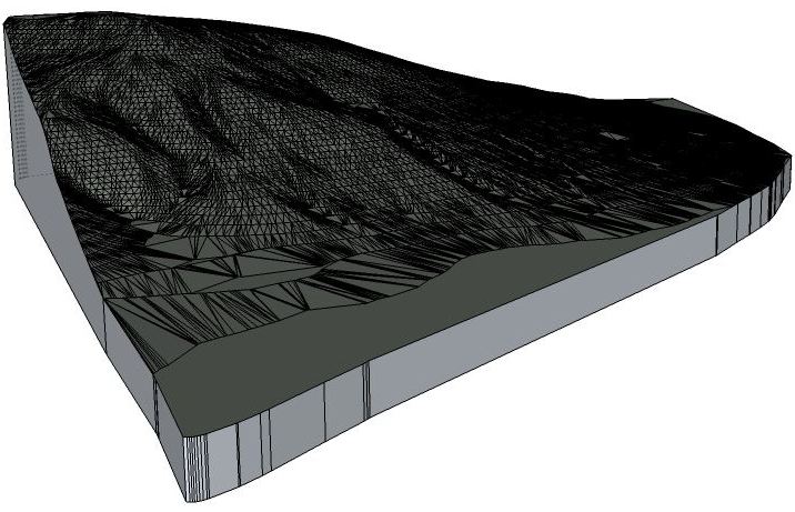
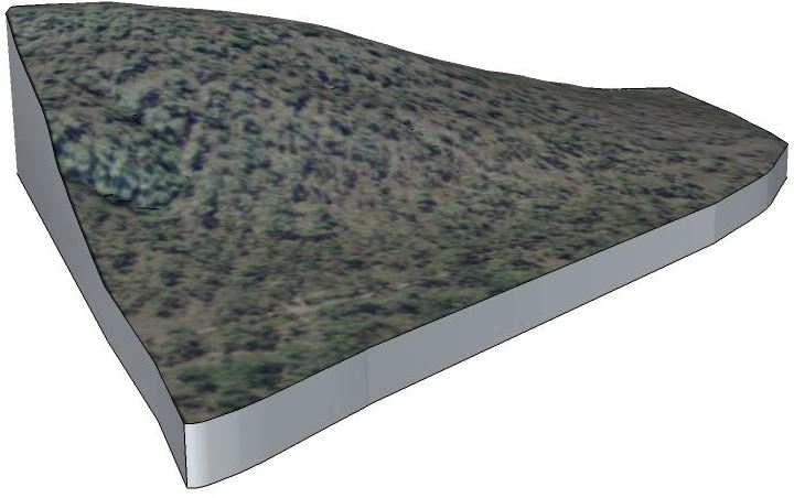
      I now have a workflow that creates what I require, but it is labour intensive and slow. I've posted the attached sketchup file, not only as a plea for more help, but I also hope this may be of assistance to others working with CAD contours. This is just a small section of the model that I actually want to produce. I've saved my workflow as series of scenes - I'd really appreciate it if you folks could scan through it and see if there is a way to improve this. In particular - in scene 2 you'll see that I select a contour segment, expand the selection to 'all connected', weld this to a single curve before adding equally spaced guide points along the curve. At the moment I have to do this for each contour individually.

      It's also worth noting that I've tried thomthoms edge tools>simplify, but with my data this still yielded contours that either crossed over too much using a wide tolerance or were too complex to efficiently create a surface from when using a tighter tolerance.

      thanks in advance

      • Mick

      topography from CAD contours.skp


      scenes.jpg

      posted in Newbie Forum sketchup
      S
      sketchymick
    • RE: Merging topography and creating solids

      Jean - thankyou that's a nice way to go about it.

      Zapwizard - that's a good suggestion using TIG's drape control points plug in - I'll experiment a bit with this. I had a very quick look at Artisan, but need to research it a bit more... but from what I can see, it is possible to manually add or simply detail in the mesh. It would be good however if there was a tool that could analyse the vertical complexity in the xyz data so that points that were similar to their neighbours would be tagged as redundant, so that an optimal irregular mesh could developed. Does such a plug in exist? Does Artisan do this?

      Thanks for your replies so far

      • Mick
      posted in Newbie Forum
      S
      sketchymick
    • Merging topography and creating solids

      contours.jpgmesh.jpgtrees.jpg

      Hi,

      I have a large landscape that I want to create a detailed solid model of in SU Pro 8. The attached 'contours' pic shows the extent. To tell the truth, this has been on the back burner for a while and I can't remember all the steps I've taken to date, but basically what I have is several overly complex surfaces (different chunks of the ground topography - 1 of the chunks is shown in the 2nd and 3rd pics) which I want to merge together to create a single land surface, then I want to add a skirt and make the whole thing into a solid where I can cut/fill, etc. The data originally came from GIS not google earth (which didn't have enough detail for this application).

      I couldn't work out a way to 'weld' the various chunks of land surface together into one overall surface.
      I've tried cleanup3 to get rid of some of the spare geometry, but what I need is some sort of tool to optimise the surface complexity as well.
      I've also tried add skirt from terrain tools, but couldn't work out a way to merge the terrain surface with the skirt surface to make a solid.

      The file is too large to post (about 50Mb), but I hope the attached gives some idea of what I'm working with.

      Any suggestions greatly appreciated

      thanks

      • Mick
      posted in Newbie Forum sketchup
      S
      sketchymick
    • RE: Sun angle and shadows

      @sketchymick said:

      I'm pretty confident that you'll be spot on with this, and I'm expecting that there will be 11.7 degrees between the north/south shadow and my compass north. One thing I can say is that my prediction is probably more accurate than my ability to measure it. πŸ˜‰

      Well I measured it today and I got about 12.5 degrees - which is good enough for me given the error is about as much as the thickness of the graduations on my compass. So Jim, I reckon your method works a treat. πŸ‘

      posted in Newbie Forum
      S
      sketchymick
    • RE: Sun angle and shadows

      @jim4366 said:

      No expert, but I was wondering if you could use the sun itself to get your north angle.Taking some numbers:

      longitude 153 degrees east -just guessing
      lattitude 29 degrees south
      time zone -10 hours east of Greenwich,
      but if you're on daylight saving time,
      11 hours east of Greenwich

      Plugging them into the link provided by George (http://aa.usno.navy.mil/cgi-bin/aa_pap.pl) you get:

          Begin civil twilight      05:31                 
          Sunrise                   05:58                 
          Sun transit               12:55                 
          Sunset                    19:51                 
          End civil twilight        20:18 
      

      Regarding sun transit. I'm pretty sure this is solar noon, or "high noon". When the sun is highest in the sky and due north/south. So I'm pretty sure for you, today, this will happen at 12:55 p.m.
      So if you were to pound a stick in the ground, it should cast a shadow exactly north/south. I think.
      If it helps...

      G'day Jim,

      I like your thinking... in fact I did the sketchup version of this last night before seeing your post... and noted that the time in SU when I got the shortest shadow was indeed 12:55. I also noted that the angle of the shadow from vertical at the summer solstice was roughly 5.4 degrees in SU, which equated pretty well with my latitude (i.e. 23.5 +5.4)

      I won't be around over the next few days, so won't be able to try out your suggestion for a few days, but will do so at some stage. I'm pretty confident that you'll be spot on with this, and I'm expecting that there will be 11.7 degrees between the north/south shadow and my compass north. One thing I can say is that my prediction is probably more accurate than my ability to measure it. πŸ˜‰

      Great suggestion.

      I was also playing around with a few different sun position plugins just for interest, which I would recommend to anyone trying to visualize the behavior of shadows in their part of the world.

      Cheers

      • Mick
      posted in Newbie Forum
      S
      sketchymick
    • RE: Sun angle and shadows

      @wo3dan said:

      @sketchymick said:

      ...... it means that I do need to use my compass:

      • determine orientation relative to magnetic (compass) north
        - make a correction for local magnetic deviation (in my case add 11.8 degrees to my compass reading)- then I can enter my north angle.......

      Right, and since this changes over time (can also be found for instance on nautical maps, year_related) you can see that shadows cannot simply be "connected" to magnetic north. Too difficult and to much data in the background while not even relevant for shadows. The compass is and local information is the way to go in your case without good satelite information.

      11.8 degrees is a lot. Do you live in Canada?

      p.s. Mick and irwanwr, credits go to George Knowles.

      No I'm in eastern Australia latitude 28.8 south. A topographic map of the area shows that there is a 0.3 degree variance between Grid (map) and True north. Then there is an additional 11.8 degrees between TN and Magnetic North. That figure is for 2002, but magnetic variation is stated as being only -0.01 degrees per year.

      Just by coincidence, some walls in the house are aligned perfectly with magnetic north at the moment...

      Regards

      • Mick
      posted in Newbie Forum
      S
      sketchymick
    • RE: Newbie trying to understand shadowing and camera view

      Have a look at my recent thread on sun angle and shadows. Wo3Dan provided a link there which explains the whole process which I found useful. Your problem might have something to do with shadows being shown on the ground plane (not the topographic surface?). Go to shadow settings: "On Ground". Cheers - Mick

      posted in Newbie Forum
      S
      sketchymick
    • RE: Sun angle and shadows

      @wo3dan said:

      Are you 100% sure you started with a "clean sheet", no manipulated axes?
      It's hard to tell what went wrong. But resetting the axes and (as you found out) rotating the house back according to fit geolocated image of the house, should do it. Remember that for agood shadows your model needs to be geolocated. orientated correctly and you need to slide to the right day and time.
      There's not much else that you can/need to do.
      Reproducing your (if any) mistake isn't easy without the steps you made.
      See this tutorial by George Knowles about "real world shadows":
      https://docs.google.com/View?id=dd3gmtxm_767g4m4j7ns

      Wo3Dan, thanks. Yes, I started with clean sheet, etc but I just couldn't get my head around the fact that there was no way that sketchup could know the orientation of my model without me providing the data. The link you provided cleared it up for me. Firstly it confirmed that "North" or "Solar North" is actually "True North" (not Grid North or Magnetic North). Given that I do not exactly know the orientation of any of my walls in relation to true north, it means that I do need to use my compass:

      • determine orientation relative to magnetic (compass) north
      • make a correction for local magnetic deviation (in my case add 11.8 degrees to my compass reading)
      • then I can enter my north angle.

      As it turns out I was only 2 degrees out, but anyone who's played with shadows will realise this can be significant

      Thanks for you help
      Regards

      • Mick
      posted in Newbie Forum
      S
      sketchymick
    • RE: Sun angle and shadows

      @wo3dan said:

      Mick, forget about magnetic north. That's not relevant for shadows.

      You may have to reset your drawing axes to return to the systems axes. Right click on an axis and see if reset is available.
      For if you enter an angle for north it would be an angle towards systems green axis. Not (probably your case) towards a rotated green axis.

      OK thanks - I reset the axes, and yes the north arrow now deviates by the 0.23 degrees now, so that makes sense.

      But I don't think I've got a grasp on my original question... if you refer to the sketch, it shows none of the walls are aligned with any of the cardinal points. When I drew the house, I just used the default axes. Then when I set the geolocation, the house was not orientated anywhere near correctly... so I rotated it around the blue axis to align roughly by eye with reference to the google earth image - however,the base image is so fuzzy that I could easily be out by 10 degrees as it is hard to get a sharp edge to align to. How can I be exact?

      thanks

      • Mick
      posted in Newbie Forum
      S
      sketchymick
    • RE: Sun angle and shadows

      @tig said:

      You can set North using the Preferences Extension provided with Pro = 'Solar North Toolbar'.
      This means you can leave your model with sensible XY axes for the main walls for easy modeling etc, but tell it to use a North direction you have set for the Sun etc - it will usually be somewhere 'near to' the Y-axis - otherwise the North is usually taken to be the Y-axis [green], give or take as the geo-location does sometimes seem to give slightly 'off' axis results.

      thanks for your reply TIG... I had actually explored that option, but I couldn't find any reference to whether "Solar North" was the same as magnetic north or if there was some correction required. The north direction is roughly right but how do I know exactly?

      I note that my current north angle is 0.23 degrees if I go to enter a north angle, whereas the north arrow shows that it is about 30 degrees east of the red axis (see pic attached)

      I'm afraid I just don't understand it all

      thanks

      • Mick

      house.jpg

      posted in Newbie Forum
      S
      sketchymick
    • Sun angle and shadows

      Hi,

      I'm using SU 8 Pro and have a house model that I want to get the shadows right on. It's close but not perfect.
      I've set my geolocation, but unfortunately the available aerial imagery isn't crisp enough to allow me to match the orientation of the model against the photo.

      I have a compass, so can get the magnetic orientation of a wall, but I'm not sure how this equates to sun angle.

      Could someone please suggest a method? I'm in eastern Australia

      Thanks in advance

      • Mick
      posted in Newbie Forum sketchup
      S
      sketchymick
    • RE: [Plugin] Coords Text Tag from Datum

      thanks for the reply TIG, I missed the <none> option before. I've also tried out the Add height from datum tool, so now have all based covered.

      thanks again

      • Mick
      posted in Plugins
      S
      sketchymick
    • RE: [Plugin] Coords Text Tag from Datum

      Dear TIG - fantastic plugin - thank you.

      I was wondering if there was a way to customise what the label actually displays. In my application I would like to tag certain points with the elevation only. Even better if the label format could be customised - e.g. "RL 10.454 m".

      Regards

      • Mick
      posted in Plugins
      S
      sketchymick
    • 1 / 1