Done. In this community CraigD is a model citizen.
ehaflett
Done. In this community CraigD is a model citizen.
ehaflett
I guess this is now my second second home, eh? Thanks for the upgrade fellas.
No problemo Howard, I share your excitement
I haven't worked with attributes and SU data at all really. My point data attributes are mostly for organization purposes, to make it easier to match the symbol with the model file (see the work flow for more detailed description). Since the models come in as symbols they don't really hold any spatial data really, just a location that is the point layer. The matching of the point attribute in the GIS with the model/symbol name is a manual process.
I'm not familiar with any reader/plugin/extension for ArcView 3.x and doubt you'll find one. If you're looking for a way to view your ArcView shapefiles or GIS data along with your SU data you may find ArcGIS Explorer (AGX) helpful. I'm not sure what your needs are but it's worth a look. It's similar to Google Earth but you can load GIS data, most ESRI formats (includes ESRI's imagery which is quality stuff and pretty recent). I tried loading a Multipatch database into AGX since that's what SU is able to export but no luck. You might try using .kml. Here's a link to AGX
Speaking of the multipatch, that's what I need to look at next. The project I posted above started before the Arc 9.x and SU 6 version plugin came out so I was pretty much married to the method I used. I'll have to go through the workflow posted with the ArcGIS plugin on the SU website and see how it works. I know that if there's any possibility to do what you're asking regarding maintaining attribute data back and forth, it will be there. The workflow I've been following doesn't even attempt to do this. My attributes refer to entire models/seperate SU files and are strictly to help me match them up. The SU files are named after the point attribute which they are to symbolize. I haven't sent any data back to SU from ArcGIS. A bit of circular talking here, sorry. My workflow is simply a way to use SU to create 3D symbols to be used in ArcWhatever. I'm curious why do you want to maintain this relationship? Is your final product to be in ArcView or SU?
I'll certainly post once I get through the workflow. The quick tests I did here look promising. I took an existing model, selected 3 groups of buildings, gave them names in the Entity Info window, then exported them to a multipatch database. The resulting table in the database held the names I gave each group. I'm assuming that if you grouped each surface of a building, gave it an attribute and exported it you'd have what you're looking for. I guess I should read more about the plugin before going further here.
Too bad there aren't more of us here to beat this thing up a little harder. I'm starting another similar project next week, hopefully I'll get to try this out. If you can think of other test scenarios I could run with my software that would help you out let me know.
GEOGRAPHY LIVES!
Ok, guys, a couple quickies...
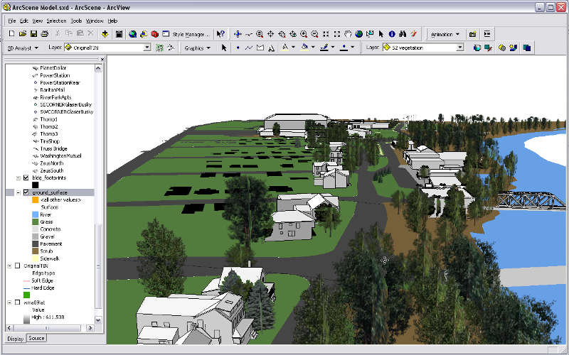
First one is from ArcScene, this is where I bring in the models as symbols. In ArcGIS I digitized 8 different ground cover type polygons and draped it over my elevation data, then draped the building centroid point data on the elevation data. This is where I have to resize and rotate each model (symbol) to fit it's footprint which are the black polygons. Still a WIP.

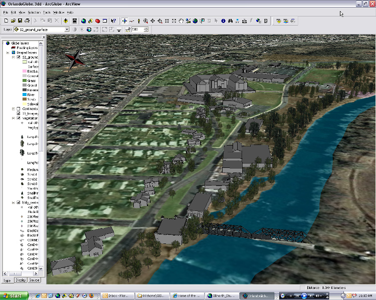
Once the building centroids point layer is symbolized with each model I export it to a layer file and load it into ArcGlobe, that's the second attachment, slightly higher vantage point.

As you can see, one of the issues I'm having is that the buildings each need to be rotated individually in ArcGlobe, the bridge in the foreground being the most obvious example.
The trees are similar to the houses in that they are a point shapefile with different attributes for tree type and size, digitized from aerial and ground photography.
Being the resident expert on this here (that's right, being the ONLY one makes me the expert) here's what I've come up with.
I've done a couple projects where I've been asked to model short stretches of streets and all the adjacent structures, one entirely in SU and one using the SU/ArcGIS workflow referenced in the threads in your post. It's still a learning process for me and I'm still deciding which I prefer. Some questions to ask yourself to help you choose:
-How do you plan on presenting the model? We have been showing it live to small groups of people so it's nice to have it in an environment where it can be manipulated (orbit/pan/zoom) for them based on their feedback as well as turning different things on and off to show different proposed scenarios. I've used ArcScene to build the model and ArcScene and ArcGlobe to present it. I've not been asked yet to produce printed materials but will be soon and realize that ArcGlobe/Scene are limited in their ability to output graphic content. ArcGlobe is nice because it makes using aerial imagery as your ground surface easy.
-What data are you using? If most of your data is GIS data and all you're using SU for is the structures then I recommend staying with ArcGIS because that's what it's meant to do. Also, I'm just more familiar/comfortable with it. The exporter from ArcGIS works great but could quickly complicate a model if too many layers are put into it (creates a new SU layer for each GIS data layer). I also think that keeping the data in the GIS lends credibility to the spatial accuracy of your model since SU isn't proven in this capacity yet (see SU Snobbery thread). I WILL say that when I've been bringing my SU models into ArcGIS as symbols I've had mixed results with them being displayed at the right scale. I built all the structures in SU to scale using a combination of measurements in my GIS of bldg. footprints, measurements taken on site, and photomatch with me standing in front of the structure for height reference. After bringing them in as symbols many of them needed to be resized to fit the dimensions of the building footprints. I haven't quite figured out why this is but I have figured out how to manipulate them in the GIS to make them look right (possible counterpoint to my credibility statement above).
-Why are you building the model? Our main purpose was to understand local scale of structures since we have conflicting land uses in close proximity (I'll not digress into planner-speak). Detail of the model was not as important so the structures are simplified and don't have textures in order to keep files size down. If you need a high degree of detail/realism I suggest sticking to SU since it is good with detail. One of the challenges I ran into early on is the use of terrain. I have a high resolution terrain model in my GIS but when I exported it as a TIN into SU it became unwieldy and difficult to work with due to the high poly count. If you're good at manipulating terrain then go for it, I just haven't had the time to crack that nut yet.
My overall impression is that if my SU skills were better I'd use it for all my models. I'd use ArcGIS for precision X and Y data (what it's best at) and SU for everything else. The terrain issue has been my biggest barrier (glad I wrote all this, I had no idea!).
So, to answer your question, I think the process works well enough to use depending on your needs. It has fit my needs so far but I'm still refining the process.
I hope this is helpful, please post more here if you have more specific questions about my process or anything else. I'm excited to see some interest in this and hope to hear how things go.
If anyone is interested in seeing what I've done just ask, I'll post some screeenshots when I get some time.
I'm using the workflow posted on the SU site to bring my SU models into ArcScene as point symbols. I've already done about 20 or so with little trouble but this one is showing me something new.
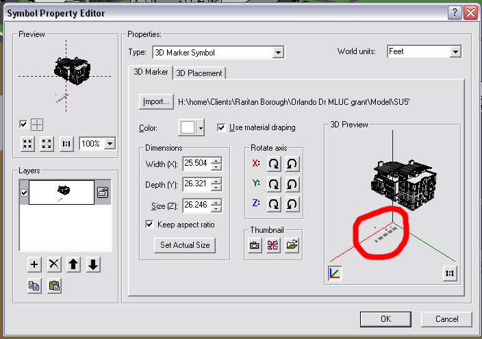
Usually when I bring in a model it will show a preview (attachment) with the model sitting right on the axes. As you can see this model (which I got from the 3D Warehouse) has something in it below the building that shows up on the axes and causes the building to hover above it, which also causes it to do the same when placed in my ArcScene model. However when I open the model in SU it is on the axes as expected and I can't find the elements below it that show up in ArcScene. I've tried selecting all, I've made sure all layers are turned on, and have tried viewing hidden geometry.
Here's a link to the troublesome model in the warehouse:
I've been able to 'beat to fit and paint to match' to make it look presentable but would still like to figure this out since I use this method often. Can anyone help a brother out?
Thx.
------EDIT------
PROBLEM SOLVED
I had to remove all the materials in the model to make it look similar to the others in my model and the mystery elements disappeared. I don't have time to dig into this further to find out which material it was and why it didn't appear, just wanted to post the update.

I thought I'd share this project as a good example of how to use SU and ESRI's ArcScene to model a city. It describes in detail the data layers required, how to set up ArcScene and how to model your buildings in SU for use in ArcScene.
The Project Website:
http://humanitiesgis.org/projects/virtualmotown/index.html
Direct link to the work flow .pdf:
http://humanitiesgis.org/projects/virtualmotown/workflow.pdf
It has been pretty helpful to me so far, I'll post some images here when I've got something worth posting.
Report this post
Coen, thanks for including this forum here. In the old forum it was very useful in getting feedback from the @Last folks about the ArcGIS plugin and bugs, hopefully some/most of that info will find it's way here.
That said, anyone heard any update on this? I know some of us are pretty anxious to get our hands on the version for Arc 9.2 and SU6.
-Eric
Thanks fellas, I'll keep posting what I can.
Hey, thanks for noticing. I thought I was the only one that ever read this forum!
This is something us GIS users have been anxious to see.
If anyone is interested...
I just had something interesting happen, I was placing a building using the 'Get Current View' button and had both GE and ArcGIS Explorer (AGX, ESRI's answer to GE) open, both to the same extent. When the image came in it was a combination of the 2 images, the GE image was bigger but on the bottom (since the extent was slightly larger at the time) and the AGX image was on top. I know it was both because the 2 apps have different imagery loaded (AGX image is newer and shows the building I'm working on, GE doesn't) I've tried to reproduce this a few different ways without success so I can't prove this happened.
My question is has anyone had similar results? Anyone know anything about using it with SU? I'm just now getting my hands on it but would like to know if it offers any additonal/different functionality than GE. Looks like, at least where I'm working, the imagery is newer. I know there aren't many GIS users out here (I'm the only one posting so far) but thought I'd throw it out there.
Thx.