Add Location issues
-
The add location feature was chance in May 22nd 2017, because of the agreement between google and Trimble. (https://help.sketchup.com/en/geodatachange)
Now, that feature import a poor texture and low-poly geometry of terrain.
The only way I found to get around the problem was by using Autodesk Civil 3D 2011 and an older version of Google Earth. Which basically works, like Su 2007.
Civil 3D imports the image and topography, of the area that is displayed in Google Earth.I think everyone would be very happy if there was a plugin with this function.
-
Maybe there is already?
-
Hi. Thanks for the help.
This plugin uses the same database as the current SketchUp system, the "DigitalGlobe". It does not have as much precision as the old system, which used data from Google Earth. It's a good alternative, but it still does not work as well as the old system. -
Are you using SketchUp Make as your profile indicates?
-
@rodolfost said:
Hi. Thanks for the help.
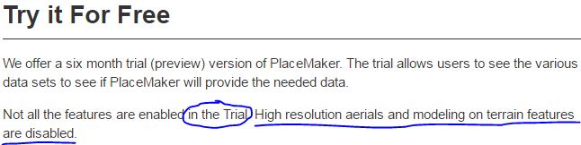
This plugin uses the same database as the current SketchUp system, the "DigitalGlobe". It does not have as much precision as the old system, which used data from Google Earth. It's a good alternative, but it still does not work as well as the old system.Yes, they use the same provider but not the same 'quality level' as they claim. Also note that in the trial, high-res aerials imagery is not available.
Hello! It looks like you're interested in this conversation, but you don't have an account yet.
Getting fed up of having to scroll through the same posts each visit? When you register for an account, you'll always come back to exactly where you were before, and choose to be notified of new replies (either via email, or push notification). You'll also be able to save bookmarks and upvote posts to show your appreciation to other community members.
With your input, this post could be even better 💗
Register Login


Advertisement