Faces appearing from nowhere while working with .dwg import
-
Refreshed the document, 9kb!
I don't think there is a terrain file in there, if there is I can't find it.
Rather than start a new topic and clog for forum. Once I've components drawn, what is the best way of rendering them so they don't look like 90's video games?
-
OK, I seem to have been lost. Back to your original post you mention some "ghost layers". There are two layers there to which some (seemingly?) useless, faraway and stray geometry belongs (marked circled). You can delete those layers if you do not need that geometry safely and choose to "delete content" (I checked that no other geometry is on those layers).
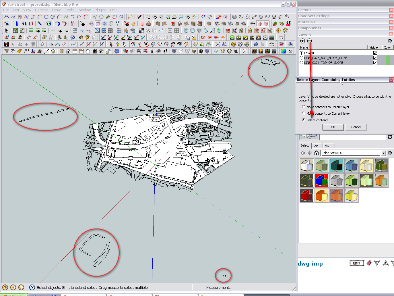
-
Yeah they are indeed "ghost" items. I'll clear them away now.
Should I include my CAD plan to see if the spot heights are tagged to a terrain layer or not, if not is there a way to access them and draw topography from it through sketch up?Sorry to ask such newb questions.

-
I am getting confused now. So there's another file with a terrain?
-
Me too, sorry.
There's two files, the original .dwg and the .skp which is an import of the .dwg. In the original file there's a spot height array which I assumed would build into terrain when I imported it into sketch up ie, going from 2d to 3d so that when I start to lay out the terrain isn't flat but as set out by the spot heights. -
IF you have a set of spot-height points in a DWG... then there are several tools to convert these into a terrain mesh - once they have been imported into a SKP; but they don't magically convert when imported - you do need to do some work...
Also here's a lot of dross in a DWG that you don't need to import into the SKP, that can be deleted/purged first...
If you explained better what you have and what you want to end up with then we could perhaps help you better...

-
I see.
Well, I'm a landscape architecture student and I was planning on presenting my site design using sketchup or at least using it as point where I could try and turn it into some "proper" renders, add illumination get some proper textures in there, make it look less video game like etc.
I was also thinking I could export it through layout to avoid having to redraw things in CAD because I don't know how to use cad properly.
I've ordered a copy of this: http://www.amazon.co.uk/Google-SketchUp-Site-Design-Architecture/dp/047034525X/ref=lh_ni_t_miBut it's taking forever and a day to arrive so I've been trying to do what I can here and there so I'm not dead in the water as the deadlines creep up.
-
All right but what we are trying to squeeze out of you is what you have in hand. Without knowing the kind of the data, we keep stabbing in the dark.
-
Gareth
As Gai pointed out the SKP you gave us only contains a 2d site plan imported from a CAD drawing.
There is no 3d info or 'spot-heights' etc in it...
Can you provide the original DWG/DXF file [r2004 or earlier]?
How do you hope to make this into 3d mesh?
What other information do you have? [that you are keeping to yourself and thereby stopping us helping you to solve this!]If your CAD drawing contains 'text' as spot heights without 'points' then the import will not include them as 'text' is ignored. Also if the text is 'flat' you need to relocate it in the Z with a point so that an import into a SKP then includes it [cpoint-clouds can then be made into a mesh using one of several tools]. I have an AutoLisp routine that does this relocation on a DWG [it's not 'for public consumption', but I can probably help you out]...
However, we need to know what we have to work with here - the longer you keep us in the dark, the nearer the deadline comes; without a solution being at hand... -
Ahhh I see. I'll include my working rough master plan then. I was planning on creating the mesh as I had in the past by working out the lowest point in the model then treating this as the base then drawing an array of verticals where the spot heights on my plan were and then joining them up to create a terrain. I was always certain there was a better way though because it takes forever.
My .DWG came from Leeds city council originally and when the text is turned on has spot heights for the area.
stylistically his is my end goal: http://bp1.blogger.com/_Ymx9e66vrGc/SH7SNrCTvGI/AAAAAAAADco/aFMdUZyfWn0/s400/PT_Eastside_city_view_ready.jpg
http://www.cityfarmer.info/wp-content/uploads/2011/10/harlemfarm.jpg
http://archiculturefilm.com/director/wp-content/uploads/2009/04/biotopes_1000.jpgI was then planning on using layout to produce a master plan that could be overlayed on G.earth to look like this.http://t1.gstatic.com/images?q=tbn:ANd9GcSApdJacS6xlacAc0D-64DMgANB8WCgtiD5iLd2JHm_0ZWUx4bk17pT3hPXAQ
-
First off, this is made with a more recent version of AutoCAD than I have.
I can't convert it using the free AutoDesk converter as it says the DWG has an 'Educational Use Only' stamp in it!
Can you save_as it to a r2004 version and reattach, or PM it...
This is 2d plan it can't be used to make a 3d mesh without running several processes on its data...
I do have tools to find its text entities, read their real heights and relocate them in the Z with points; for import into a SKP, where Ruby scripts can take these cpoints and convert them into a surface mesh.You seem to be making heavy weather of solving this...

-
sorry.
 I'm a forum mod myself I know how frustrating it can be dealing with an idiot.
I run and education version of cad which is free but limited in what you can do with it, I'll see what I can do with regards back saving the file. -
Here's a version saved in 2004 format. That's the oldest version I can save as.
-
Thanks, I'll get back to you [I can go back to r12!]...
Why DXF rather than DWG ? -
It was the only format it would let me save as that was older that 2010.
-
I've had to extract all of the levels '32.1m' mtext from the rest by filtering, now my tool fails with the trailing 'm' so I'm stripping those off...
Watch this space... -
Oh, you're a diamond! I'd be forever drawing vertical lines if it was left to me.
-
-
Just waiting for CAD to open the two files. Presumable I now take the mesh and drape my existing cad plan over it or snap to a landmark and I can then extrude the buildings and river etc?
I'm really sorry to ask so many questions this is the first I've used a grid shell terrain.
-
You don't need to open the CAD files at all !
I sent you the SKP mesh - ready made !!
I'm unsure how you imported the CAD 'lines', so you might need to realign the two parts...
The 3d mesh is much bigger than the 2d line-work...
The site's pretty flat in the end so it's not that great
If you Drape [or SuperDrape] the 2d line-work down onto the 3d surface that's your first step...
Hello! It looks like you're interested in this conversation, but you don't have an account yet.
Getting fed up of having to scroll through the same posts each visit? When you register for an account, you'll always come back to exactly where you were before, and choose to be notified of new replies (either via email, or push notification). You'll also be able to save bookmarks and upvote posts to show your appreciation to other community members.
With your input, this post could be even better 💗
Register Login


Advertisement