[Plugin] Coords Text Tag from Datum
-
Hi TIG,
Excellent so far

(don't listen to Bob - this is exactly what I need).
If I may also have some wishes...
- Now there is this text tag but could you also add a guide point where it is so that I could snap geometry to it?
- Also, it would be wonderful if (from a dialog) I could also enter points manually.
Say I first set the coords datum to 100,100,100 then relative to this I want to enter a cpoint at 200,200,200 (that would of course just be 100,100,100 from the model origin).
The case is (as it seems) that Bob and I are approaching the problem from different ends.
-
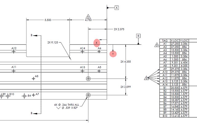
I think what Bob would like to do is generate a table as shown on the right in this screen grab. In this drawing, 0,0 is at the upper right corner of the part. I would find that useful from time to time as well.
-
Dear David,
That is exactly what I should like my friend.
I suppose TIG's plugin would go half way there if I were to insert negative as well as positive numbers into the datum dialogue box. With reference to my previous example, if I had entered -5,-10,-10 instead of 5,10,10, then the point at 5,10,10 would have appeared as 0,0,0 instead of 10,20,20, and so perhaps it just a matter of using the plugin correctly. I will try out the idea tonight.
Another idea: If the datum dialogue box had a 'query' icon/button that one could click on and then query a point, and with the datum field automatically filled after selecting a point, then that would be really helpful. Now, how lazy can one get!!!
Kind regards,
Bob -
Dear Bob,
I figured that would be your goal. So, while we're heaping work on poor TIG...
Suppose the plugin worked something like this:
Open the component for editing.
Select all of the geometry with a triple click of the Select tool.
Start the plugin.
The plugin identfies all of the circles and arcs in the selection and places a cpoint at center.
After that job completes the user clicks on the desired cpoints and the plugin places text tags. the text is A1, A2,...An. Perhaps you hit the up arrow to increment the leading letter in the tags.
All the while the user is clicking and placing tags, the tag and the coordinates are being collected by the plugin.
When the user clicks Enter or something the plugin pops up a message indicating that a CSV file has been saved to the same directory in which the SKP file has been saved.As always, I can dream them up but it takes a wizard like TIG or Thomas or someone else that isn't me to figure out if and how it can be done.
-
TIG, another BIG thank you.
-
Thanks for the feedback... My new Uni lecturing commitments will delay things until say Wednesday next week - but please post any other comments / ideas in the mean while...
-
Dear TIG,
What university and waht subject?
Thanks for all your help.
Bob
-
@watkins said:
Dear TIG,
What university and waht subject?
Thanks for all your help.
BobAt my old Alma Mata - Newcastle upon Tyne, School of Architecture - it's the 'SketchUp and Ruby Scripting' module for ~16nr year-5/6 'masters' students [I did a little bit last year too] ... it least until the new year... then the funding will probably evaporate with the latest round of 'cut-backs'...
-
Hi TIG:
1- Running SU8, PC, XP. My VCB doesn't display anything
2- I already have models to which I have used #heightool.rb (and labels).
Could one of the following be done?
Change heighttool.rb so it uses the same model tag variable (converts the old tag to the new).
or
Combines both into one ruby with the option to display the Z value only in the labels? (converts any existing heightool tag to a coordinate tag).Regards, John
-
Here's v1.2 http://forums.sketchucation.com/viewtopic.php?p=284829#p284829
It totally revised and updated with many more options and settings.
Please read the note in the linked post... -
Here's v1.3 http://forums.sketchucation.com/viewtopic.php?p=284829#p284829
An additional option to Export all of the Coords-Tags to a CSV file is added.
See the notes in the linked post... -
Excellent, TIG. This works quite nicely. I'll bet Bob will be pleased.
-
Thanks TIG again; this CPoint enhancement is very essential for me!
(Now if I could also add CPoints/Coord-tags by inputting into a box the XYZ values...)

-
@gaieus said:
Thanks TIG again; this CPoint enhancement is very essential for me!
(Now if I could also add CPoints/Coord-tags by inputting into a box the XYZ values...)OK, OK...
What format would the input be would you want it to reflect your current Coords-Tag Settings ? -
Dear TIG,
I have just noticed this post. Many thanks for all you efforts, and the continuing development of this plugin.
I will look at it more detail when I get home.
Kind regards,
Bob -
@tig said:
What format would the input be would you want it to reflect your current Coords-Tag Settings ?
Well, when I have already set the co-ordinates (say for example) X=1000, Y=1000, Z=1000, I then wish to place guide points (maybe with an option to receive a tag - or a tag with the option to add a CPoint)) to say (again, with the above example) at 2000/2000/2000 which in this case would of course be only at 1000/1000/1000 relative to the model origin.
To make the example clear; when we have the chance to dig "cleanly", we generally work in a 10m x 10m (or 5mx5m or whatever) grid system (where we keep section walls between these rectangular pits). This grid system is set up according to our national orthographic grid system so whenever I find a Roman coin (again, for instance), we take the exact location with those surveying tools.
Now when I set up an excavation with a grid plugin (there are lots of fine ones) and I want to quickly display the (already) known location of this coin, I could then have an input box to enter the xyz co-ordinates (maybe a yes/no for an additional CPoint) rather than trying to guess where it is.
In other words; what the plugin already does just vice-versa.
And of course, I am already very grateful and would not "urge" you in any way...

-
Here's v1.4 http://forums.sketchucation.com/viewtopic.php?p=284829#p284829
It fixes a glitch with incorrect reading of the Datum.
It also adds two new tools:
Import Coords-Tag from CSV [optional units and optional cpoint]
Add Coords-Tag by Dialog [input XYZ and optional cpoint, using current units' settings]
Please read the notes on the download page as linked... -
Hi TIG and many thanks again but what I would need is not exactly this.
First of all, the add coord tag by input seems to add the tags in inches (2.54x farther than needed).
The other thing is that these points are now added relative to the current origin (that would also be cool in fact but then I could simply use 0/0/0 as my origin). What I would need is to add the coords according to the modified origin co-ordinates. So if I am 800 kilometres away from our national origin (that is somewhere in Slovenia, Austria or Italy AFAIK
), and add a coord at 800.000.125 - or 800,000,125 on my Hungarian keyboard system (i.e. only 125 centimetres from my model origin), it would be just 125 cms from my origin.
-
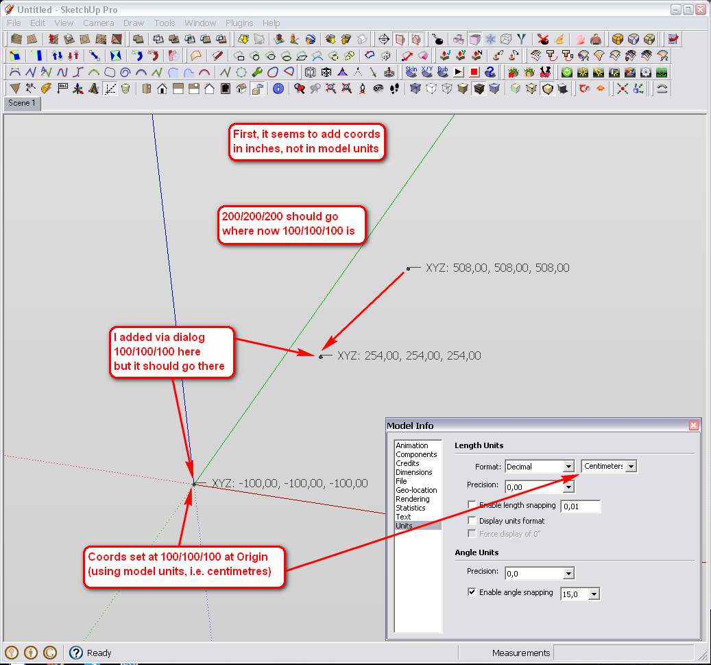
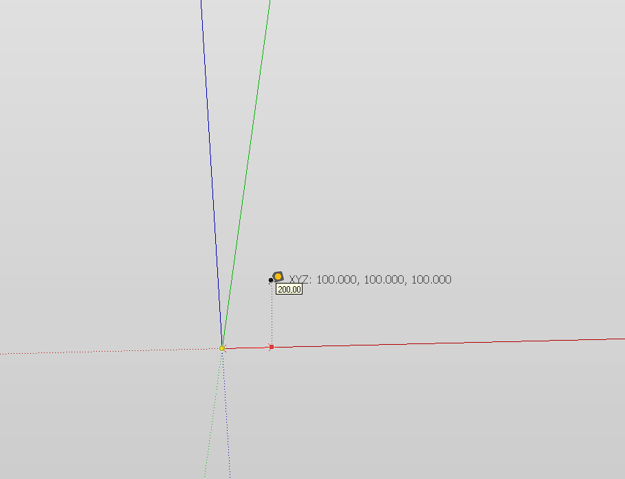
Wait a minute, something else is also wrong here. My model origin is not at 100/100/100 but all negative; -100/-100/-100!
I tried again and indeed it sets it to negative!
-
Some correction/modification...
It only works in inches if I set the coords in model-units. Although I have centimetres in my template, it doesn't seem to recognise it.
Then if I set the units to centimetres, it will correctly add the coords - except it swaps my origin from + to - (see screenshot) and does not add the coord tag where I wish (so what is written above is still valid).
Hello! It looks like you're interested in this conversation, but you don't have an account yet.
Getting fed up of having to scroll through the same posts each visit? When you register for an account, you'll always come back to exactly where you were before, and choose to be notified of new replies (either via email, or push notification). You'll also be able to save bookmarks and upvote posts to show your appreciation to other community members.
With your input, this post could be even better 💗
Register Login


Advertisement