Couple of hours maybe (didn't really pay attention to how long it took)
Oops, your profile's looking a bit empty! To help us tailor your experience, please fill in key details like your SketchUp version, skill level, operating system, and more. Update and save your info on your profile page today!
Sketchucation Tools 5.0.7 | Licensing improvements and bug fixes Learn More
R
Offline
Posts
-
RE: Messing with ffd
-
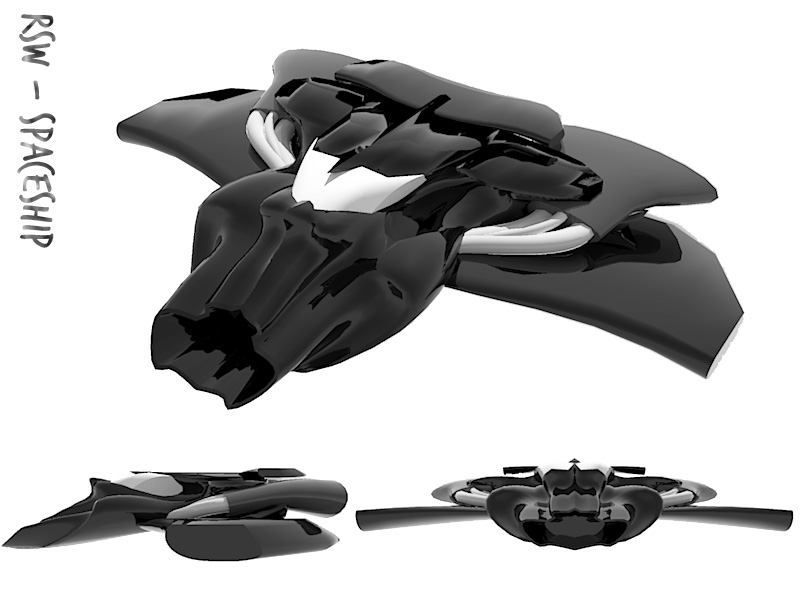
Messing with ffd
I was just messing about with shapes and ffd, and ended up with something that resembled the body of some sort of spaceship. Wings and a few other additions and it turned into this...
-
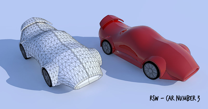
RE: Another car...
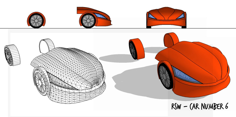
ok, this one is very similar to the previous, but this time I've tried starting with a low poly mesh and using sub-divide and smooth on it.
-
RE: Another car...
@plot-paris said:
wow, very impressive! could you tell me, how you get the curves where you want them to?

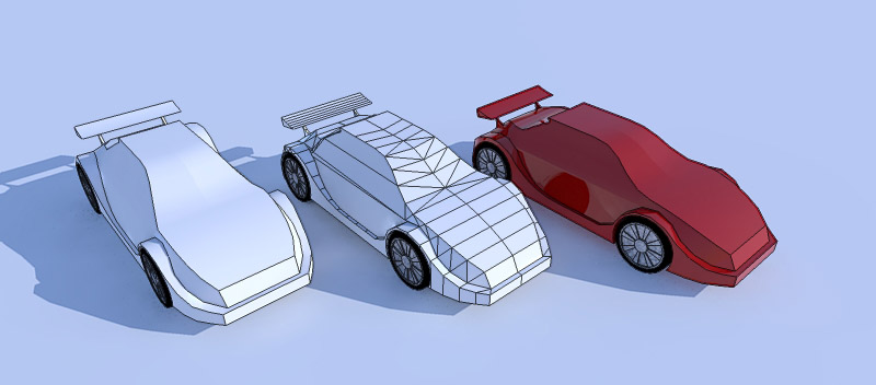
(what do you use to achieve these smooth forms? Subdivide&Smooth?)For the last one the bonnet was done with FFD to begin with (using some additional curves as guides for the FFD points), the bottom section/bumper was created with follow me to start with and then FFD. After that I did quite a bit of manual manipulation of points and drawing of curves to fine tune the shapes. The lights were a combination of manually drawing shapes, offset on surface and JPP. To be honest its a bit of trial and error at the moment.
-
RE: Another car...
Just the front end of a car today.. spent a bit more time with this one, getting the curves to go where I wanted them to...
-
RE: Another car...
thanks for the comments so far.
Heres another one...
Really enjoying doing these. -
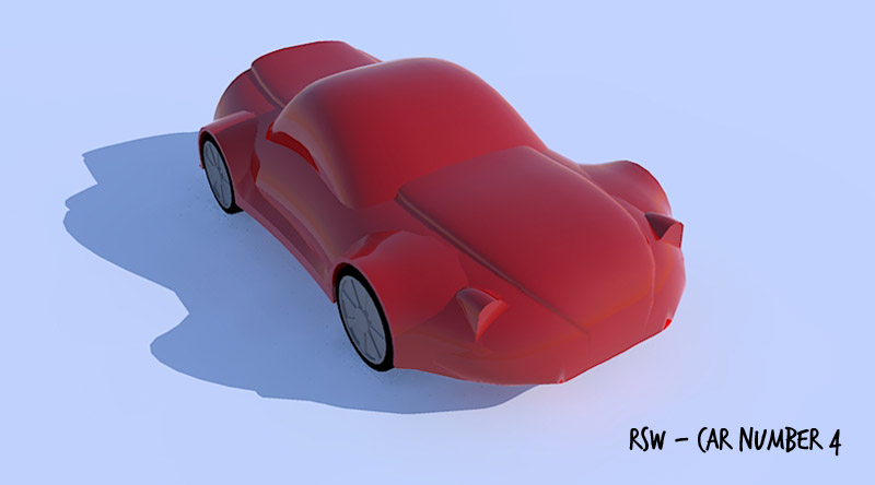
RE: Another car...
And another...
Getting the hang of these now... Think thats all for today though! -
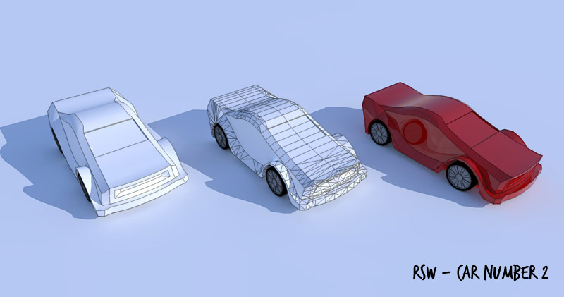
Another car...
Everyone else seems to be doing it, so I thought I'd have a go at modelling a car as well - Tried it before but never really got that far, but had a go today and seemed to come together better.
Just a fairly quick try,nothing too fancy, but I quite like it...
B.skp -
RE: Merging two shapes along path...
@unknownuser said:
I don't know of a method to do this instantly. However, I would make my start and finish shapes, apply the skin ruby and use FFD to bend it.
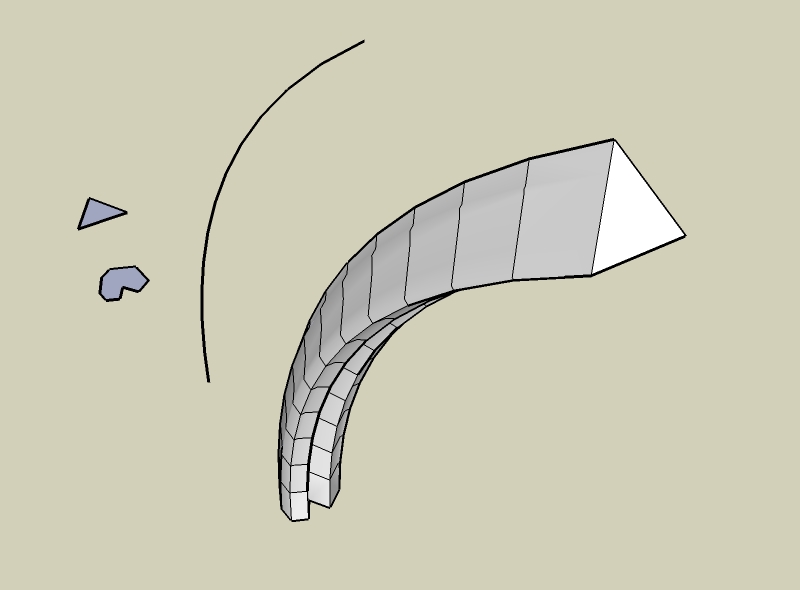
Yep, FFD seems to be the easiest way. Although to begin with I was having trouble aligning the control points to the curve (especially if I wanted to define a line within the shape to use as an axis. But I realised that you can just add a line within the group of control points.
I prefered to manually skin the shapes as you have better control over the tramsition of the shapes.
Also using FFD it is easy to introduce rotation of the shape as well.
I'm sure much of the following could be automated
my method of using FFD to merge from one shape to another along a given path -
Merging two shapes along path...
I was reading another thread (can't remember which one) and it got me thinking whether it was possible to merge one shape into another along a given path. Something similar to the pipe along path, but changes the shape as it goes along.
I had a go at manually doing this, but although reasonably simple (at least it was with the shapes I used) it is fairly tedious.
I don't know anything about ruby, but I would have thought I ruby script could be made to do something like this.
 test.skp
 -
RE: An Accidental Abstract
Really interesting stuff! excellent!
To me it looks like it could be some crazy hair / a wig of some sort...
-
RE: [REQ] Multiple copy
you can copy with a basepoint
a) copy your object
b) paste object (su will choose a basepoint initially)
c) pasted object will now be selected, with move command active - move object using your preferred basepoint (just clicking on the basepoint and escaping from move command will suffice if you don't actually want to move the object)
d) paste again and su will use your chosen basepoint for inserting your object.Not sure if thats what you want...
-
RE: SketchUpBBS Gallery
Excellent images.
I would also like to know how you've achieved the grass. -
RE: Procedural terrains
@rsw said:
(unless you know how to improve this?)
Forget that, zoom in closer in GE and import into SU, then move along in GE and import into SU again, repeat until you've got the area you want (doesn't give a single terrain object and seems to import image as greyscale but is more accurate).
Can't believe I missed that

-
RE: Procedural terrains
@gaieus said:
This site uses GE terrain data, doesn't it? (at least to me it seemed so). What way is it better then than importing terrain from GE?
It grabs the elevation data from usgs seamless elevation data sets, which includes SRTM data (among others) According to wikipedia GE uses srtm data and supplementary dem data to fill gaps. So that site does use very similar data to GE.
As you will see from the skp below there is a difference in the geometry obtained from GE and from this site.terrain compare.skp
The geometry from GE is lower detail - (unless you know how to improve this?)Anyway I was just experimenting to see what could be done
-
RE: Procedural terrains
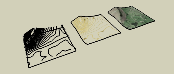
Another go at creating an accurate terrain and came up with this:
Created this by using this site to create a 30x30 grid of lat, lon and elev data.
Converted the lat/lon to UTM (meters).
Imported into su with the points cloud ruby.terrain quick.skp
Solo, I thought that using the srtm data with 3DEM to give images like this
 and used with your method could produce some good results...
 -
RE: Procedural terrains
@solo said:
Below I used a photo and tried the straight .jpg to displacement method, it is not accurate but still a pretty cool looking result.
Definitely a cool result, and very interested in how you are getting from the jpg to the su mesh.
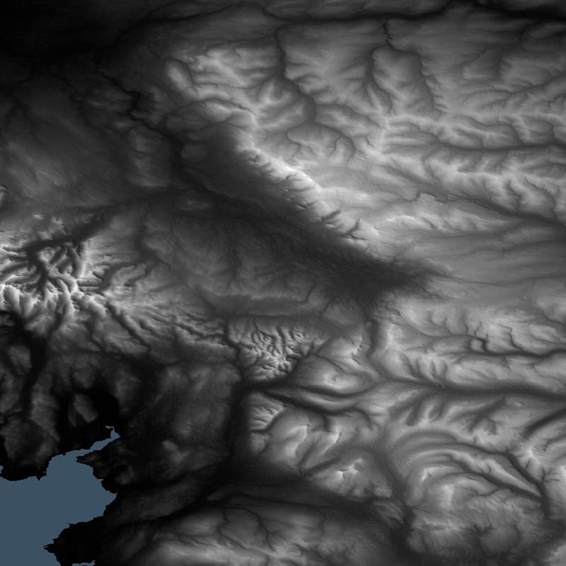
Had another go at extracting the contours from google maps terrain images, with the following result:
Tidying up and assigning heights to each contour is tedious for large areas but not bad for smaller sections. I used the contour maps from http://www.earthtools.org/ which are in metres rather than googles which are in feet. This says that these contours were generated from data, if we could find out how the contours are generated maybe they could be imported straight into su... -
RE: Procedural terrains
Probably doesn't help much, but here are my thoughts on this...
One thing I notice from your experiments with GE images is that the end mesh is not accurate (in my opinion).
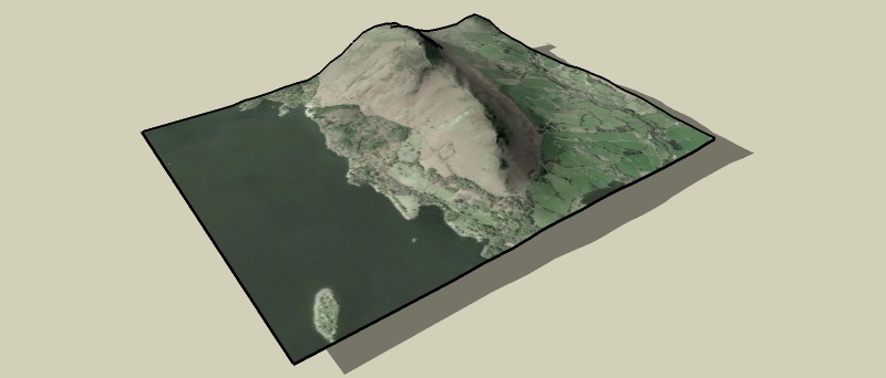
Particularly noticable to me is your first ge image of scotland. The lochs appear to have very steep sides, which may be correct in some instances, but also the lighter coloured area is a mountain (An Teallach I believe) but there does not seem to be much height difference relative to its surroundings as I would expect.
I assume that the mesh is generated by colour of the ge image??
ge/gmaps does seem to have detailed elevation data (google map showing part of the same area of scotland showing terrain with contours), but it doesn't seem like this can be easily exported.
I attempted extracting these contours with raster to vector software, but needed quite a bit of time to tidy up to be of use, although the end result seemed reasonably accurate, especially with the gmaps satellite image added as a texture.
I will keep an eye on how this progresses (particularly if you are trying to create an accurate model)