HI.
The SightSpace 3D app for iPad was released today. Any one tried it yet?
HI.
The SightSpace 3D app for iPad was released today. Any one tried it yet?
Hi Robert.
My name is Javier and I'm and architect and an astronomy enthusiast. I have just read you post called "Astronomy software?" and very interested on what has been the outcome of your project. I’m also interested because, as you can see on these threads:
http://forums.sketchucation.com/viewtopic.php?f=323&t=27436
http://forums.sketchucation.com/viewtopic.php?f=180&t=27480
about astronomy and sketchup, I was asking for the same thing as you have. My idea was trying to do a plug-in or extension, but after some time only achieved a plug in called "Face Sun" (thanks to thomthom) and thanks to Gabriel at the forum of http://cerebralmeltdown.com another plug in to place a face according to Azimuth and Altitude coordinates.
Besides asking you about your project (that must be a very interesting one), I want to know if you have had luck finding an astronomy software for Sketchup, or if you have find more info about the image of your post. And about this image, when I saw it I just knew I had to share with you a similar image because it also joins astronomy and architecture. It is a project I did for a contest in Nazca, Peru. You can see in the image how the building is aligned so the sun can show trough openings in special dates. Thanks in advanced for any answer.
Hi Chris.
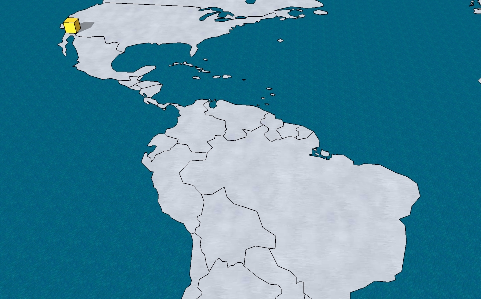
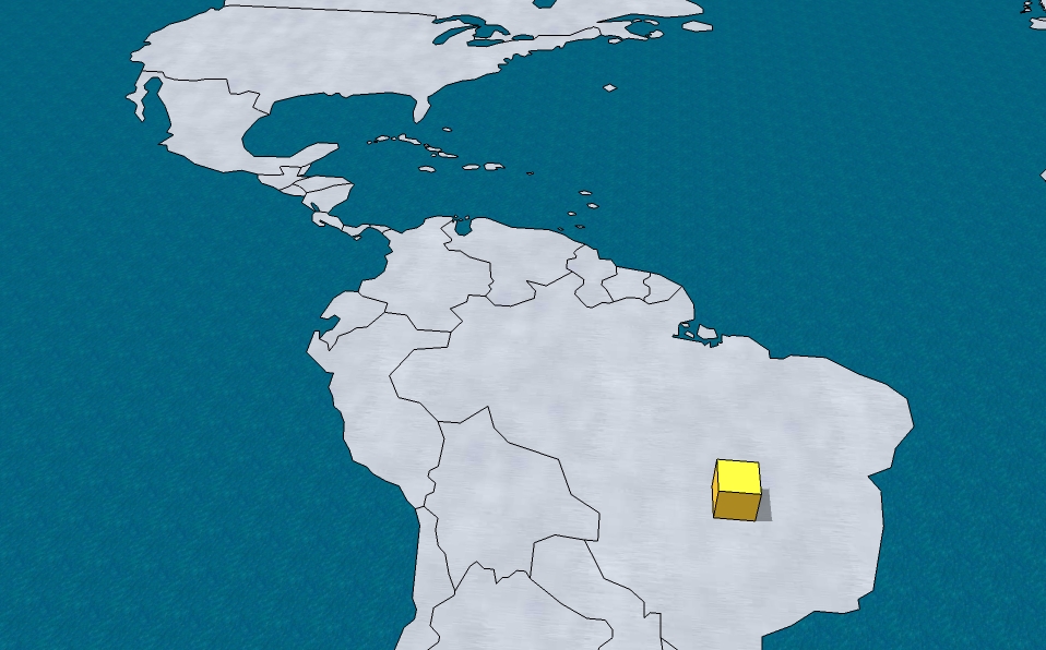
The map in the image is a model I downloaded from the Sketchup warehouse. I'm attaching it to this post. By the way, you have some great video tutorials at youtube, I was watching them before reading your reply.
@chris fullmer said:
Sure, it might be able to be done. Changing the shadows when the cursor moves is probably do-able. Mapping the coordinates of the map to the altitude/latitude and timezone is another matter, and probably rather time consuming. It could be an interesting project though if someone really wanted to tackle it.
And actually I think that your first example might be able to work. Do you have a nice model with a map built into like the one in your images? It might be easier to play around with if the map was supplied.
Chris
Hi again.
Well, it has been 5 days without a single reply, so I will take it as a "No, it can't be done". Still, I'm wondering if it can be done in a different way. Let's forget about moving the object, lets say it stays put. Knowing that there are sliders that can change the date and time and see in real time how shadows change, can a "slider" be done that changes the location coordinates? BUT, instead of having sliders, can the coordinates be inputed by sliding a cursor over an image of a world map and, as the cursor moves over the world, see how shadows change depending on the cursor coordinates? Thanks for any info anyone can provide.
Hi.
I’m interested on making a tool in Sketchup that can show in a very graphical manner how the behavior of shadows is determined by location, this is for academic purposes. The idea is that, instead of inputting the location coordinates on a dialog box and see the shadow output on a fixed 3D shape, I would like to move that shape over a map and see how it’s shadow changes as it’s been moved around the world (see pictures). Have this been done before or is it possible? Thanks for any help.
Hi Chris:
It's not the 3 chapters, it's the complete book.
@chris fullmer said:
Its only the first 3 chapters that are available actually.
But the business model you mentioned is not uncommon. Many authors (ok, well a few authors) publish something entirely online for free, or you can buy a hard copy if you want a tangible copy to hold and touch.
Chris
Automatic Sketchup book can now be freely be downloaded
Hi.
Just wanted to let everybody know that Matthew Scarpino's book Automatic Sketchup can now be freely download at
[link removed]
Read this announcement from Matt himself at
[link removed]
in the May 18 post.
About the book from it’s site:
Automatic SketchUp
Google SketchUp has become one of the most popular tools available for three-dimensional modeling. Its users include architects, engineers, woodworkers, and hobbyists from all across the world. Most designers rely on the toolbar and menus, but SketchUp provides a programming interface that makes it possible to construct designs with scripts coded in the Ruby language.
Automatic SketchUp focuses on this Ruby interface, and explains how to write and execute scripts in the SketchUp environment. With scripts, you can not only form lines, points, and surfaces, but also access advanced features such as animation and web dialogs. You can create custom plugins that extend SketchUp’s capabilities with new tools, menu items, pages, layers, and dialogs.
Automatic SketchUp takes a step-by-step approach to presenting this powerful programming interface, and begins with a simple introduction to the Ruby language. Successive chapters build upon one another, and each provides a wealth of example code to demonstrate the concepts being presented.
Regards.
[mod=Rich:1gkktdzw]Removing suspicious links[/mod:1gkktdzw]
Hi Morisdov:
As I wrote on the first post, one of the uses of the plugin is helping in the research of how the bodies in the night sky can be used to contemporary design (please do not mistake this for astrology). So a lot of rotating goes along, orienting a single face to various points in the sky until finding the right one. Since this thread, I have simplified my request of the plugin here:
http://forums.sketchucation.com/viewtopic.php?f=180&t=27876
Regards.
@morisdov said:
Hi Javier, I cant guess which faces in your 3D model should have the ability to reorient themselves towards anything.
The "archeological site construction" which is the only 3D model is frozen by history and must be locked for any changes whatsoever.
you should place in that 3D model many Skethcup "cameras" and orient only them to face certain directions towards the sky at a certain date and time point. (like the sky of the longest day of year 500 BC or 1492).
You can ANIMATEvia sketchups standard view animation features to "look" form the cameras - this will be your demonstration of this whole idea.You may add lines from the cameras to the cameras target point(star in the sky) to emphesize and "prove" and "explore" that the archeological site was indeed constructed in ancient times in accordance and perspective related to stars positions of specific dates and times.
As an unrelated side note - i recommend exploring when "perspective" was first "invented" in each cultures paintings
Cheers, Moris
Thanks Kyyu, will try it out right now.
Javier
@kyyu said:
This should get you started. I really can't help you more. It just happens, I am researching something similar, so familiar with the rotation commands. I am starting from your 2nd picture and assuming the plane normal is the green axis. The simple script just rotates whatever is selected with the assumed normal. About the origin, 30 deg and then 50 deg. So just select the parts, and type this into the ruby console to run the script (correct the path to where you have the script):
load 'c:/Rotate_Plane_example.rb'
Hi and thanks for everybody who has taken the time to read my post. I'm not a programmer but would like to make this plug-in, so I'm wondering if someone can help me find similar plug-ins or codes that would help me understand and program it. Thanks.
Hi and thanks for everybody who has taken the time to read my post. I'm not a programmer but would like to make this plug-in, so I'm wondering if someone can help me find similar plug-ins or codes that would help me understand and program it. Thanks.
Hi.
I’m looking for help to have a plug-in that aligns the Zaxis of a plane to a pair of specific coordinates. The use will be:
a) Select a plane.
b) Input an Azimuth and Altitude coordinates, and the result would be:
c) The plane would turn itself to face that coordinates direction by aligning it's Zaxis to such direction.
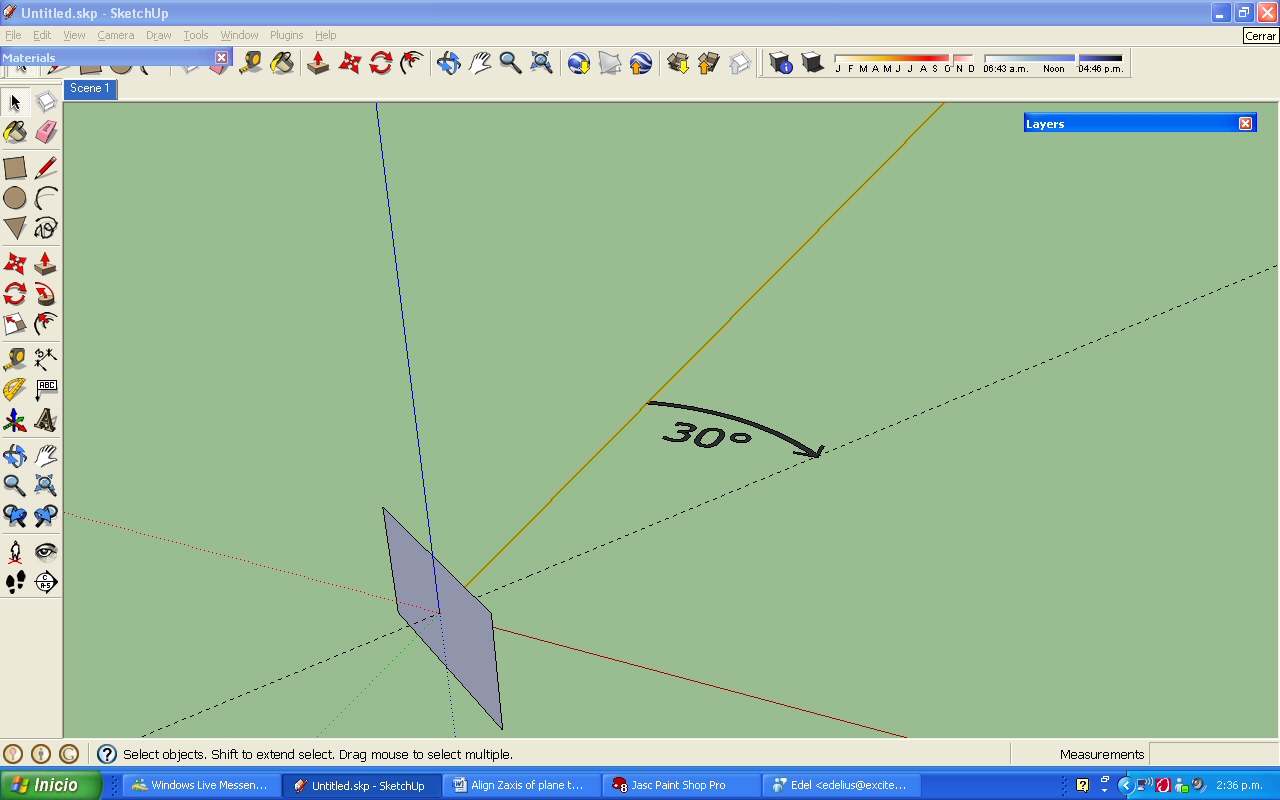
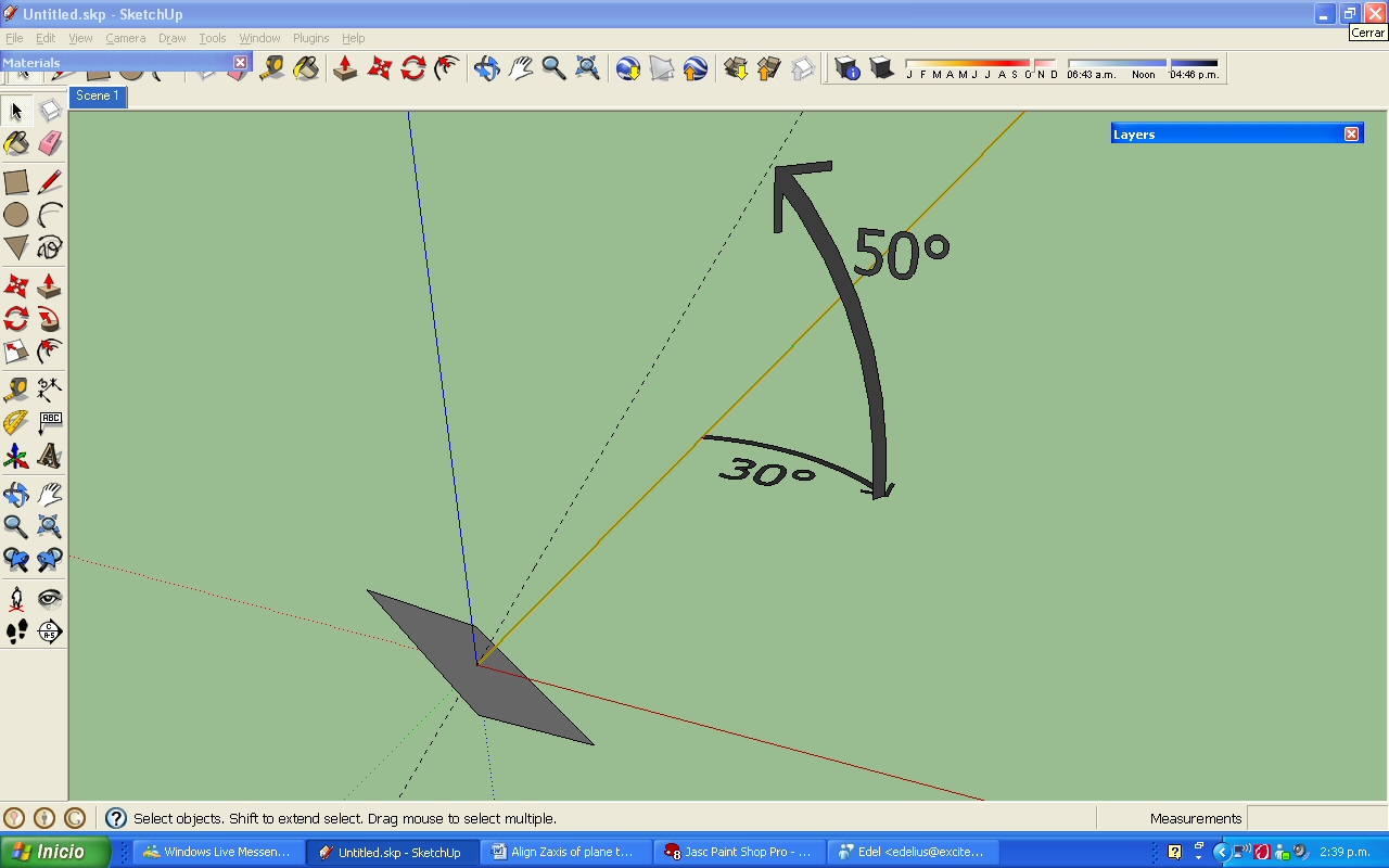
Azimuth and Altitude are two angular measurements and work as follows. Suppose we want to align the Zaxis of a plane to coordinates Azimuth 30° and Altitude 50°:
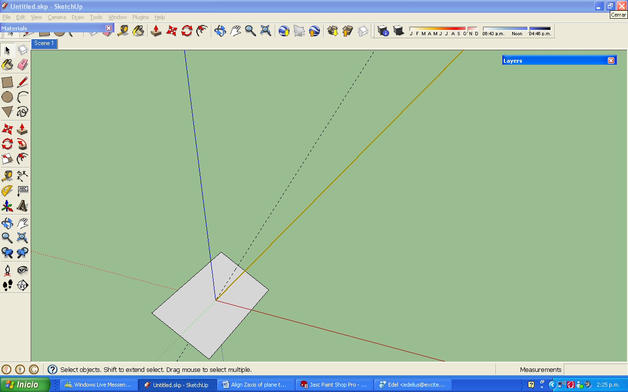
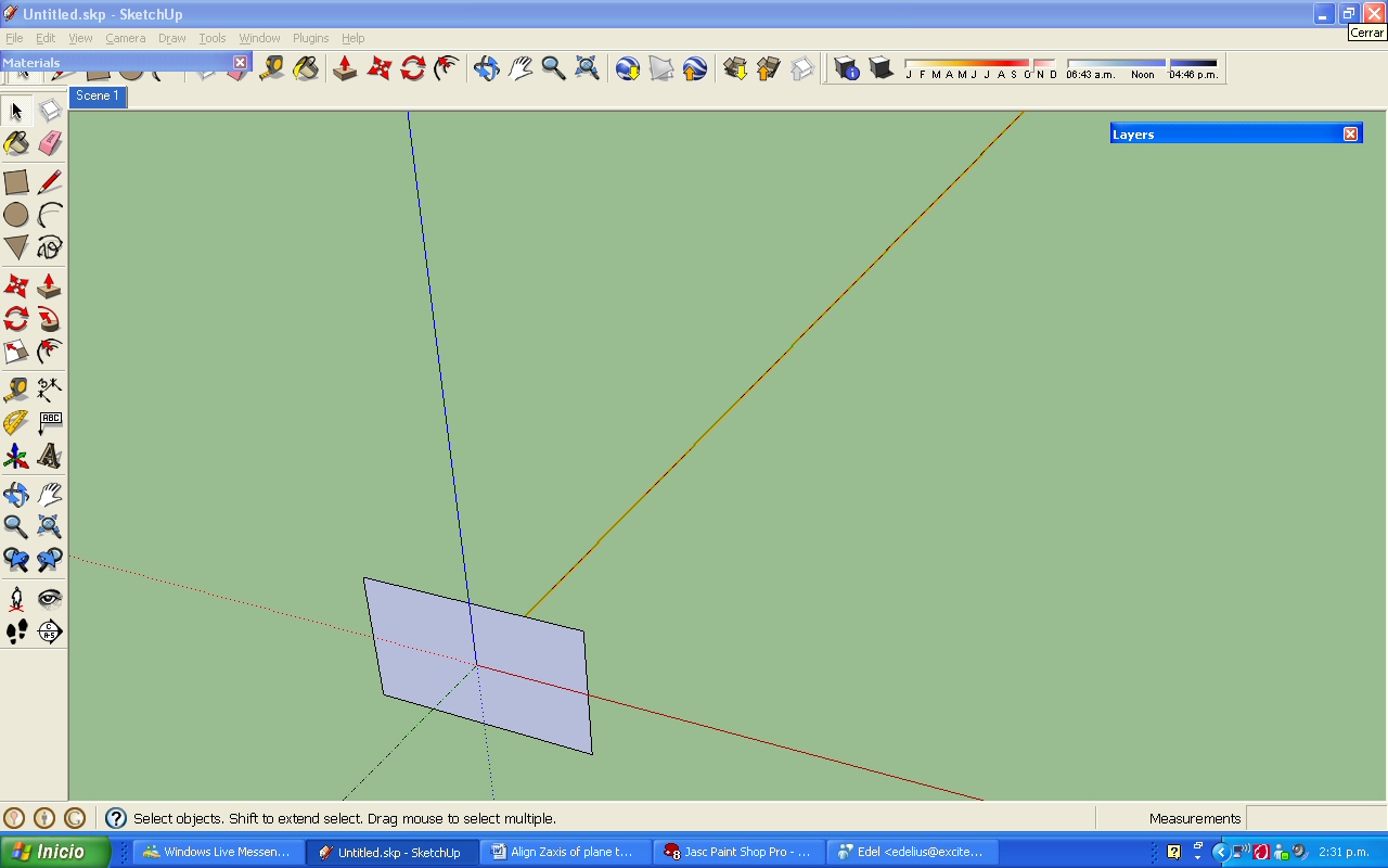
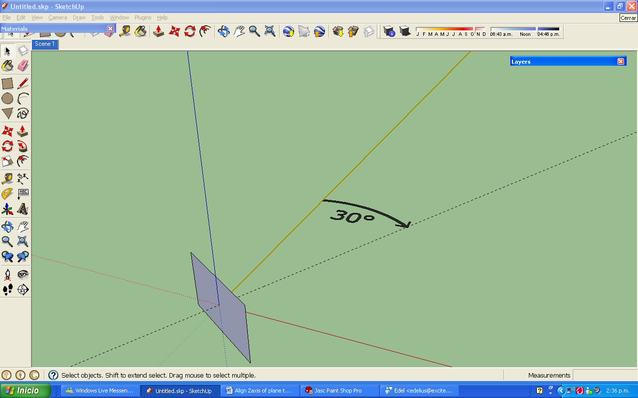
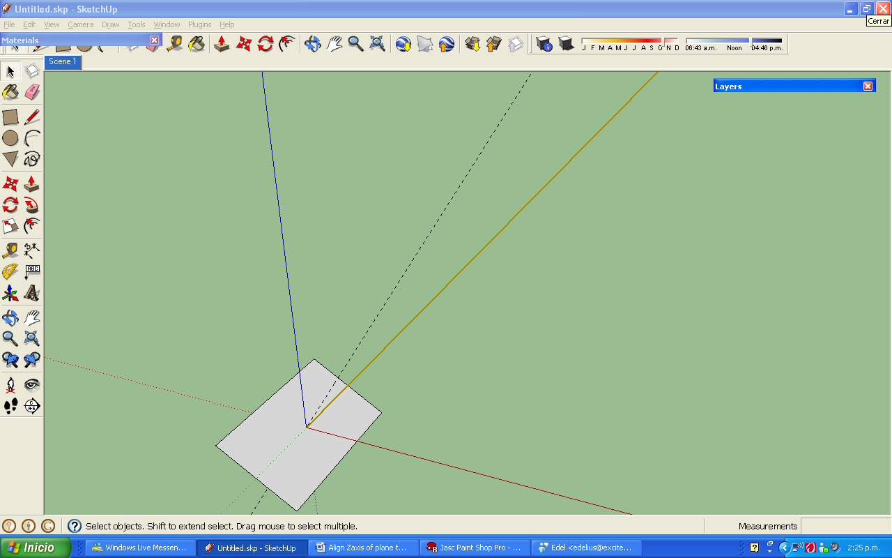
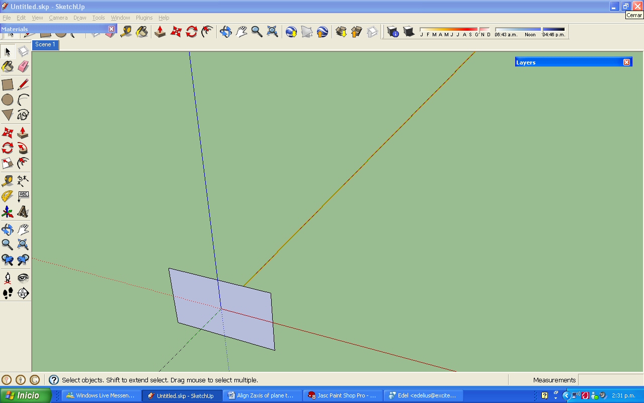
a) We have that plane pointing its Zaxis to a random direction (Fig.1). For clarity in explanation, in Fig. 1 the Zaxis is represented by a vector located at the center of the plane, and the intersection of the vector and the plane is at 0,0,0. Sketchup north is aligned with the green axis.
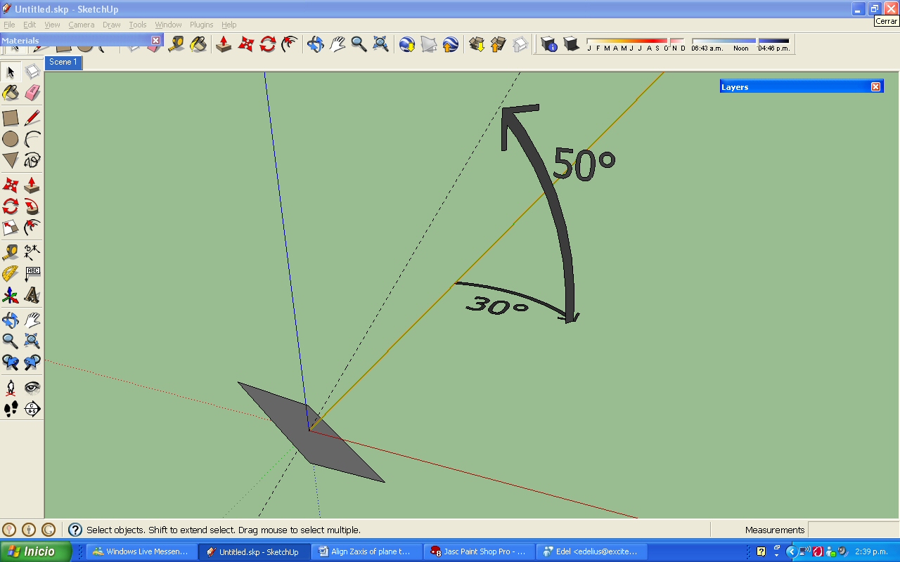
b) First, the Azimuth. The Zaxis Azimuth starts always aligned to Sketchup North, flat on the ground (fig. 2). North direction is 0°, and starts to rotate towards East. So, when it reaches East it has rotated 90°, when South 180°, West 270° and North 360° or 0° again. For our example, Zaxis turns to the East just 30° (Fig. 3).
c) Then Altitude. Altitude is the angular measure the raises the Zaxis from the ground. For our example, Zaxis raises from the ground 50° (Fig. 4).
That’s it. Now the plane is facing Azimuth 30° and Altitude 50°.
Two last things. In this example north is the same as the green axis and the face is at 0,0,0, but it will not always be the case when using the plug-in. Thanks in advanced for any help.
Javier
The email server is up and running again, just received my trial key. Just wanted to inform this for anyone who had communication problems with the site and/or with it's admiminstrator.
Thanks Utiler for your forward. I have asked directly trough his website but also no reply. Hope to get an answer, it looks like a really great plugin.
Hi.
I’m writing just to ask if somebody had requested recently a trial activation key for the 1001 shadows plugin at:
http://www.1001shadows.com/en/index.html
I’m interested in giving it a trial try before buying it but after more than 48 hrs of sending a request mail I have not received the trial activation key (searched even in my spam folder). Has anyone requested recently a trial activation key and had the same problem? Does anyone know if the site is active? Does someone of the site is a member of this forums and can read my mail for an answer? Regards.
Dan, no astronomy, no calculation, no ancient dates are needed, no RA and DEC anymore. I'm using another coordinate system that uses SU horizontal plane and north. Please read this post:
http://forums.sketchucation.com/viewtopic.php?f=180&t=27480&start=15#p238823
I will do all the astronomy, calendar calculations and math. Just need a script that tells a vector to rotate around blue axis given an angular measure and then raise that vector with another angular measure as I explained with the pictures in the post, and lastly align the Zaxis of a given plane to the vector. Thanks Dan and all you people that are investing their time to help.
@dan rathbun said:
@chris fullmer said:
I think none of us want to learn how to calculate the position of the stars 8,000 years ago.
Besides it cannot be done in Ruby. Standard Ruby (and Sketchup Embedded Ruby,) use the included class Time which has an initial date of January 1, 1970 CE(AD). I have tried to set Sketchup dates before this, and the app does not allow it. (In addition, the MAX year is 2037.)* The ShadowInfo['ShadowTime'] attribute takes and returns only Time class. (It actually does not not raise an Exception if you say give it an Integer, but the value will be unchanged.)
This post actually began over at GoogleGroups, and there I posted some info for the requester, that if he wanted to be historically accurate, the plugin would need to ignore Sketchup's built-in Sun positioning and Time keeping.
The plugin would need to keep it's own date and time (with a dialog to set them,) and the Moon (Luna) and Sun (Sol) would be treated as just stars (like all the rest.) In addition, the plugin would need to use the Ruby Extended class Date, which can go back 6723 years MAX, as the initial date is January 1, 4713 BCE (4712 BC, accounting for year 0).
- I would think this implies that future versions of software utilizing Ruby should move to using the Date class (and it's DateTime subclass,) sometime in the next 27 years.
I did a bit of checking, I'm looking for calculation software that runs on remote web servers, so a plugin could query that server for a particuler star's RA and DEC, from a specific geolocation and date; rather than do it itself.
I did find some code, at an Italian University but it's written in IPL, and would need to be translated to C or Ruby. I don't know IPL.
Great!
@chris fullmer said:
Aha! That can be done, and rather easily (more or less). I won't be able to get to it tonight, but if no one else gets to it, I'll try to do it by early next week.
Chris
That is the correct idea when you say that what I want is a script that orients a face to be perpendicular to a vector that is pointing towards a star. On the other hand, you don’t have to learn how to calculate the position of the stars thousands of years ago. It would be unfair of me that besides having your invaluable help making a script to expect from you to learn astronomy. I have the list of stars and its coordinates, so I will provide them and I enter them manually in SU. So no complex math, no astronomy, no mathematical expertise from your part, nothing to calculate, even forget all the astronomy theme of the previous post. Just need a script that tells a vector to rotate around blue axis given an angular measure and then raise that vector with another angular measure as I explained with the pictures in my last post, and lastly align the Zaxis of a given plane to the vector.
@chris fullmer said:
Looking at this last diagram of yours, it looks like you want a script that orients a face to be perpendicular to a vector that is pointing towards a star. Is that the correct idea?
The only tricky part is really figuring out how you have your data collected about what that vector is. If it requires math using old calendar dates, you'll need to find that info on how that math is accomplished (maybe you already postefd that?, I have not been following too closely). I think none of us want to learn how to calculate the position of the stars 8,000 years ago. You need to provide that expertise somehow. So if you had a link that explained it all out mathematically and simply (most of us are not serious mathematicians), that would be great.
And lastly, you must have a list of stars and dates you want to examine? Or you plan on entering that in manually? Or something. But you need to figure out how your data is organized and how you can get it into a useable list, that can be read by a computer.
Again, this is all very do-able (I've already written a script that orients a face perpendicular to any given vector called perpendicular faces, for example). Just help us with how to calculate the vectors better, and say how you want to input your data.
Hi again.
There is no need to have a point in x,y,z space representing a star, just a vector that is directed to it. If this vector starts at 0,0,0 of the Sketchup space you only need two angle measures to direct it to the star.
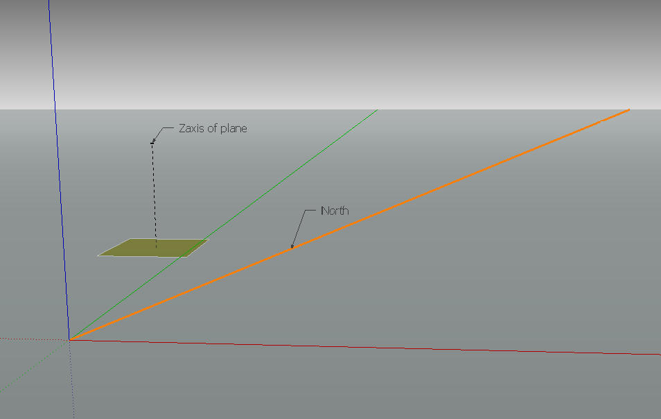
Let's say that an astronomy software tells that a certain star of interest has an Azimuth of 51.8 degrees and a Altitude of 42.0 degrees, and I want a plane's Zaxis to point to it. So we have the coordinates, a plane and a North (orange line in Fig. 1). Please note that the north can be at a random angle from the green and red axis.
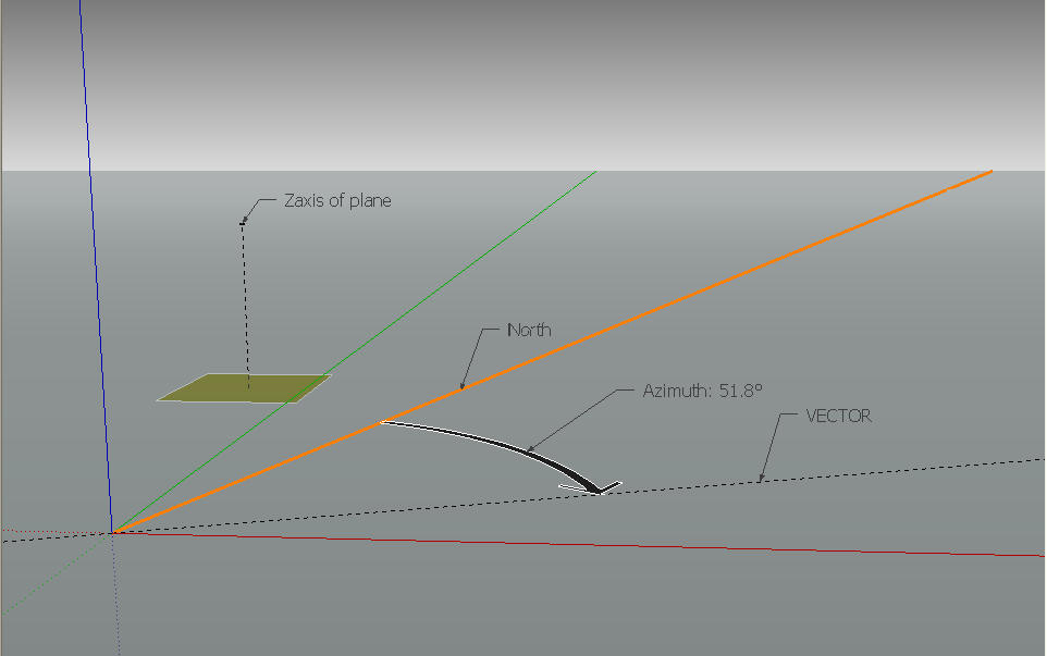
Then, starting from the north, a vector fixed in one of it's end to 0,0,0 starts to rotate around the blue axis counterclockwise (towards the east) until rotating 51.8 degrees. That is the Azimut of the star (Fig. 2). The vector is still in the horizontal plane.
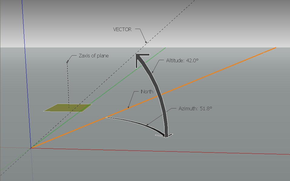
Then, this vector still fixed to 0,0,0 rises 42.0 degrees from the horizontal. That is the Altitude of the star (Fig. 3). Now the vector is pointing towards the star of interest.
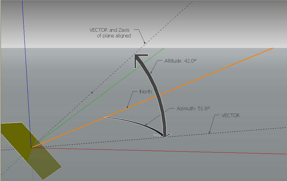
Now what is left is to align the Zaxis of the plane with the vector (Fig. 4).
That's it. Just make rotate a vector around two coordinates and align the Zaxis of a plane to it.
