Grand Tetons: Fredo's Topo Shaper
-
Fredo, Topo Shaper works great. Tried it out with a topo of the Grand Tetons which I created using the following steps.
-
Grabbed a topo map of the Grand Tetons from USGS.
-
Isolated the topo layer in the PDF and then printed that to file.
-
Cleaned up in Photoshop removing numbers and reconnecting topo lines.
-
Saved PDF and then ran through a trial version of Scan2CAD to convert it to a cad dwg.
-
Imported 2D cad drawing into SU 7 then opened in SU 8.
-
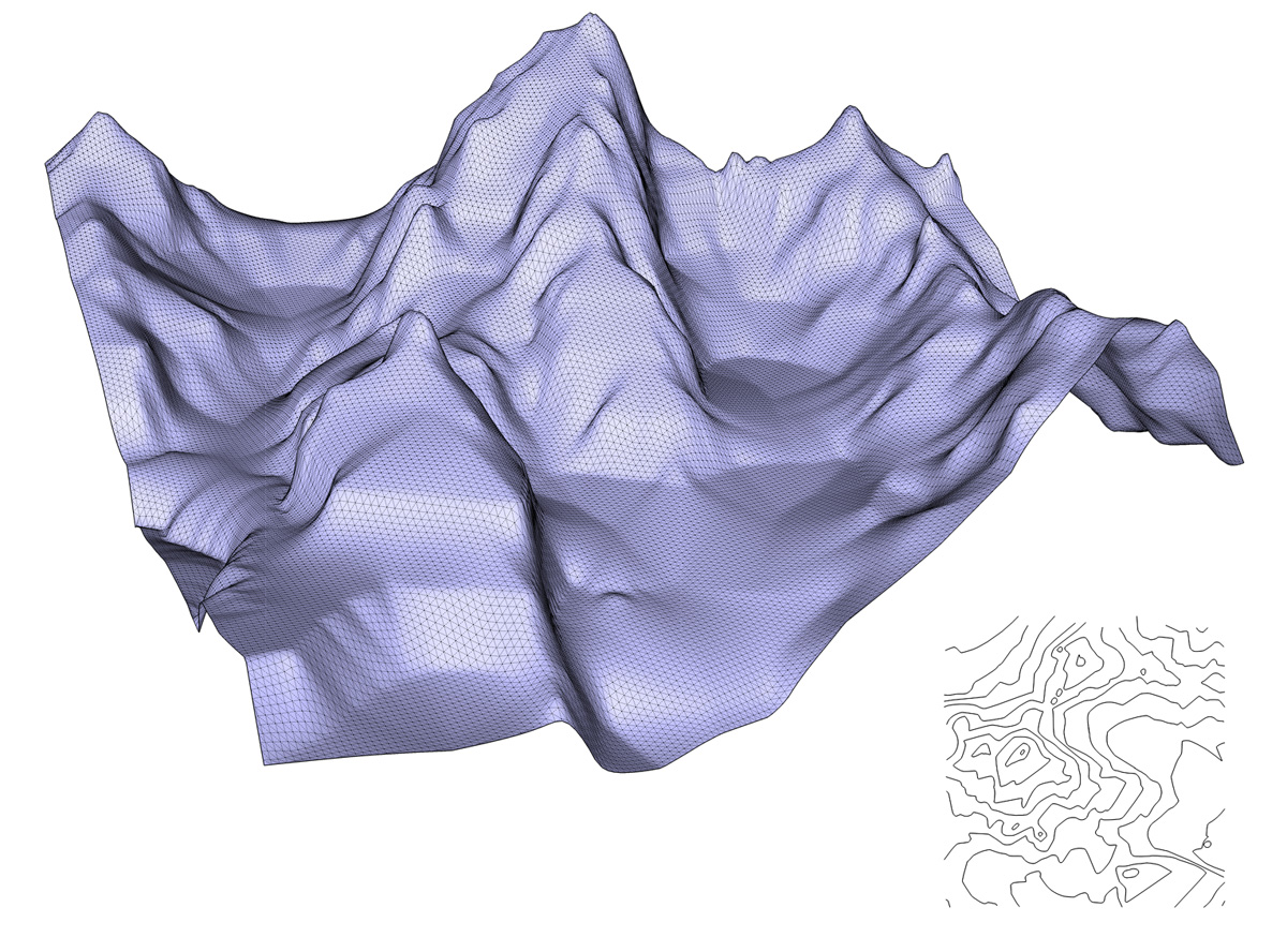
Add face to line work and then pushed or pulled each segment by 80 feet appropriately.
-
Cleaned up and deleted faces to isolate the topo line.
-
Ran it through Topo Shaper.
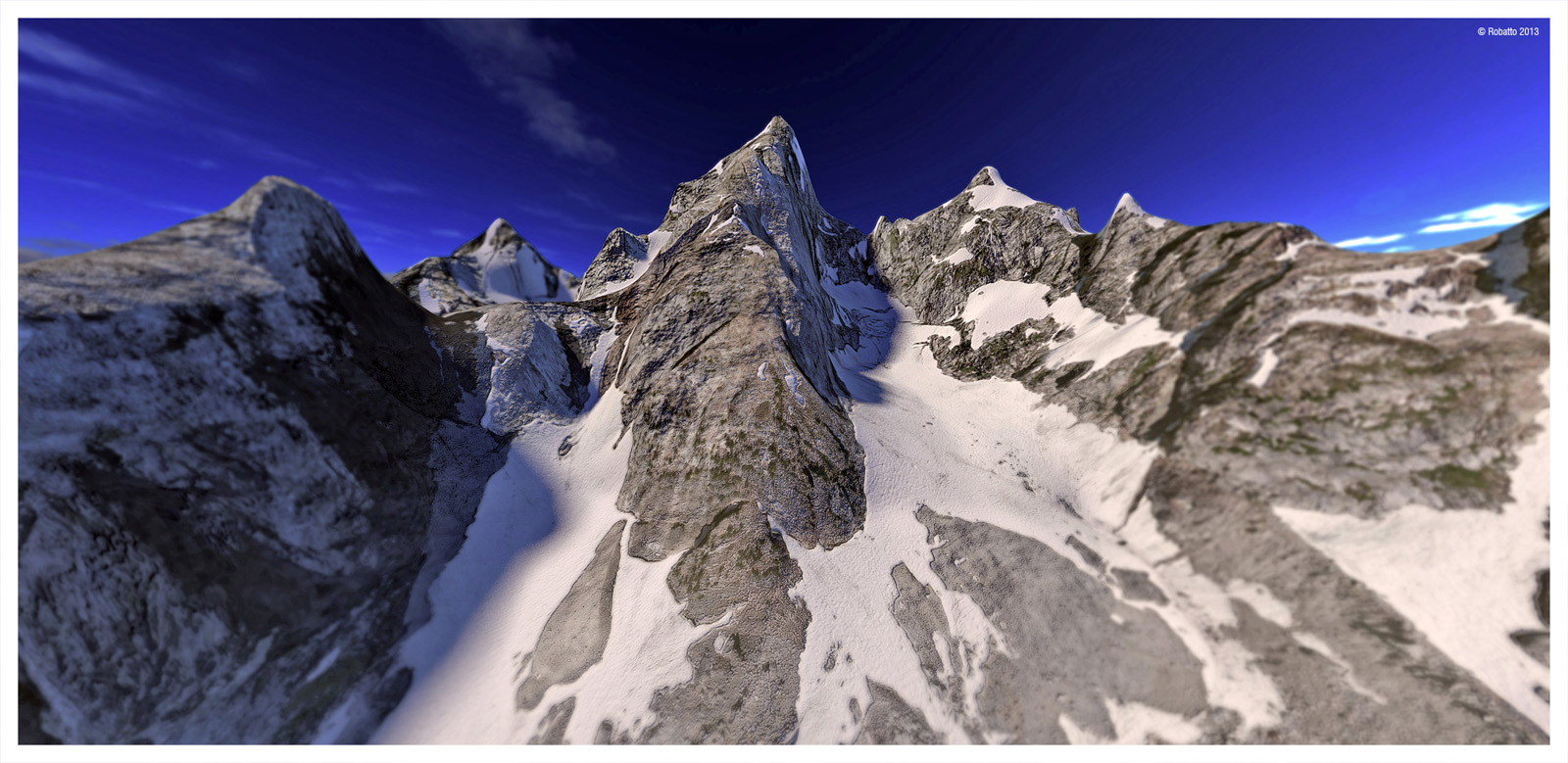
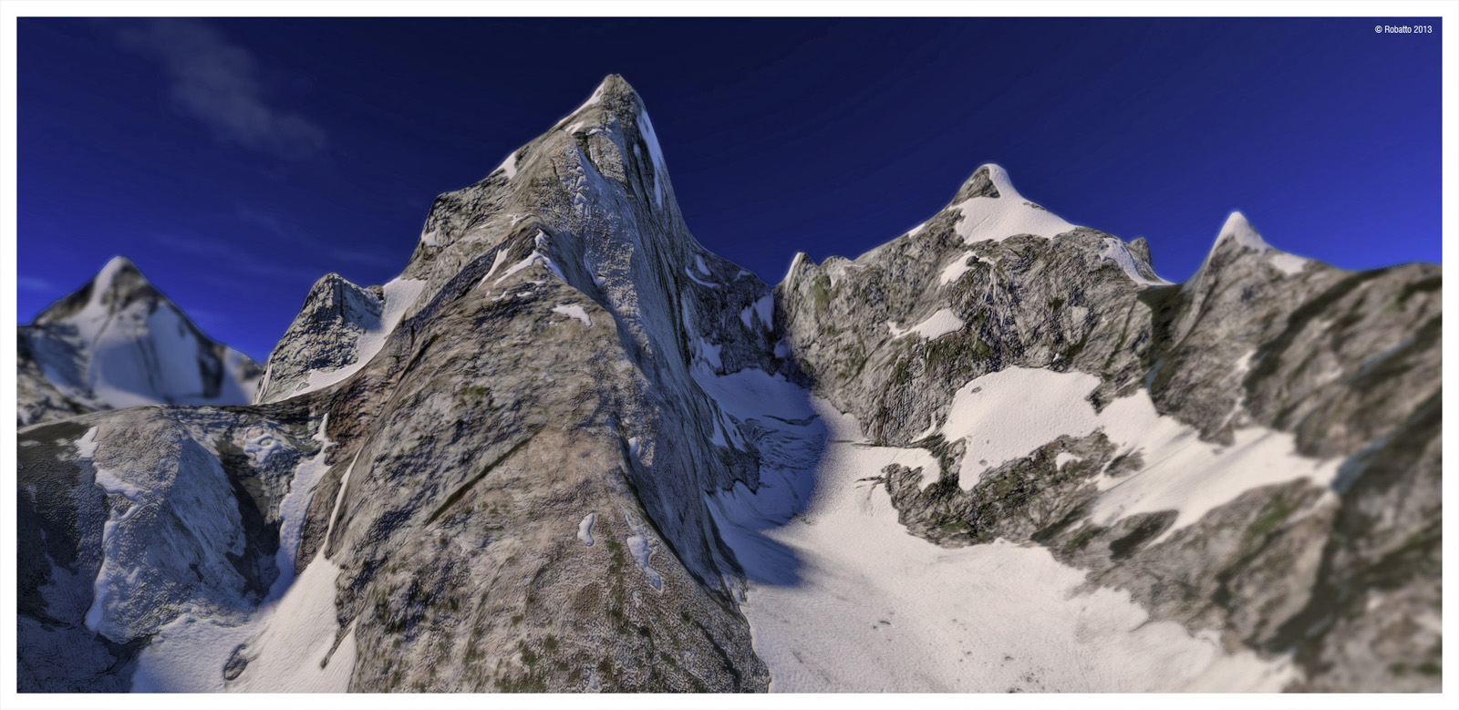
I ended up doing 3 versions. One covering a wide area and finally settling on this highly detailed model. The textures if from Bing maps which I stitched together after taking screen shots of areas. A painstaking process I suppose. This one is using approximate 1" = 100' zoom. I then touched up (clone stamped) areas to get rid of shadows. Created bump maps for rocky areas and glaciers. Rendering is using Kerkythea. Topo lines are 400' in elevation.
-
-
Winner
-
Wow, Gus:
Excellent work. You certainly put that plugin to work.
By the way, is that "ACME APEX" Premium Quality Duct Tape on that cord jack, or just your run of the mill quack tape?

-
Jaw drop! awesome, great plugin
-
-
Gus,
This is a impressive example and I am glad to see it seems to work.
And thanks for describing the whole process. In my first design, I assumed the starting point would be clean contours with elevations. Then I realized that a large part of the workflow was about cleansing the contours from the DWG import and I introduced the cleanser.
Now, I think I should maybe think about adding a tool to transform a flat contour map into an elevated contour set.Also, would you mind sending me the model of contours. On the picture, I see that you have some sharp slope breaks and flattish basins. Currently TopoShaper is based on linear interpolation, and the few trials I made for a more sophisticated interpolation to get more smoothing did not reveal productive (long calculation time and artefacts). But I could try again on your model.
Finally, if you don't mind, I'd like to refer to your thread about these beautiful Colorado mountains in the main post of TopoShaper to illustrate the possibilities of the plugin of less conventional terrains.
Thanks
Fredo
-
@unknownuser said:
Gus,
This is a impressive example and I am glad to see it seems to work.
And thanks for describing the whole process. In my first design, I assumed the starting point would be clean contours with elevations. Then I realized that a large part of the workflow was about cleansing the contours from the DWG import and I introduced the cleanser.
Now, I think I should maybe think about adding a tool to transform a flat contour map into an elevated contour set.Also, would you mind sending me the model of contours. On the picture, I see that you have some sharp slope breaks and flattish basins. Currently TopoShaper is based on linear interpolation, and the few trials I made for a more sophisticated interpolation to get more smoothing did not reveal productive (long calculation time and artefacts). But I could try again on your model.
Finally, if you don't mind, I'd like to refer to your thread about these beautiful Colorado mountains in the main post of TopoShaper to illustrate the possibilities of the plugin of less conventional terrains.
Thanks
Fredo
Thanks to everyone for the compliments.
Fredo, sure, you could use this as an example for your main post. I attached the topo here. The elevation intervals are 400 feet. The USGS map was based on 80 foot intervals at 5 each for a total of 400 feet for the thicker lines which was easier to create. That will result in some loss of details.
I was thinking about perhaps adding a feature where you could add a point for a sharp peak perhaps. Otherwise, increasing the grid to the max (anything close to 200) will result in sharper peaks. On the USGS maps the closest you'll get to a peak will be a small elliptical topo line at the top of the summit.
The Grand Tetons (Grand Teton National Park) are in Wyoming, just south of Yellowstone National Park. Other than that, great plugin. Another good thing about this plugin is that you can leave SU while it's processing and won't freeze up SU. Thanks!
 Correction. Here's the correct topo.
 -
@mitcorb said:
Wow, Gus:
Excellent work. You certainly put that plugin to work. By the way, is that "ACME APEX" Premium Quality Duct Tape on that cord jack, or just your run of the mill quack tape?
Thanks! Forgot to answer your question. That's just supposed to be a weathered metal plug casing. From my Stratocaster model.

I know you were kidding. Was just testing TopoShaper to see if it could do an arch top. Close.
-
@unknownuser said:
Gus,
... Now, I think I should maybe think about adding a tool to transform a flat contour map into an elevated contour set.mmmmmm ... that would be just the maximum

cheers
-
Wow! That is fantastic! If there were any bugs in that plugin, I am sure you found them out. Great job!
-
@unknownuser said:
Gus,
Now, I think I should maybe think about adding a tool to transform a flat contour map into an elevated contour set.
Fredo
If you manage that, you will be a GOD
Hello! It looks like you're interested in this conversation, but you don't have an account yet.
Getting fed up of having to scroll through the same posts each visit? When you register for an account, you'll always come back to exactly where you were before, and choose to be notified of new replies (either via email, or push notification). You'll also be able to save bookmarks and upvote posts to show your appreciation to other community members.
With your input, this post could be even better 💗
Register Login


Advertisement