[Plugin][$] TopoShaper - v2.7b - 30 Jan 26


-
@melresdes said:
Thank you. I tried to use the native sandbox tools but it locked up SketchUp. I will look into the Artisan plugin.
Did you build the terrain from iso-contours (so you get a quadmesh) or from a cloud of points (so you get a triangulated mesh)?
-
A problem with the native sandbox tool--don't pre-select the mesh. Vertex Tools ($) also helps for some work.
-
@pbacot said:
A problem with the native sandbox tool--don't pre-select the mesh. Vertex Tools ($) also helps for some work.
Thanks! That is what I was doing wrong. I appreciate the help.
-
Hi , I try to figure out how I can create a terrain from a 3D dwg file I'm given.
When you import this in SU and you keep the points and explode the components you see that Entity info confirms that they are Guide Points.
I select them all and try to use the Points cloud fonction of the plugin but it fails or crash my SU ( pro 2018 on Mac btw ).
I upload the dwg file if someone is kind enough to tell me what I'm doing wrong .
Thanks for the good job though , big fan of your work .
Thanks everybody
-
@rom1br said:
I select them all and try to use the Points cloud fonction of the plugin but it fails or crash my SU ( pro 2018 on Mac btw ).
Did you enclose all guide points within a group and then launch TopoShaper on this group?
-
NEW RELEASE: TopoShaper v2.5b - 11 Apr 19
Requirement: LibFredo6 8.7a
TopoShaper 2.5b includes another major fix for SU2019, preventing it to launch correctly .
Home Page of TopoShaper for information and Download.
-
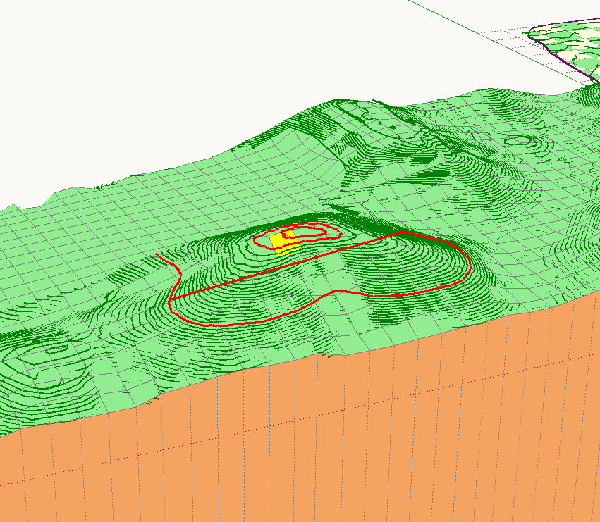
Working on a issue here. The main hill in my terrain is coming out deflated. In the screen shot, have selected "Show contours used by each node of the mesh". It looks like a lower contour is coming into play. (is this query relevant?) I have the hilltops set to "rounded". There is no straight line like is highlighted here connecting that contour below. No hidden lines. Maybe the contour file is too rough there are some gaps and big hole as you can see. At least I am reading the manual now.
I can see there is a point where I can see these erroneous closing of contours (the straight lines). At this point in cleansing I can ignore the contour or simplify it. I wonder what steps I should take a that point to correct the straight line connections.
-
I think I am really pushing it here. Two large a sample. Everything with this file is super slow. But it appears that I can find these troublesome contours and have TopoShaper ignore them--it doesn't hurt the outcome.I just seem to have quite a few of these contours trying to close from far away.
The bad contour did not show until after "Calculating Contours" I selected it and noted the elevation. Went back to "Cleansing"and right-click: exclude the contour from calculation of mesh(sorry I can't remember exactly what the contextual menu called it). I also just have to run smaller chunks of contours at a time.
-
-
I'll pm you, Fredo. Thanks!
-
Hi everyone. I'm came to this community to use the seemingly wonderful TopoShaper but nothing happens on my end... I followed the simple instructions and i get this lines in Ruby :
Error: #<Errno::ENOENT: No such file or directory @ rb_file_s_mtime - /Users/claire/Library/Application Support/.LIBFREDO6_DATA_Dir/LibFredo6_all_defaults.dat>
/users/claire/library/application support/sketchup 2019/sketchup/plugins/fredo6_!libfredo6/lib6registry.rbe:113:inmtime' /users/claire/library/application support/sketchup 2019/sketchup/plugins/fredo6_!libfredo6/lib6registry.rbe:113:inneed_reload?'
/users/claire/library/application support/sketchup 2019/sketchup/plugins/fredo6_!libfredo6/lib6registry.rbe:118:ininit' /users/claire/library/application support/sketchup 2019/sketchup/plugins/fredo6_!libfredo6/lib6registry.rbe:141:instore'
/users/claire/library/application support/sketchup 2019/sketchup/plugins/fredo6_!libfredo6/lib6plugin.rbe:1281:inusage_use' /users/claire/library/application support/sketchup 2019/sketchup/plugins/fredo6_!libfredo6/lib6plugin.rbe:1269:incommand_invoke'
/users/claire/library/application support/sketchup 2019/sketchup/plugins/fredo6_!libfredo6/lib6plugin.rbe:1252:inblock (2 levels) in build_config_commands' /users/claire/library/application support/sketchup 2019/sketchup/plugins/fredo6_!libfredo6/lib6traductor.rbe:1361:inblock in add_command'I'm not code savvy and im new to Point clouds too.
Can anyone offer assistance here?
I'm using Sketchup Pro 2019 on a MacBook Pro... -
Could you try with this version LibFredo6 8.9b.
It might come from your installation, but I made theis portion of the code more resilient.
Fredo
-
Thanks a lot!! Un gros merci @fredo6, ça marche

-
-
Non, c'était bien la première fois. J'ai supprimé les plugins installés dans l'Extension manager et j'ai installé le nouveau lien que tu as posté, fermé SU, réouvert, puis ensuite ré-installé TopoShaper. J'ai réussi à faire un mesh avec les points que j'avais!
-
So we have a solution ?
Nous avons donc une solution?
-
Thanks for Toposhaper - it is wonderful!!!
I'm using it on the last Google version of Sketchup (8), and have had no problems over a long period. I recently updated to v2.5b (and LibFredo v8.9b) and have not been able to complete the final build.
I would appreciate your suggestions - I know that SU 8 Pro is now very outdated, but it is a all I need!NOTE: The latest versions work fine on Sketchup Make 2015, but fail on the final stage with SU 8.
CLEANSING - no problems
PREVIEW - no problems
Choosing flat or rounded - no problems
Generate Terrain - Ruby error here is the log file.Date; 22-Jun-19 21;30;15 An error occurred in GENERATION OF TERRAIN The operation is fully aborted undefined method `hovering_notification' for #<Traductor;;Palette;0x1bd6e938> (eval); 102 -- onMouseMove (eval); 870 -- onMouseMove (eval); 865 -- onMouseMove_zero (eval); 1309 -- geometry_terminate (eval); 449 -- call (eval); 449 -- terminate_execution (eval); 332 -- next_step (eval); 2548 -- geometry_step_exec (eval); 2493 -- geometry_execute (eval); 370 -- call (eval); 370 -- step_geometry (eval); 419 -- start_execution (eval); 2493 -- geometry_execute (eval); 1280 -- geometry_execute (eval); 668 -- execute_validate (eval); 130 -- execute_from_palette (eval); 76 -- notify_from_palette (eval); 431 -- getMenu body_Lib6Tool.rb; 1478 -- call body_Lib6Tool.rb; 1478 -- show (eval); 102 -- call -
There must be something wrong in your installation of LibFredo6 and the problem you have is very strange, including the bug report.
Can you clean up LibFredo6 and reinstall.
Fredo
-
Thanks Fredo.
All working now.
Not sure what the problem was, but the Sketchucation Uninstall process did not fix it.
I had to completely remove LibFredo and Toposhaper including all directories from the Plugin Folder and reinstall using the Sketchucation Installer. I tried the Preferences installer first, but that was not successful.I dearly love Toposhaper!
Moz -
@mozzie said:
I had to completely remove LibFredo and Toposhaper including all directories from the Plugin Folder and reinstall using the Sketchucation Installer.
Glad it works. For a strange reason, you had a mix of old and new files in LibFredo6. Maybe this is the installation in SU8. Always make sure you overwrite the files.


Advertisement