[Plugin][$] TopoShaper - v2.7a - 01 Apr 24
-
Brief description what i did.
import dwg (mostly in one plane)
run toposhaperwhat i hoped for = have a surface generate over dwg lines with separate surfaces for different parts of dwg. Like street, lawns, pavements would be one surface with selectable areas.
-
I tried this and I got a flat surface with soften-smoothed triangulation--separate from the import.
This is not what toposhaper is developed for, but you could at that point "drape" the dwg lines onto it if you want with SandBox. Within the limitations of dwg import (often has problems) and the software (can't solve everything) you may get what you want.
I would recommend: 1. Remove all lines you really don't need in a terrain model before import. 2. Separate buildings and things that are not going to be molded with the terrain into groups before import and possibly group roads and landscape areas. 3. Clean up the dwg after you get it in. Intersections of curves for example will not be correct. You may wish to make faces in the dwg before going further.
Then use the Sandbox tools to make a terrain and drape the lines onto it. Alternately there are ways to just apply a terrain grid in specified areas like lawns. I'd try it with simpler shapes first. The whole dwg import may be too much for it.
My methodology would be to separate graded or sculpted terrain completely from buildings and most hardscape--merging or cutting only where it's useful.
-
thanks i will look into it.
-
good
-
 Very, very thank you. Fredo. You are the master!!!
 -
To anyone that can help and guide me on this.
Attached is a grading plan of a piece of land that I am working with. I imported this from a 2d dwg file. I made a group of the contours and when I run the plugin I can't get it to show any grade variations and there are some extra lines that show up in red.
I don't follow why some lines are green and others are not.
The large flat open area is where I am placing a building and parking lot.
Just not sure how to go about this.
This file is saved as V8 but I am working in 2013Pro.
Thanks,
Larry
-
cubcrafter - many of the lines have gaps in them (double click any line and normally you'd get the entire line; not the case with many of your lines) - get thee to http://www.smustard.com/script/StrayLines and you'll find a free tool to help you find them. Then you can join them manually by adding lines to the gaps, it's worth running this on any imported ACAD (or any dxf or dwg file) import.
OR this (US20.00) plugin helps you close them http://www.smustard.com/script/CloseOpens - well worth the money I'd say.
Here's a discussion on the issue http://sketchucation.com/forums/viewtopic.php?f=15&t=24427&p=211465&hilit=lines+joined+gaps#p211465
-
Is anyone else having the following problem with TopoShaper?...
When I click on my contour group, it goes into Cleansing mode, but the Cleansing dialogue box (across the top) is missing. It's just not there.
If I then Right-Click on the contours, and choose "Go to the Calculation and Preview of the Terrain", it runs the calculation and jumps into Preview mode, and the Preview dialogue box DOES show up.
Anyone know what's going on, or if there's a solution??
Thanks.
Dave.PS - I'm using SU 2013 on Windows 7
-
Follow up to my above Post.
This happens on ANY model.
I opened the Ruby Console, and ran it again. The Ruby Console kind of went nuts, and just started scrolling the following over and over, until I Right-Clicked and choose "Go to the Calculation and Preview of the Terrain". Then it stopped scrolling, and the script functioned normally.
Error: #<NoMethodError: undefined method
option_hilltop_possible_on_selected?' for nil:NilClass> C:/Program Files (x86)/SketchUp/SketchUp 2013/Plugins/TOPOSHAPER_Dir_10/TopoShaperTool.rb:1572:inpalette_floating_algo'
C:/Program Files (x86)/SketchUp/SketchUp 2013/Plugins/Fredo6_!LibFredo6/Lib6Palette.rb:1877:incall' C:/Program Files (x86)/SketchUp/SketchUp 2013/Plugins/Fredo6_!LibFredo6/Lib6Palette.rb:1877:inbutton_check_hidden?'
C:/Program Files (x86)/SketchUp/SketchUp 2013/Plugins/Fredo6_!LibFredo6/Lib6Palette.rb:1875:inbutton_check_hidden?' C:/Program Files (x86)/SketchUp/SketchUp 2013/Plugins/Fredo6_!LibFredo6/Lib6Palette.rb:1857:inbutton_track_changes'
C:/Program Files (x86)/SketchUp/SketchUp 2013/Plugins/Fredo6_!LibFredo6/Lib6Palette.rb:1157:incompute_multi' C:/Program Files (x86)/SketchUp/SketchUp 2013/Plugins/Fredo6_!LibFredo6/Lib6Palette.rb:1150:ineach'
C:/Program Files (x86)/SketchUp/SketchUp 2013/Plugins/Fredo6_!LibFredo6/Lib6Palette.rb:1150:incompute_multi' C:/Program Files (x86)/SketchUp/SketchUp 2013/Plugins/Fredo6_!LibFredo6/Lib6Palette.rb:1128:incompute_button'
C:/Program Files (x86)/SketchUp/SketchUp 2013/Plugins/Fredo6_!LibFredo6/Lib6Palette.rb:1229:incompute_all' C:/Program Files (x86)/SketchUp/SketchUp 2013/Plugins/Fredo6_!LibFredo6/Lib6Palette.rb:1229:ineach'
C:/Program Files (x86)/SketchUp/SketchUp 2013/Plugins/Fredo6_!LibFredo6/Lib6Palette.rb:1229:incompute_all' C:/Program Files (x86)/SketchUp/SketchUp 2013/Plugins/Fredo6_!LibFredo6/Lib6Palette.rb:1975:inlist_visible'
C:/Program Files (x86)/SketchUp/SketchUp 2013/Plugins/Fredo6_!LibFredo6/Lib6Palette.rb:1988:inlocate_button' C:/Program Files (x86)/SketchUp/SketchUp 2013/Plugins/Fredo6_!LibFredo6/Lib6Palette.rb:2048:inonMouseMove'
C:/Program Files (x86)/SketchUp/SketchUp 2013/Plugins/Fredo6_!LibFredo6/Lib6Palette.rb:2302:inonMouseMove' C:/Program Files (x86)/SketchUp/SketchUp 2013/Plugins/TOPOSHAPER_Dir_10/TopoShaperTool.rb:813:inonMouseMove'
C:/Program Files (x86)/SketchUp/SketchUp 2013/Plugins/TOPOSHAPER_Dir_10/TopoShaperTool.rb:1572Any ideas on what's happening??
-
Not sure what it is.
Could you re-upgrade to the latest version......or wait a little bit (Tomorrow) as I will publish a new version which includes an Altitude Editor.
Fredo
-
NEW RELEASE: TopoShaper v1.1a - 07 Nov 13
This is a major release with the following evolutions:
- Interactive Altitude Editor
- Back Map, i.e. picture that can load and adjust to the contour map. This can be useful with high-resolution image for altitude edition
- Generation of contour map with Altitude labels
These features are illustrated on the video below
[flash=640,480:38uicv2k]http://www.youtube.com/v/-n6kL6YcTtA&hl[/flash:38uicv2k]
See main post of this thread for Download.
Fredo
-
Schweeeet!

-
this is quite an incredible tool... goodbye drape.
-
Great! Fredo. But I have a question. How to change the Altitude Editor's units?
-
@arc said:
Great! Fredo. But I have a question. How to change the Altitude Editor's units?
Units are those of the model.
So just change the model units.Note: in dialog boxes, you can enter value with any unit, for instance '45m', even if the model units are not meters
Freedo
-
Dear Fredo,
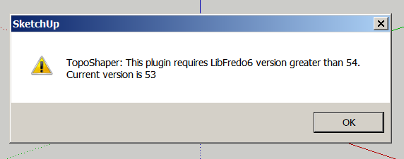
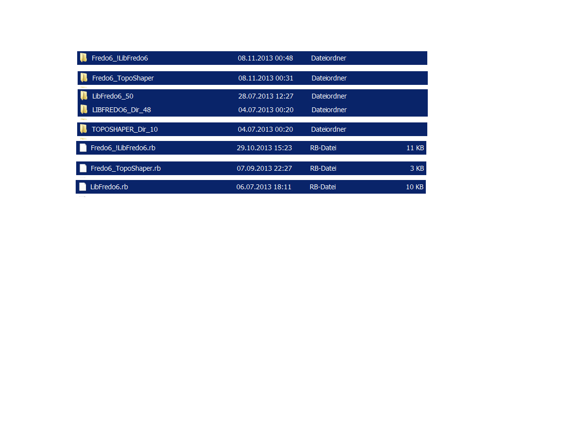
After the installation, now get this error message. After I've seen in the plugins directory I am now very confused. I do not know what I must do. I also tried the Fredo6_ LibFredo6 - v5.4a - 13.rbz November 7 to install but without success.


-
Fredo,
Amazing plugin.
Your plugins really help my work flow go smoother.
Thank you,
erikB -
@Karlheinz...
Are your Plugins folder's permissions set to FULL ?
Have you definitely installed the latest version of the Lib from the Plugin Store..
AND the new Top toolset ?
Get the RBZ versions and compare the contents ...Then restart SketchUp.
If you get error messages thereafter, then report back

-
@charly2008 said:
Dear Fredo,
After the installation, now get this error message. After I've seen in the plugins directory I am now very confused. I do not know what I must do. I also tried the Fredo6_ LibFredo6 - v5.4a - 13.rbz November 7 to install but without success.
You should delete the Libfredo files and folders which do not begin with Fredo6_...
-
Thanks Tig, thanks Cotty,
the deletion of the mentioned files solved the Problem.
Charly
Advertisement


