Stereoscopic 3D Walkthrough using Sketchup
-
I noticed some discussion on stereoscopic 3D images at http://forums.sketchucation.com/viewtopic.php?f=15&t=16501
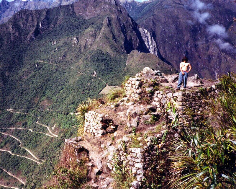
I recently completed an accurate Sketchup replica of the ancient Inca city of Machu Picchu which I will be uploading to the 3D Warehouse shortly. Part of it (Wayna Picchu) has already been uploaded. I created a video of the entire model to demonstrate it here: http://www.youtube.com/watch?v=YI6M9LC4Pn0
I then noticed that YouTube now has full support for stereoscopic videos so I decided to try to make a stereo version of the video using Sketchup. It proved very simple. Here is the result: http://www.youtube.com/watch?v=68DHzxjnqL8
-

Really great model and presentation (of course, if you could take photos of all the actual structures and use those as textures, it could be even more spectacular!)I need those stereoscopic glasses.
-
Hi pmolsen,
I find your model so spectacular and I'm fascinated by models in a terrain. I would also like to do something like that. But mostly it failed because i couldn't find good plans or maps. Wayna Picchu, I have now seen the first time. It can not be seen at GE.
How long have you worked on it and what resources did you use as a basis? I would be delighted if you would describe a little bit your workflow for this model.
Karlheinz
-
Gaieus,
I have photos of most of the structures and started using them as textures, but it soon became apparent that the resultant model size would be enormous. What I have used is an actual photo of part of one wall.
Apart from a few buildings, in particular those that I did texture differently, the stonework is remarkably similar. Once the textures are down-sized by Google it would be very difficult to tell one from the other.
Karl, I have been working on the model for 18 months. It was a much bigger exercise than I anticipated. I used a laser scan of the site done by the University of Arkansas which produced a point cloud file of 80M points. It took a measurement every 3cm. The actual files I used were stripped down ones with about 20M points in total.
I expected to be able to just triangulate the points and import them, but it proved impossible due to the size. There is a cloud.rb plugin that can import the point cloud as construction points but it causes Sketchup to grind to a halt with just a few thousand points.
To start with I tried cutting the data into hundreds of pieces and triangulating and importing it. It worked fine but it proved to be a pointless exercise. The resultant data, even when simplified, was massive. Had I used it the model would have been something like half a Gb in size.
I set myself a goal of 5Mb as a maximum file size. The model came in at almost exactly that, plus another 600k for the high-res terrain texture. That doesn't include Wayna Picchu, which is a separate model.
Trying to draw flat surfaces on the imported wavy surfaces was virtually impossible, partly because of inference snapping. There were so many lines and vertices nearby that it was impossible to draw a line where you wanted, hence my recent request for an enhancement to allow ALT or something to be pressed to override inference snapping..
In the end I used a program (Rapidform Explorer) that could produce a visualisation of the point cloud. I took multiple plan view screen shots then imported them one at a time into Sketchup as images and positioned and sized them accurately. The program also allows you to measure individual points so I printed off dozens of screen shots of the plan view then measured individually every significant point on the entire site and wrote the measurements on the plans.
I then drew all the structures on the flat plan view in Sketchup and then used the Pull tool to pull them up to the correct height.
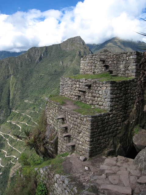
The big problem was that there were numerous structures, terraces, walkways, staircases etc that were missing from the scan. Places where the laser, positioned up to half a km away, simply could not see. For those I had to scour the web for photos - Flickr.com mainly, searching for photos that showed the particular area. For some of them, such as the remote lower terraces, that was quite a task.
For Wayna Picchu (Huayna Picchu) I could not find any good contour maps. I therefore imported photos from various angles, positioned them in the correct place and traced around the mountain outline. I then manually drew connecting lines and pulled them into shape.
I also had a laser scan of Wayna Picchu. That allowed me to do many of the structures and terraces although again it was missing a lot of detail. For the parts of the mountain itself that were in the scan I drew numerous vertical lines of the correct height then connected up all the top tips of the lines into triangles.
(TO get to the top of Wayna Picchu you have to crawl through a narrow cave. You will notice that the cave is also modelled.)
One interesting thing my photo searching showed up was the amount of restoration that has been done. Sometimes it had me very confused until I realised the photos were of the same thing. I have attached two photos of the exact same 3 terraces on Wayna Picchu that demonstrate it.
I did allow myself one concession to simplify construction. The walls of all buildings and terraces slope inwards slightly. I made them all vertical. They remain within 20-30cm of correct both at the top and the bottom. The only exception was the Temple of the Sun, which I drew with the sloping walls. Many terraces also have a slight slope. Where the ends were within about 30cm of each other I made them horizontal. Any more than that and I sloped them correctly.
Out of interest, what is wrong with the input screen on this forum? When I go beyond what will fit in the small window it keeps scrolling up and hiding what I am trying to type???
-
great model and animation. is it necessary some kind of special equipment to watch the 3D movie? my experience of it was dismal, as it was narrow on the screen. i enjoyed seeing the sketchup animation much more.
-
Hi pmolsen,
Thanks for the interesting explanation of your workflow. I have already suggested that it was a very time consuming and hard work.
But the result is wonderful. I wouldn't have this patient,18 months working on such a project.
Karlheinz
-
I cropped the 3D scene because otherwise when viewed in side-by-side mode the video is only half the height and the detail is too small.
There are many different techniques for viewing the stereoscopic images. YouTube caters for most of them. If you do not have special glasses then the easiest is to use the cross-eyed method. Takes a bit of practice. You must have your eyes perfectly horizontal otherwise the two images will not merge into one. Once they do the 3D image will be seen to float between the other two. (Basically the image for the left eye is on the right and vice versa.
The parallel method is easier on the eyes (the image for the left eye is on the left) but it cannot be used if the matching parts of the two images are further apart than the eyes. You can change your screen resolution to achieve that but the result is a tiny image.
I really only created the video as an exercise in the use of Sketchup. I agree that the normal video is more interesting. Of course once all PC's have support for circular polarisation or similar, like Avatar, then it will be much more worthwhile.
-
Just a comment:
Google earth non pro just smears the city over the mountain-- no terracing effect. It is at the upper end of that squiggly trail up the mountainside. -
Not sure what you mean. Are you referring to the standard GE terrain? If so then yes, it shows nothing. Half the city is actually falling off the side of the mountain. The 3D model has been all but completed but not yet uploaded to the 3D warehouse. Only Wayna Picchu at this stage.
-
Machu Picchu model has now been uploaded to the 3D warehouse. http://sketchup.google.com/3dwarehouse/details?mid=736735667eaa157548846c67671d9660
-
I viewed the models of Machu and Huayna. Google must have reduced the resolution of the 2d/3d display image. However, looked interesting. Would love it if they decide to plop it into the 3d bldgs layer.
On behalf of the rest of the world, thank you pmolsen, if I may be so bold.
mitcorb -
Machu Picchu model has now been accepted to the 3D layer. Should appear shortly.
-
Now that's really good news, congrats!
-
That was amazing work
-
Wow, I thought I spent a lot of time on a model! What inspired you to undertake this huge task? I mean, why did you choose this site, is it special for you for some reason? Also, noticed there was only one tree, in a central location. Did this tree hold some sort of religious significance?
Just incredible work
-
Magnificent model of ancient Inca city, and cheers for dedicated effort to create it! Having hiked there in '83, your model exposes much more than what we could see at that time. The mountainous terrain is so much a part of Macchu Picchu that it really adds to the SU complexity and challenge.
Hello! It looks like you're interested in this conversation, but you don't have an account yet.
Getting fed up of having to scroll through the same posts each visit? When you register for an account, you'll always come back to exactly where you were before, and choose to be notified of new replies (either via email, or push notification). You'll also be able to save bookmarks and upvote posts to show your appreciation to other community members.
With your input, this post could be even better 💗
Register Login


Advertisement