Survey plans - developing a mesh from an imported PDF
-
Hi guys, I am often sent a PDF of a survey plan if a 3D file is not available. SO what I do is go about my work tracing contours loosely, moving each up in elevation then running the sandbox tool to create the terrain.
What I'm wanting to do rather than that is add Cpoints to each survey mark [which is always visible] at their true elevation then utilize TIG's 'triangulate points' plugin to pull them into a mesh.
My questions are:
-
is there a plugin to add a Cpoint that prompts you to add the Z height? [I guess you could draw a Cline with Cpoints vertically at each point on the PDF then clean up after...]
-
Once triangulated, how best do you 'soften' the mesh?
From there I think running one of a number of Contour plugins would produce me a better outcome...
Look forward to hearing from you guys.

-
-
I don't know of any surveyor that doesn't use ACAD. Just request the acad file and import it directly into SU. Typcially you will get all the line work set at z axis 0 and all the contours come in at their specified elevation. Then it is a simple matter of selecting the contours, use the sandbox tools to create the mesh, then select all the line work and use the drape tool to set on the ground plane you created with the contours.
This is the process I use, and I can typically model a 1-2 acre site in a couple hours, including trees.
-
I was hoping you'd get method here or some info from the more "civil"-minded among us. But perhaps I have something add.
I wonder if mesh so created would actually be as good as a civil engineer or surveyor creates on their system. If you can't get the 3d file from them, the contours they have shown on the plan might actually be better than using the field data in SU.
If I were doing that--tracing the file by hand, I would probably do it in CAD, where I have better tools for drawing and placing the contours at proper height.
As far as smoothing, I have used Artisan some for this, but I am trying Valiarchitects Instant Terrain to give a more regular mesh to the Sandbox results. It works pretty well, but it will take a couple projects to see if it helps. I think it will be a better mesh for use with Artisan sculpt tools.
-
@unknownuser said:
I don't know of any surveyor that doesn't use ACAD. Just request the acad file and import it directly into SU. Typcially you will get all the line work set at z axis 0 and all the contours come in at their specified elevation. Then it is a simple matter of selecting the contours, use the sandbox tools to create the mesh, then select all the line work and use the drape tool to set on the ground plane you created with the contours.
This is the process I use, and I can typically model a 1-2 acre site in a couple hours, including trees.
You're right Nick, I don't know of any surveyors that don't use ACAD either but sometimes I get given a PDF copy from a client and I have to find a work around. That's why I was thinking that creating an elevation point in SU at the survey elevation points on the PDF would suffice.
Sam [sdmitch] PM'd me a copy of his cloud maker plugin which pretty much answers my first question but softening the triangulated mesh is what I need to do now..... something like a polyreduce in reverse...
Cheers for your input.
-
@pbacot said:
I was hoping you'd get method here or some info from the more "civil"-minded among us. But perhaps I have something add.
I wonder if mesh so created would actually be as good as a civil engineer or surveyor creates on their system. If you can't get the 3d file from them, the contours they have shown on the plan might actually be better than using the field data in SU.
If I were doing that--tracing the file by hand, I would probably do it in CAD, where I have better tools for drawing and placing the contours at proper height.
As far as smoothing, I have used Artisan some for this, but I am trying Valiarchitects Instant Terrain to give a more regular mesh to the Sandbox results. It works pretty well, but it will take a couple projects to see if it helps. I think it will be a better mesh for use with Artisan sculpt tools.
Thanks Peter, I have traced but hand the contours but it can be laborious!!! Generally I just want to recreate the terrain for my own SU purpose; not for further use on site so I would leave the actual civil works to the professional!
I'll have to have a look at instant terrain; not sure how Atrisan work work though.
Cheers,
-
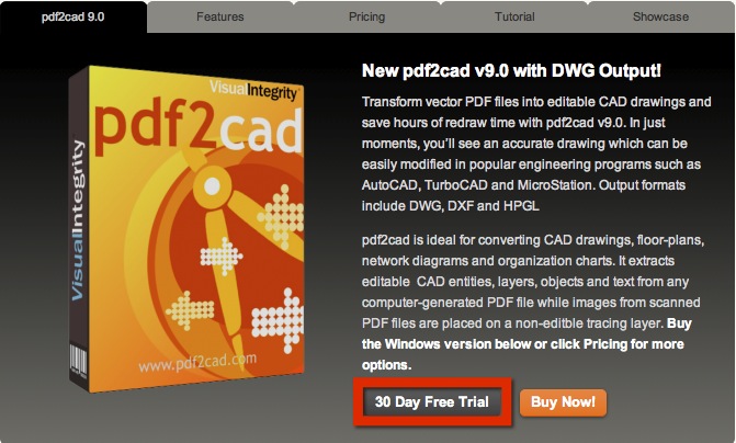
Andrew, just a shot in the dark. Have you thought about running the PDF through PDF2CAD? I am testing the latest version at the moment and find that it sometimes produces entities at different level. If you like, email / PM the file to me and I will see how it works with it.
Mike
-
-
From a liability stand point, I would always try to use only the information the surveyor provides. Sand box tools do an excellent job of creating the mesh from contours, without you having to interpret or "guess". It is also really fast.
I'm sure most if not all surveyors would be willing to send you a digital file. I've never had an issue with that, and I work with about 6 different surveyors.
I currently have a 3500 sf home under construction on a really steep lot (30% slope). The design has lots of tiered patios and elevation changes that relate to the topography. We had no issues in the field.
Another aspect of utilizing the contours provided by the surveyor is that it makes pinning building corners very quick and easy using the measure tool.
Since the sandbox tool is creating the mesh from the contours, those lines by default appear in teh mesh when you select "show hidden geometry". This really makes a difference when setting a project at a particular elevation relative to the survey.
Mike that looks like a great piece of software, but I doubt it can extrapolate Z vector information, which is what you would need for the contour information.
-
This is the project I mentioned above.


-
@mike lucey said:
Andrew, just a shot in the dark. Have you thought about running the PDF through PDF2CAD? I am testing the latest version at the moment and find that it sometimes produces entities at different level. If you like, email / PM the file to me and I will see how it works with it.
Mike
Yeah, but not this program, Mike. Can't recall what one it was but I did trial a piece of software last year...
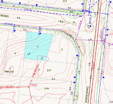
Thanks again for the input, Nick. I do understand your viewpoint but maybe this image might give you an idea of another need for extracting elevation data from an image / PDF.
I opened it in GIMP, saved to jpeg then imported it into SU and scaled it to suit. I then went about drawing bezier curves around each contour [very time consuming as well as fiddly as you have to make sure that the length of each contour has roughly the same segment lengths...] to an extend around the site that is necessary.
While in GIMP, I even tried selecting contours by color, creating a new layer then somehow converting to vector via inkscape but the image size is always an issue.Anyway, I hope this explains a little more about how we could work around terrain modelling for general use rather than build specific.
-
If you can get the acad file, you could create that topography for that site with sandbox tools in minutes. Am I missing something?
-
You're not missing anything, Nick. If the DWG is not available or in this case the PDF has come from the local council from the geo-cadastal program I'll just wanting to explore a work around.
Yes, given a DWG file of contours would take no time whatsoever... -
TGI3D has some clever mesh creation tools that can tessellate skins and all sorts of trickery.
If you can share a section you want smoothed it would help
Sent from my iPad
-
Some pdf files are actually vector based and the Mac version of SU can import them űas such (no need to retrace them?). I understand that you are omn Windows however...
As for softening or makingb the mesh more "regular looking", you can use Fredo's Terrain reshaper. It has features like defining final quad/tri density (i.e. downsampling a too dense mesh) etc.
-
He's uploaded the pdf in question. Its a raster pdf.
If you have a better/cleaner raster you can also use illustrator or any other vector software to trace the line work for you. Its never simple nor perfect, sometimes can be helpful.
-
I'd hire the local thugs and shake that DWG out of the surveyor!
Now I understand - you can't get the DWG for some reason, or it was created on something other than ACAD. I've never run into this yet.
-
@rich o brien said:
TGI3D has some clever mesh creation tools that can tessellate skins and all sorts of trickery.
If you can share a section you want smoothed it would help
.
About this much, ma wee lad....
-
@mike lucey said:
.... or you could try it yourself as there's a 30 day trial.
Pretty similar to Bluebeam, Mike. Although I think BB looks a better all round package...
http://www.bluebeam.com/us/products/revu/Andrew
-
@unknownuser said:
I'd hire the local thugs and shake that DWG out of the surveyor!
Now I understand - you can't get the DWG for some reason, or it was created on something other than ACAD. I've never run into this yet.
 For some reason, Nick I do! I'd much rather have sent to me a nice clean survey DWG but no, the client always expects you to create a little magic!
Hello! It looks like you're interested in this conversation, but you don't have an account yet.
Getting fed up of having to scroll through the same posts each visit? When you register for an account, you'll always come back to exactly where you were before, and choose to be notified of new replies (either via email, or push notification). You'll also be able to save bookmarks and upvote posts to show your appreciation to other community members.
With your input, this post could be even better 💗
Register Login


Advertisement