Photo merge... HELP!!!
-
Hey guys, I'm really struggling here... I've got this job where I've modelled what needs to be modelled and now I've been given some hi-res aerials that I can't get to match...
Here's the pics [low-res]
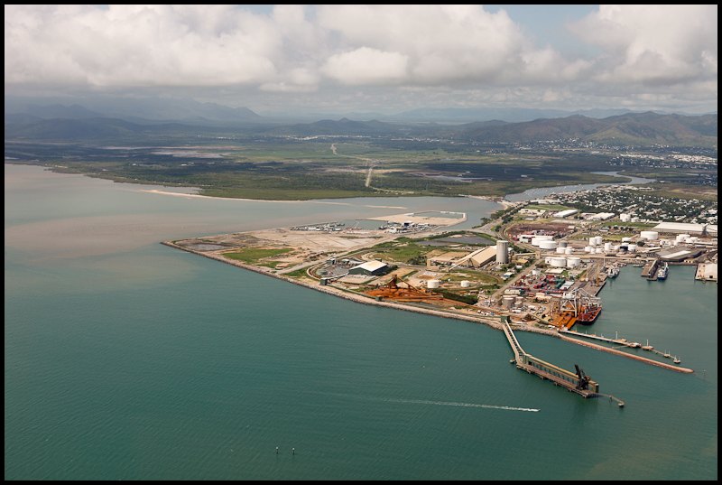
And an image of the model over a GIS aerial..... [too large to post...]
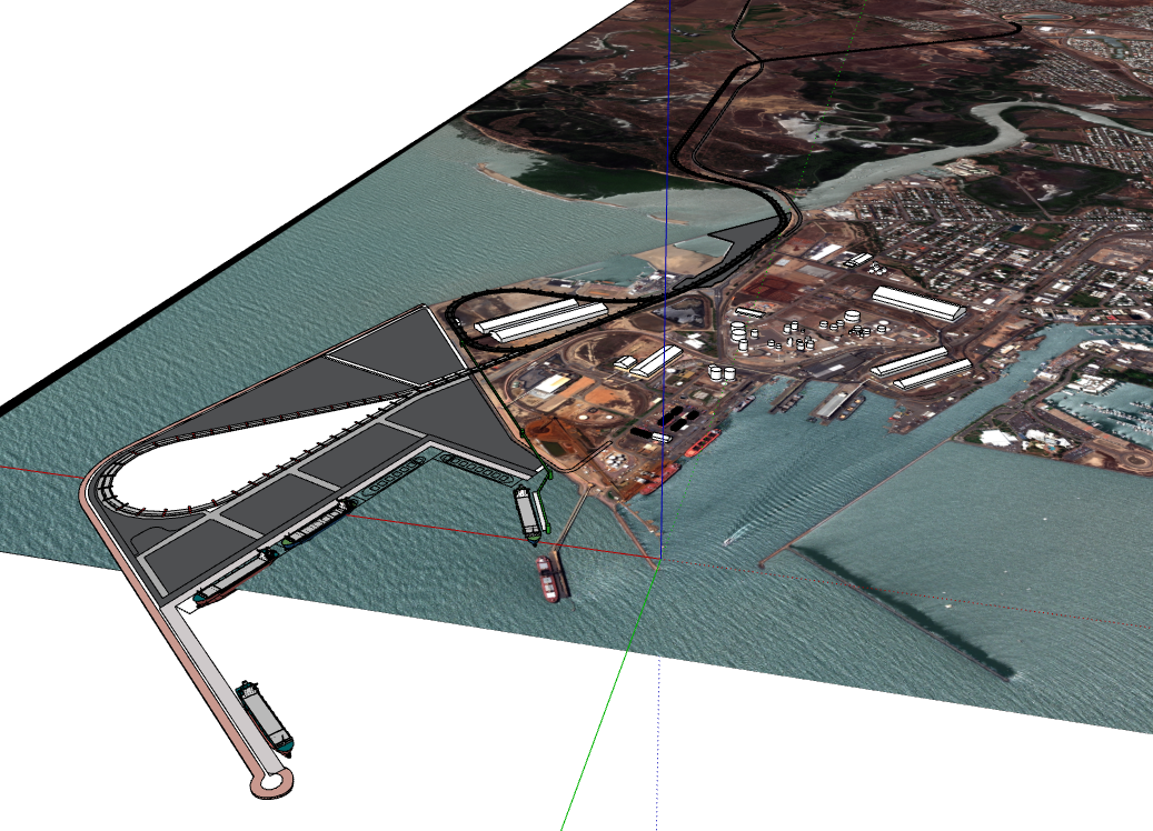
Cheer guys, thanks in advance... -
http://cs.bath.ac.uk/brown/autostitch/autostitch.html ?
But I am not sure to understand the problem

You don't find some images for extend the previous ones
or you don't know how merge some images at different scale/resolution
or...? -
andrew,
there should be at least two images to match. I am assuming you want to merge two or more partial images into a comprehensible one.
-
Sorry for the confusion, guys.

As you can see by he second image, i have modelled an expansion to a shipping port by way of importing an aerial photograph and scaled it to suit just as you would with any plan import.
What I need to do now is take that model and photo-match it; show the proposed expansion in context with the photograph taken from a helicopter..... I'm finding it difficult as the photographer has taken the picture at 63mm zoom but:
- I don't know how that relates to SU's FOV toggle as it is in degrees (I think)
- Photo-match is not a good start as the photo is too complex for it!
I'm stumped.

-
The fov doesn't really matter when it comes to matching the model to the image.
What matters, and what changes the perspective, is the position of the camera relative to the model.
You could always zoom in/out to make it fit once you have the camera positioned/rotated correctly. -
Well it should seeing each photo is generally taken with a different FOV.... Believe me, when i try to match the photo with the model it becomes severely distorted!!
-
- I don't know how that relates to SU's FOV toggle as it is in degrees (I think)
Tool Zoom : "xx.deg." inside the VCB page right bottom
here maybe 40 ° ? -
Have you tried going to google earth and grabbing vertical views to set up your base model?
-
Import the photo as a foreground watermark in SU and make it transparent then rotate and zomm your model to match!
-
Tgi3d photoscan may be of some help here especially if you have more than one aerial photos. Learning Tgi3d can take some time, but in a pinch I can try calibrating the aerials if you somehow (post/pm/dropbox) send them to me. To get the object scale right I would need correct distance between two visible features or coordinates of some visible features. Once you have a calibrated photomatch scene you need to rotate/translate your built model to match the existing features.
Ogan -
Photomerge is not the good tool for your project. It works fine on orthogonal objects.
For your problem, I will use the coastal navigation way to locate a point. We use alignments of land object like towers or mountains. In your aerial view, we can also use planar object like roads or river.- First search "vertical" alignments in the aerial view
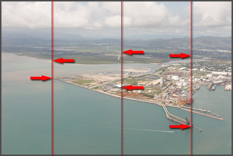
- Next, report alignments on the SU model. They would intersect in a point (or nearly)
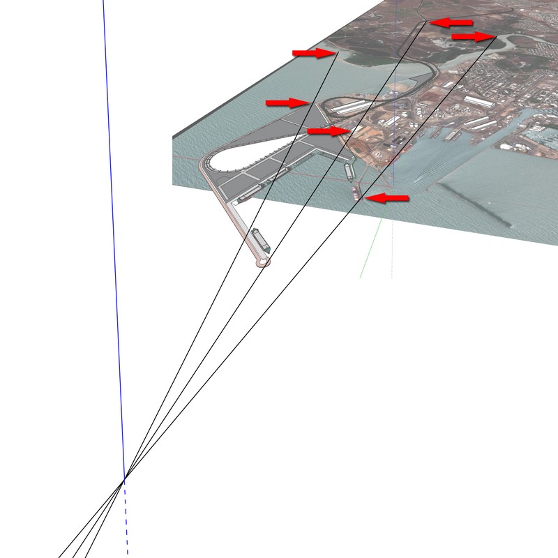
- Finally, the point of view would be on a vertical line over this intersection. Turn off the background model and place the aerial photo on background in the style setup panel.
Use the "place camera" tool on the intersection and use the Value Control Box to enter and test altitude and the Look Around tool too find the good direction and type angle of view in the VCB with the Zoom tool activated to find the right field of view. Don't use zoom tool directly on the model because it change the camera position (is not a real "zoom" tool, it's a "walk ahead" tool !).
If you have some data about the aerial photo (altitude, angle of view...), that will help you to find the right place and view.
Hope that can help you.
- First search "vertical" alignments in the aerial view
-
@utiler said:
Well it should seeing each photo is generally taken with a different FOV.... Believe me, when i try to match the photo with the model it becomes severely distorted!!
That's because when using zoomm in Su it isn't really zoom, but moving the camera, which changes the perspective. Change the FOV to "scale" it, and the zoom to change perspective/position.Edit: That technique posted by @daredevil is a very good one
 I often use a similar one, but haven't actually drawn those lines. Next time I will
Using the Walk tool (or Look-Around) you can type in the eye altitude, or use the mouse+shift to change it.
-
Daredevil!


-
Cheers guys!! Gee some neat ideas there....!
Here's where I got to with it:
- Imported hi-res watermark image into the model
- Fiddled with FOV settings to manipulate the model and WHA-LA!!
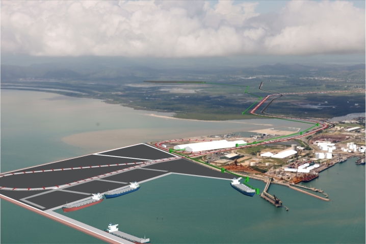
That is a good process, daredevil!!
 to you all; legends!!
 -
Wha-La?
Surely voilà

-
Only problem with bringing in a hi-res image as a watermark is that the export is only as good as SU exports your viewport... not good if you want to maintain pixel size.

-
Do the merge in Photoshop post pro mate!
-
I tried that but the problem is exporting a high enough image from SU.... When I exported and got rid of the background the edges were way too pixelated....
-
Drag it into layout with no background, convert to vector export hi res PNG from there!
-
Thanks smart-arse...... I'll try that!!

Advertisement


