[Plugin] Coords Text Tag from Datum
-
@ubi904 said:
It's a great plugin ,
 the only one problem is, that the user have to select manualy all the points and mark them, and only these, manually marked points will be exported, so a complet surface or more surfece's can not be exported to other program, which needs txt file as input (Surfer, Vertical Mapper etc.)
As I see, it has some limitations, even I can click on many point's, so I get a lot of points marked, above "X" point it can not be export to CSV, it make's nothing, the csv file will not be generated.
-
@gaieus said:
...(Or a simple vertex export - like a reverse Cloud.rb á la Didier?)
An export_vertices ruby is quite straight forward - I'll make you one...

-

-
It's here http://forums.sketchucation.com/viewtopic.php?p=298614#p298614
exportvertices2csv.rb ............. -
Hello TIG,
I’m working with Coords Text Tag from Datum v1.6 20101120
Gaieus suggested the plugin as a means of creating guide points at specified locations in a geo-located model using Latitude and Longitude as input data via ‘Add Coord by Dialog’.
The plugin works as expected with length units ... inches, feet, meters and so on.
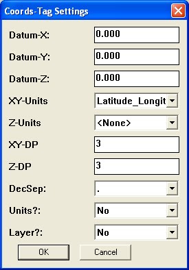
However, entering LL data via ‘Add Coord by Dialog’ yields odd results.These are the settings:
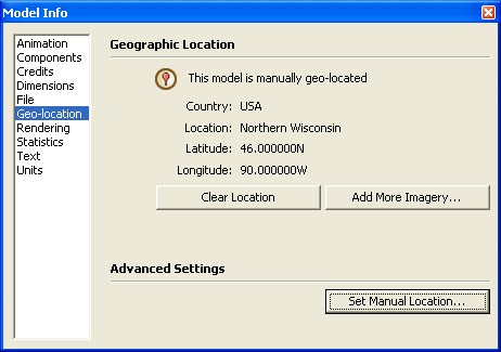
This is the location of the model:
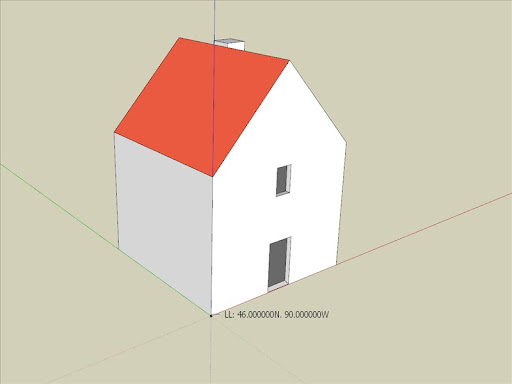
When I click the Add Coords-Tag tool on the Origin, the coord-tag is correct:
Then I try entering the exact model location in ‘Add Coord by Dialog’:
The result is consistently a coord-tag with Latitude way off to the south, near the Equator:
I tried unloading all plugins and the extensions in the Preferences-Extensions panel so this was the only plugin loaded when SU starts.
The results were the same.I'm at a loss to figure out what's wrong.
Am I entering the data improperly?Thanks,
-Geo
-
I just tried exactly what you did and it worked fine for me ???
Try with LL+Z ?
Can you post your exact steps to get to the problem............... -
Hello TIG,
Here’s what I’m doing, step by step.
-
Open a new SU8 Pro file.
-
Click … Window > Model Info > Geolocation > Set Manual Location
-
2x click the cursor in the Latitude field and then type 46.0N
-
2x click the cursor in the Longitude field and then type 90.0W
-
2x click the cursor in the Location field and then type Northern Wisconsin
-
Click … OK to close the Set Manual Geo-Location dialog box
The Model Info-Geo-location panel then appears like this:
-
Select and delete Susan
-
Click … Window > Model Info > Statistics > Purge Unused
-
Click … Window > Components and place the Simple House component at the *origin.
*Drawing Axes are confirmed to be in default position. -
Click … File > Save, type in the name, Test Model 1, and then click Save
The Save as Type: field is set to save as the current version, SketchUp Models (*.skp) -
In the Model Info-Units panel:
Length Units are set to decimal inches at 0.000” precision
Enable Length Snapping is OFF.
Display Units Format is ON.
Enable Angle Snapping is ON at 15° and Precision at 0.0° -
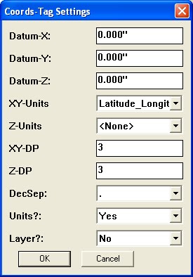
Click … Plugins > Coords-Tag > Settings, then Add
The Select tool cursor becomes a white arrow.
Set XY-Units to Latitude_Longitude
Set Z-Units to <None> (I tried all the other settings for Z as well, without success.)
Set Units?: to Yes
All other settings remain untouched.
The Coords-Tag Settings dialog now looks like this:
-
Click … OK to close the Coords-Tag Settings dialog box
The cursor returns to being the Select tool. -
Click … Plugins > Coords-Tag > Add Coords-Tag by Dialog
Nothing happens.
The dialog does not appear.
The Cursor remains the Select tool. -
Click … Plugins > Coords-Tag > Add Coords-Tag
The cursor becomes a white arrow tool.
It offers no inferencing dots or tool tips while hovering over the origin or endpoints.
L-Clicking or R-Clicking on geometry or on the ground plane does nothing.
All the tools work perfectly if I return to the Coords-Tag Settings dialog box and set XY-Units to ANY other unit besides Latitude_Longitude.
If I create a few tags with the XY-Units set to Feet or Meters and then return to the Coords-Tag Settings dialog and change XY-Units to Latitude_Longitude, the existing tags convert correctly to L. Lo. coordinates, after which, the tool remains active. I’m then able to inference and a L-click places another LL Tag and another and another.
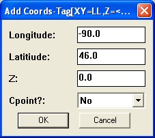
With the LL tags thus functioning, I then go to Plugins > Coords-Tag > Add Coords-Tag by Dialog and enter the model coordinates, L 46N Lo 90E
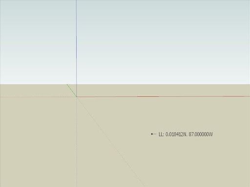
Like so:The LL tag appears at L 0.018N Lo 87.000W
No matter what I try, it returns the same value every time.Sorry this is so long.
Does my opus give you some clue as to what the problem is?Thanks,
-Geo
-
-
Thanks for the detailed response!
Can you try the last few steps with the Ruby Console open... Any errors ?
When I repeat the steps I get a good result
EDIT:
Having thought about it...
You must set the X/Y values as your long/lat values in the main dialog OR you can initially use NOT use long/lat but say meters and place one Tag at the origin... THEN change to Long/Lat and it should work... as the one at the origin changes to your Model's long/lat...
I'll have another think about this 'logic'... -
Hello TIG,
I opened 'Test Model 1' and did the following:
Window > Ruby Console
Plugins > Coords-Tag > Settings, then AddThe Settings, then Add dialog was as I last left it.
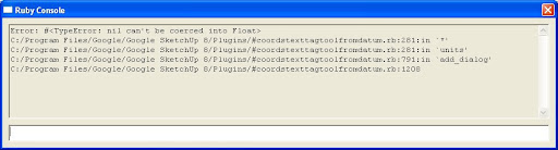
Like this:When I click OK to close the Settings, then Add dialog:
This error appears in the Ruby Console
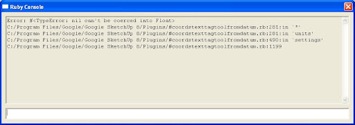
If I then click … Plugins > Coords-Tag > Add Coords-Tag:
This error appears in the Ruby Console
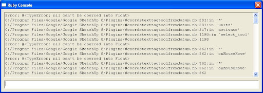
I close the model without saving changes and then reopen the model.
Window > Ruby Console
Plugins > Coords-Tag > Add Coords-Tag by DialogThis error appears in the Ruby Console
I hope this helps.
-Geo
Btw, this all started with a discussion in the SketchUp Help forum.
http://www.google.com/support/forum/p/sketchup/thread?tid=11ef233d3545c5f0&hl=enThe ability to create Cpoints directly from L. Lo. coordinates is a most welcome asset.
Thank you, TIG
-
By PM I've asked Gaieus to step in and help us - as I wrote the tool principally for him !
Either he'll explain how to use it without problems OR at least find out what is wrong so I can fix it.............

-
@tig said:
EDIT:
Having thought about it...
You must set the X/Y values as your long/lat values in the main dialog OR you can initially use NOT use long/lat but say meters and place one Tag at the origin... THEN change to Long/Lat and it should work... as the one at the origin changes to your Model's long/lat...
I'll have another think about this 'logic'...Yes, I found that works for enabling the LL function of the Add Coords-Tag tool.
If I start with XY-Units set to any unit besides Latitude_Longitude, all the tools work fine.
As you suggest …
I can start by creating one ‘Length-Units’ Tag in the model, say, at the Origin, and then switch the Settings dialog to XY-Units = Latitude_Longitude.Thereupon the existing length-units tag updates to LL and from there on the Add Coords-Tag tool places a correct LL tag wherever one clicks. All is good.
The dysfunction occurs when one then goes to the plugin menu and selects; Add Coords-Tag by Dialog.
My little Test Model 1 is geo-located at 46°N 90°W
I enter those coordinates in the dialog as shown below
The LL tag that results is located ~ 46° (some 2700 nautical miles) to the south and 3° east at:
0.018412N 87.000000W
When I close SU, open and repeat the process, the same errant LL value occurs.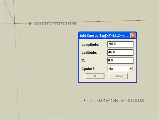
The Add Coords-Tag by Dialog and Import Coords-Tag from CSV (in LL units) are the elusive gems.
-Geo
-
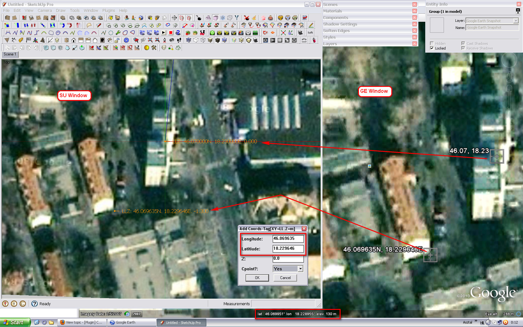
I think I got it, guys. Please, confirm that in the input dialog, the Lat and Log lines are changed. What you enter as longitude, should be latitude and vice versa. Try to enter into the Longitude line what you'd enter into the Latitude line and vice versa. See also attached screenshot. My SU window is floating above my GE window so bot co-ordinates can be seen.
By the way, Geo, if you really want to geolocate your model in SU 8, never use the map but the manual location field. Only then "add imagery". It's a couple of metres off otherwise (I know it would not be needed in the particular case you are after just mentioning).
-
So.... is it 'broken' ?
And if it is what do I [we] need to do to fix it ?? -
Hello TIG & Gaieus,
I just got back to see Gaieus’ post.
Let me try Gaieus’ solution and post how it works for me.-Geo
-
@tig said:
So.... is it 'broken' ?
And if it is what do I [we] need to do to fix it ??No, it works perfectly. Just swap the Longitude and Latitude texts in the dialog. This way it is misleading because we need to enter the values swapped.
This (line 799-803):
<span class="syntaxdefault"> if xyunits</span><span class="syntaxkeyword">==</span><span class="syntaxstring">"Latitude_Longitude"<br /></span><span class="syntaxdefault"> p0</span><span class="syntaxkeyword">=</span><span class="syntaxstring">"Longitude; "<br /></span><span class="syntaxdefault"> p1</span><span class="syntaxkeyword">=</span><span class="syntaxstring">"Latitiude; "<br /></span><span class="syntaxdefault"> xyus</span><span class="syntaxkeyword">=</span><span class="syntaxstring">"LL"<br /></span><span class="syntaxdefault"> else<br /> </span>should be
<span class="syntaxdefault"> if xyunits</span><span class="syntaxkeyword">==</span><span class="syntaxstring">"Latitude_Longitude"<br /></span><span class="syntaxdefault"> p0</span><span class="syntaxkeyword">=</span><span class="syntaxstring">"Latitude; "<br /></span><span class="syntaxdefault"> p1</span><span class="syntaxkeyword">=</span><span class="syntaxstring">"Longitude; "<br /></span><span class="syntaxdefault"> xyus</span><span class="syntaxkeyword">=</span><span class="syntaxstring">"LL"<br /></span><span class="syntaxdefault"> else<br /> </span>"Latit
iude" is misspelt there anyway (good it was not in the code - although then it would have turned out at least - and I could hardly find it as I did not notice the misspell first and was also searching for "Latitude" in NP++) so it could bear an update.

-
That solved that problem, Gaieus.

Now to try this on the ‘Import Coords-Tags from CSV’ tool.
Note the coordinates entered in the dialog are the reverse of those in Model Info-Location
Yet, the LL-Tag it creates is correct.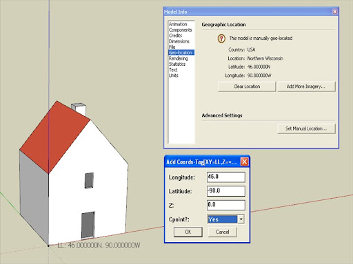
-Geo
-
Oh, I am really glad. When I was torturing TIG along this whole topic until we got where the plugin is, I mainly concentrated on the other aspects of it (custom, ortho-co-ordinates) as Didier by then had come out with his LatLong tool and in this plugin here it was just an "extra" for me (but of course, important one) so did not notice this little glitch.
Anyway, I hope you enjoy it as much as I do (and of course, many thanks to TIG again)
I think in that Help Forum topic I overcomplicated the thing with the PhotoMatch thing as the guy does not seem to need it as accurately.
-
OK, so I went along and did the changes in the code I wrote above and success; it works perfectly!
-
Here's an update http://forums.sketchucation.com/viewtopic.php?p=284829#p284829
It should now work ! as Gaieus explained the prompts were wrong .
At least I've got him to delve into the bowels of a script AND fix it himself!!
We'll make a scripter of you yet Csaba!!!I fixed the typo in the 'Add' dialog prompts' text.
I've also add +/- clues in them to avoid users West of Greenwich getting confused by Longitude!
Also now the 'Add' dialog's values of the Lat/Long start off with the model's origin Lat/Long and thereafter use the last used values... -
@george said:
@gaieus said:
OK, so I went along and did the changes in the code I wrote above and success; it works perfectly!
OK. I’ll change the code and report back.
Perhaps that is also what is causing the problem with ‘Import Coords-Tags from CSV’.

The script will export LL-tags to CSV file perfectly.
Nothing happens when I try to import a CSV file in LL units.I’ve tried importing CSVs I created and I’ve tried importing one of the CSVs the script exported.
Neither CSV will work. I also tried reversing Latitude and Longitude in the CSV file. Niente.
‘Import Coords-Tags from CSV’ does work if I specify length units and not LL
-Geo
Geo - no need to change the code - get v1.7, it's fixed!!!
'Import Coords-Tags from CSV'
This imports all of the 'Coords-Tags' into the Model from a CSV file in
to format X,Y,Z or LAT,LONG,Z - the values must be comma separated and
consist of numerals only with '.' as the decimal separator, one point
per line.
A dialog then requests the 'units' used in the CSV file for XY and Z,
and if you want to add Cpoints [defaults are 'm' and 'Yes'].
If the CSV file has a 'header' line etc it is ignored.
Is this what you are doing ?
Hello! It looks like you're interested in this conversation, but you don't have an account yet.
Getting fed up of having to scroll through the same posts each visit? When you register for an account, you'll always come back to exactly where you were before, and choose to be notified of new replies (either via email, or push notification). You'll also be able to save bookmarks and upvote posts to show your appreciation to other community members.
With your input, this post could be even better 💗
Register Login


Advertisement