Plot Plan Boundary Line Angle
-
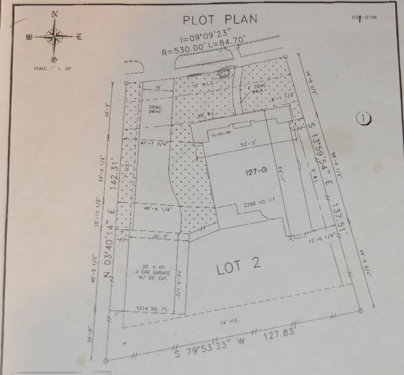
Hi All. I have a plot plan for my lot, and (being the lazy guy I am) I'm looking for an easy way to draw the plot.
I have the dimensions of my lot. For instance, the southern most boundary line is 127.83' long. For the angle, it is marked S 79°53'23" W.
How do I translate S 79°53'23" W into a rotation angle in SketchUp?
Also, the top boundary "arc" is marked
I=09°09'23"
R=530.00'
L=84.70'I get the R and L, but what would be the I?
Thanks, Todd
-
I think this is what you want - 'Survey Tool' - it's linked here... http://forums.sketchucation.com/viewtopic.php?p=220368#p220368
-
ok, I'm figuring this out. I think.
On this line, the 79° 53' 23", I would convert the 53' and 23" to a fraction of a degree, via (53/60) + ((23/60)/60), or roughly .88971, so that's 79.88971°. And, it seems to be about right, that if this line were vertical, and I rotated clockwise 79°.88971 about the bottom point, it would appear to match my drawing.
Still don't understand the S & W designations though. Or the I.
-
N nnn E is nnn degrees towards E starting at N, i.e. clockwise.
N nnn W is nnn degrees towards W starting at N, i.e. counter-clockwise.
S nnn W is nnn degrees towards W starting at S, i.e. clockwise again.Is 'I' an angle of inclination and the R/L are offset to the Right/left sides from a point ?
-
Thanks TIG. I found a reference on the net:
@unknownuser said:
These numbers are surveyors notations that tell which way the lot line runs. In this case, it is read "North 40 degrees, 33 minutes, 57 seconds East." It means that starting at the southern corner of this lot, the southeast lot line runs in a direction 40 degrees, 33 minutes and 57 seconds east of a line drawn due north from the southern lot corner.
Also, thanks for the link to the script.
-
For I, I don't know. Here's the plot.
-
Hi Todd
The upper boundary with a combo of line and curve does not look like there is data for each.
That is a line length and direction as well as an arc description of radius and segment.
You will need both to make the survey close.
If nothing is to be built in the "front yard" area you can just make a good guess for the arc.Good enough for Jazz.

Good luck with the project.
Dave
-
'R' = Radius of the arc at the front boundary ?
'I' Degrees'" is perhaps more usually shown as a triangle (Delta) and gives the direction that the 'lot curve' goes - in this case ~9 degrees ?? It is the bearing [Inclination] of the arc's 'central-angle' ??
'L' is the Length of the arc = ~84' measured across the two front pins - if you set out the other sides then what's left should be about that dim - measured on the curve's part-circumference [or chord ?] ??? -
Todd
I missed the upper boundary data it as it is above the P.L. not right on it.
If you have a problem with the arc segment you can just draw an arc with the noted radius and then move it in to fit and close.
 DUH
DUHDave
-
Like this - Survey-tool + hand-drawn bearing line and true-intersecting circles...Plot.skp
-
Thanks TIG and Dave!
-
I love laying out Site Plans (having been taught the proper way to do it by hand by an architect I used to work for) but have never run into an "I" before. My assumption (like TIG's) was that it was the Delta.
I laid out the side and rear lines in DataCAD (my cadd of choice) and then started playing around with the radius front property line.
Based on my layout, it appears to be the angle of the arc's CHORD (between the chord and a line drawn due east).
Thanks for the challenge - this was fun!
-
Hey Todd
Tig always comes to the rescue.
Have Fun with the survey in SU time.
Good weekend to everbody.Dave
Hello! It looks like you're interested in this conversation, but you don't have an account yet.
Getting fed up of having to scroll through the same posts each visit? When you register for an account, you'll always come back to exactly where you were before, and choose to be notified of new replies (either via email, or push notification). You'll also be able to save bookmarks and upvote posts to show your appreciation to other community members.
With your input, this post could be even better 💗
Register Login


Advertisement