Great plug-in - a really handy tool. Thank you.
Latest posts made by jack_sprat
-
RE: Georeferencing poor match
Aerilius, hello
I'll take this opportunity to sing your praises for the excellent and helpful post describing how to get SU running on Linux (mentioned above) - thanks.
@unknownuser said:
I assume when you adjusted the models drawn on OpenStreetMap plan to the Google Maps satellite image, you moved the models (and did not unlock and move the terrain).
- definitely - GE terrain remained locked throughout. (Also, 'OS' is Ordnance Survey, the UK govt. cartographers).
@unknownuser said:
What happens if you create a new (not geo-referenced) model and add a terrain using "Add Location", then import your geo-referenced model file into this?
- that's what I suggested I would do next in my 3rd post... and now I've done it. It works a treat - AND, I didn't have to move any of the model, i.e. the imported model was correctly geo-referenced, all along.
So it seems that adding terrain from GE after creating and geo-referencing a model screws with the geo-referencing; even though the model location tag in the exported KML is the same as the manually specified geo-reference for the original model:
    <Placemark>
      <name>Model</name>
      <description></description>
      <Style id="default"/>
      <Model>
        <altitudeMode>relativeToGround</altitudeMode>
        <Location>
          <latitude>dd.dddddd</latitude>
          <longitude>-d.dddddd</longitude>
          <altitude>0</altitude>
        </Location>
        ......
    </Placemark>
Lesson learned!
thanks for your interest - JS
-
RE: Georeferencing poor match
FYI:
I followed installation as per: http://sites.google.com/site/sketchupsage/problems/linux;
I initially had issues with openSUSE12.1, but these were resolved with Wine1.3.35, as per http://bugs.winehq.org/show_bug.cgi?id=29404(just noting these in case someone picks up this thread while searching for similar solution)
JS
-
RE: Georeferencing poor match
Gai,
FYI: Adding the terrain was kind of an afterthought, having built a model of a proposed house-build on a plot adjacent to the buildings you see in the screen-grabs in my OP. The OS map has the plot boundary on it (which obviously isn't part of GE imagery).
It seems that the order in which the various steps are undertaken is critical, i.e. you can't reliably add GE terrain to an already georeferenced model. I find this surprising, particularly when using 'Add more imagery...' tool zooms directly to the zeroed axes of the defined model.
I will re-build the model, with imported GE terrain as the base.
I wonder (but doubt) whether the fact that I'm running SU8 under Wine (1.3.36) on a Linux (openSUSE 12.1) machine has any bearing on the issue...
best - JS
-
RE: Georeferencing poor match
I did indeed already have the model georeferenced before grabbing the terrain, but this would've been no more than 300m from the GE terrain location.
I guess that my process is actually:
Georeferenced and positioned an image of an OS map of the area (~ 400m x 450m)
Built a rough model of a bunch of Nissen huts and water towers, using the OS map.
Grabbed terrain from GE in SU, using 'Add more imagery...' tool.
Re-positioned OS map and model against the GE snapshot image.
Adjusted heights to match GE terrain.
Exported model to KMZ.
Imported KMZ into GESo, maybe it is 'more imagery' because of the pre-existing OS map PNG.
Is the fact that I didn't grab the GE terrain first really likely to be the issue?
I just tried a test, using the procedure I originally posted - this results in ~2.5m offset, but good vertical referencing.
Interesting.
JS
-
Georeferencing poor match
Hi - my first post, so hello.
I'm trying to load a SU model into GE; here's my process:
I've grabbed terrain from GE in SU, using 'Add more imagery...' tool.
I have an image of an OS map of the area (~ 400m x 450m), which I've georeferenced against the GE snapshot image.
I built a rough model of a bunch of Nissen huts and water towers, using the OS map.
Checked the position against the GE snapshot.
Adjusted heights to match GE terrain.
Exported model to KMZ.
Imported KMZ into GE.and... the results are pretty poor, both horizontally and vertically.
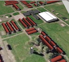
SU model:

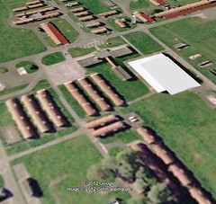
same view in GE:

the keen-eyed amongst you will spot the difference!
The model appears to laterally offset by ~5m, and vertically by ~2m.
Is there a step I've missed?
Do I have re-reference the model somehow?I'd really appreciate some hints.
thanks - JS