How to make a 2:1 slope on a topographic drawing?
-
Is there a method or plugin to create a specific slope on a curving, irregular, line?
I have a topographic plan that I've imported into Sketchup.
I drew the lot boundaries with a 10' offset and projected them onto the topo.
I need to create a 2:1 or 3:1 slope towards the center of the site.
The best method would be something like a chamfer where I can specify the angle.
(I've already tried: Follow Me, 1001bit tools slope and it's version of follow-me, extruding and scaling the bottom face, and fredo6 roundcorner.)
-
I don't normally try to make specific edits to topography. instead if I have a topo or if I have a structure, I will build the new topo and then build the geometry from it.
Does this have to be precise? can you not manually make the changes? If so the sandbox tools will help greatly. or if you want to spend the best $25 of your life you can buy Vertex Tools. http://www.thomthom.net/software/vertex_tools/
here's a list of land editing tools I've made.
Survey Tool - Free
http://rhin.crai.archi.fr/rld/plugin_details.php?id=434TopoShaper - Free
http://sketchucation.com/pluginstore?pln=TopoShaperTig Cut-N-Fill - $20.00
viewtopic.php?f=323&t=55250Instant Road Nui - $28.00 Per Year Subscription SU2014
http://www.valiarchitects.com/subscript ... t-road-nuiInstant Road - $25.00 SU 2013 and under
http://www.valiarchitects.com/sketchup_ ... stant-roadInstant Site Grader - $15.00 SU 2013 and under
http://www.valiarchitects.com/subscript ... ite-graderInstant Site Grader Nui - $15.00 Per Year Subscription SU 2014
http://www.valiarchitects.com/subscript ... grader-nuiInstant Terrain - $7.00 Per Year Subscription
http://www.valiarchitects.com/subscript ... nt-terrainSimplify Contours Tool - Free
http://extensions.sketchup.com/en/conte ... tours-toolIn the end... I think manual will be the cleanest way. and when I say that... know that I mean selecting entire topographical elevation lines and then pulling them up or down to the placement you want and then using sandbox to drape over that.
-
I made the list of tools... Not the tools... I make no tools, I just point people towards people who make great tools.
-
check your links, some URL's looks like they're truncated, not working
@krisidious said:
I don't normally try to make specific edits to topography. instead if I have a topo or if I have a structure, I will build the new topo and then build the geometry from it.
Does this have to be precise? can you not manually make the changes? If so the sandbox tools will help greatly. or if you want to spend the best $25 of your life you can buy Vertex Tools. http://www.thomthom.net/software/vertex_tools/
here's a list of land editing tools I've made.
Survey Tool - Free
http://rhin.crai.archi.fr/rld/plugin_details.php?id=434TopoShaper - Free
http://sketchucation.com/pluginstore?pln=TopoShaperTig Cut-N-Fill - $20.00
viewtopic.php?f=323&t=55250Instant Road Nui - $28.00 Per Year Subscription SU2014
http://www.valiarchitects.com/subscript ... t-road-nuiInstant Road - $25.00 SU 2013 and under
http://www.valiarchitects.com/sketchup_ ... stant-roadInstant Site Grader - $15.00 SU 2013 and under
http://www.valiarchitects.com/subscript ... ite-graderInstant Site Grader Nui - $15.00 Per Year Subscription SU 2014
http://www.valiarchitects.com/subscript ... grader-nuiInstant Terrain - $7.00 Per Year Subscription
http://www.valiarchitects.com/subscript ... nt-terrainSimplify Contours Tool - Free
http://extensions.sketchup.com/en/conte ... tours-toolIn the end... I think manual will be the cleanest way. and when I say that... know that I mean selecting entire topographical elevation lines and then pulling them up or down to the placement you want and then using sandbox to drape over that.
-
Thank you Krisidious. None of those programs do what I need.
I do have to be exact, it is part of the Building Code.
I am trying to figure out site placement of a home and reduce the amount of retaining walls.
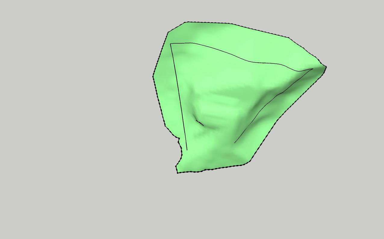
In the picture I attached, the green surface is the existing Topo. i need to slope everything towards the center of the shape, from that black line drawn on the topo. That line isn't on one plane, so it isn't a single contour line.
Manual doesn't work because there are probably a thousand points.
-
The approach is more about what sort of terrain object you need in the end. Shall it be evenly divided in quads or simple faces? How is it to be blended with the rest. How clean is the form? In most cases, given that I have an existing terrain, I would make a very rough model of the area to be "graded" and how it would blend to the non-graded areas. I would use Artisan sculpt tool, mostly using "flatten" with shift key to approximate the model on a copy of the existing terrain. This is imprecise, but most like the final grading would occur at a house site.I would try to maintain a quadrilinear grid of the terrain.
But there are other ways, such as using a simple angular model then smoothing it with Artisan. You might make a uniform terrain afterward using Instant Terrain.
You might use my little tool
 to check it: http://sketchucation.com/forums/viewtopic.php?f=40%26amp;t=47683
 -
 +1
+1 
Hello! It looks like you're interested in this conversation, but you don't have an account yet.
Getting fed up of having to scroll through the same posts each visit? When you register for an account, you'll always come back to exactly where you were before, and choose to be notified of new replies (either via email, or push notification). You'll also be able to save bookmarks and upvote posts to show your appreciation to other community members.
With your input, this post could be even better 💗
Register Login


Advertisement