[Plugin][$] TopoShaper - v2.7b - 30 Jan 26


-
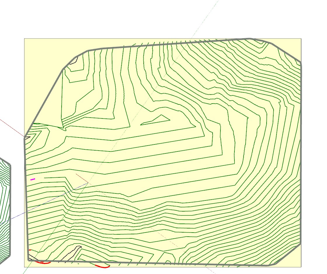
Hi I love this tool but am doing something wrong here? When I run Toposhaper on my contours it expands the countours beyond the shape of the area? Is there a way to switch this off so it stops at the boundary footprint? I want to compare to identical shapes in terms of footprint. This is the first one. They both have identical footprints but different contours.
Does anybody have any documentation on what the parameters and options on the Selection screen do such as Limit prolongation on edge crossing??
Thanks
-
Currently TopoShaper IsoContours compute the hull based on contours. In this version, there is no way to specify a particular hull.
I notice also an area where you are going to have problems with the calculation of the terrain, because you have contours crossing each other. I suggest you clean up this area before using TopoShaper.
-
Hi Fredo Thanks for the response. I cleaned it up and it still makes no difference.
For my own education what do the options on the Selection panel do? Such as Limit prolongation on edge crossings?
-
@grey24601 said:
For my own education what do the options on the Selection panel do? Such as Limit prolongation on edge crossings?
A said, there is no way to address your problem in the current version. The terrain hull is computed automatically and cannot be specified.
-
I'm stresstesting Toposhaper:Cloud as i type.
I've imported 57 816 points with z-values from a dwg file.
Any predition - will it work with this amout of points?
-
@josefen said:
I'm stresstesting Toposhaper:Cloud as i type.
I've imported 57 816 points with z-values from a dwg file.
Any predition - will it work with this amout of points?
Not sure, but you'll have time for more than a coffee...!
I suggest that you first start on a subset of points. Be aware that if you have a dense mesh of points, you may have some spikes in the terrain, because the surface goes through ALL points.Anyway, once you have constructed the terrain as a triangular mesh, you can generate the iso contours, and then use the TopoShaper QuadMesh to make it smoother and more regular.
Fredo
-
Toposhaper was not letting me increase my grid it would get stuck at 50% so I uninstalled and reinstalled both Toposhaper and Lib and now it is crashing when I try to generate terrain at all.
-
@kmam said:
Toposhaper was not letting me increase my grid it would get stuck at 50% so I uninstalled and reinstalled both Toposhaper and Lib and now it is crashing when I try to generate terrain at all.
This is a very unusual error. Could you post of PM me the model and the desired grid resolution.
Fredo
-
I sent a PM
-
NEW RELEASE: TopoShaper v2.5c - 29 Oct 19
Requirement: LibFredo6 8.7a
TopoShaper 2.5c is a maintenance release for bug fixing.
Home Page of TopoShaper for information and Download.
-
Thanks again for your generosity
-
Merci Fredo, tes plugins me sont très utiles, voire indispensables pour certains travaux.
Zooen
-
First Fredo, "Mille mercis", Thank you so much for all your plugins. They are invaluable...
I like and use a lot TopoShaper and i have a request. Could it be possible to add some editing tool for Cloud Points as you did for contours: set CP to a specified Z, remove CP, Add CP at specified Z ?
This will greatly speed up the process of building a nice and clean topography for projects (like for example the site tools in Revit where you just build some topo points by giving the altitude).
Kind regards,
thanks again
and Excellentes fêtes de fin d'annéeXtov
-
@xtov said:
Could it be possible to add some editing tool for Cloud Points as you did for contours: set CP to a specified Z, remove CP, Add CP at specified Z ?
This is in my plan and will be fully addressed in a new plugin called FredoGuides.
I think there are some plugins doing what you are looking for, for instance Thomthom Guide Tools.
Possibly, you may want to have a look at FredoTools:DrawAlong, which allows to create guide points and specify their position.
But I agree that a dedicated tool would be better.
-
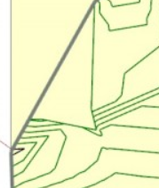
Do you think this plugin will work for details like this or no?

-
@sketchartist023 said:
Do you think this plugin will work for details like this or no?
Difficult to judge, but what is sure is that
- you need to clean up the crossing lines, and also 'artificial' contours that do not seem to belong to the terrain itself.
- A lot of the small rounds may be useless, unless you use a high-resolution grid
Anyway, the best is to try and see.
-
@fredo6 said:
@sketchartist023 said:
Do you think this plugin will work for details like this or no?
Difficult to judge, but what is sure is that
- you need to clean up the crossing lines, and also 'artificial' contours that do not seem to belong to the terrain itself.
- A lot of the small rounds may be useless, unless you use a high-resolution grid
Anyway, the best is to try and see.
I did just that, and the biggest difference that made no errors were the artificial contours, specifically the very outer border. WHich makes sense because z x and y would all equal the same (therefore an error), so once I deleted those and did a clean (based on the instructions of iso usage), it worked very well!
Check it out


-
The resolution is also very acceptable considering the width of this model test is only 4 inches

I will read how to change resolution in case I need those smaller ones that you mentioned too. Hopefully, for 3d printing purposes, it will be useful to keep
Thank you much for your help!

-
Wish me luck lolz
And yes, this was all done by hand so far. Wish could use the js align tool but I have to learn it first Progress is progress!

-
@sketchartist023 said:
The resolution is also very acceptable considering the width of this model test is only 4 inches
I will read how to change resolution in case I need those smaller ones that you mentioned too. Hopefully, for 3d printing purposes, it will be useful to keep Thank you much for your help!I think your model would benefit from a higher resolution, as the terrain is basically flat with some very local deeps.
Also, you can always generate the terrain with its new isocontours (which would be clean), and then
- extract the group with these isocontours
- use them to regenerate a new terrain, possibly with another resolution.
Fredo


Advertisement