Sketchup 8pro and surveying/drafting
-
@eddix99 said:
The great thing about doing things within sketchup is that you can simply just grab the rotate tool and realign your data so that it fits. This means that you can get away with getting your backsight sorted AFTER you do your survey. As long as the data is in the right position from the station I would imagine it to be pretty easy to align it with existing points.
Edward,
That's the key..making sure you have enough good reference data to align the data properly. If you establish fixed reference points around the perimeter of the site you should be able to add as many additional stations as necessary.
The fixed points will need to be stable, and they can be something temporary like a ground stake. Once you establish the location of the reference points you can always go back and add more stations/measurements to the survey as required.
If you have problems with the lines intersecting you can always use construction points instead. You only need the endpoint from the instrument measurement lines and you can create those using the construction point tool.
The XYZ coordinate concept is pretty simple..In the Sketchup 3D coordinate system points in space are identified by position along the three drawing axes:
+X is the solid red line, -X is the dotted red line (right - left)
+Y is the solid green line, -Y is the dotted green line (in - out)
+Z is the solid blue line, -Z is the dotted blue line (up - down)One thing I did notice is that looking at your Sketchup file it looks like you have the axes rotated so that the +Z axes is pointing down..I'm not sure why it's that way, but it is opposite of how it normally would be.
I don't know what the site your mapping looks like or what obstructions there are, but I added generic alignment point locations to this picture of your layout to show you what I'm talking about..as well as a view using construction points in place of the measurement lines.


-
Hi All,
I am new to sketchup an currently using sketchup make 2014 on a Mac. I have downloaded the surveytool.rb file from http://rhin.crai.archi.fr/rld/plugin_details.php?id=434 but the plugin is not appearing in the draw menu.
Unlike on PC, there is no plugin folder on the Mac version, so I can't even drag and drop the surveytool.rb file into the plugin folder.
Has any mac users experienced this or know how I can get this plugin to work on sketchup make 2014 for mac.
Thanks in advance
-
@etbandit said:
Unlike on PC, there is no plugin folder on the Mac version, so I can't even drag and drop the surveytool.rb file into the plugin folder.
Ah, but there you're wrong. There is a Plugin folder on the Mac for SketchUp 2014. The path is under ~/User/Library/Application Support/... but don't worry about it.
@etbandit said:
Has any mac users experienced this or know how I can get this plugin to work on sketchup make 2014 for mac.
Thanks in advance
Do this:
-Find the downloaded .rb file on your computer.
-Right click on it and choose Compress. This should make a ZIP file containing the .rb file.
-Right click on the ZIP file and choose Get Info.
-Change the extension from .zip to .rbz.
-Now open SketchUp.
-Click on the SketchUp menu to the left of File.
-Go to Preferences>Extensions.
-Click on Install extension...
-Navigate to the rbz file you just created.
-Select the rbz file and choose Open.
-Click on Yes and then OK.
-Close Preferences.Look in the Draw menu for Survey Tool. If you don't see it, quit SketchUp and reopen it.
-
Thanks heaps Dave R!
Your step by step run down was most helpful.
Cheers
-
Apologies for the novice questions, but If I had metes and bounds as shown in the diagram below for input into sketchup via the survey tool (and given that 1 Degree = 60 min and 1 min = 60 seconds, would I then (using the top right corner of the diagram as the POB) enter the following converted values into the survey tool pop-up window?:
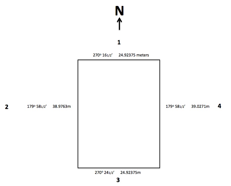
- N 89deg 43' 30" W 24.92375m
- S 0deg 1' 30" E 38.9763m
- S 89deg 35' 30" E 24.92375m
- N 0deg 1' 30" W 39.0271m
Thanks in advance
Cheers. -
It works for me. What do you get when you try it? Keep in mind that due to the angles and differences in lengths, it isn't unlikely that you'll have an open corner somewhere.
-
Yeah, works for me too.
Not sure why they haven't listed the bearings the conventional way though (ie, degees east or west of North or south.
Cheers.
Hello! It looks like you're interested in this conversation, but you don't have an account yet.
Getting fed up of having to scroll through the same posts each visit? When you register for an account, you'll always come back to exactly where you were before, and choose to be notified of new replies (either via email, or push notification). You'll also be able to save bookmarks and upvote posts to show your appreciation to other community members.
With your input, this post could be even better 💗
Register Login


Advertisement