Please, help! Need to made 3D from huge DWG Contour file...
-
Dont know where to start on how to transform this DWG into a terrain... in Sketchup... adding streets could be easy with DRAPE, but then, how to pull up the sidewalks over the terrain??
I will attach the dwg file... if anyone can show me how to make a tiny part of it, I will take on the rest of the monumental task...
-
added the file below... had to compact it with Winrar however, because it was larger than 4mb
-
4Mb for a DWG file??! I think it needs purging & removing all "junk" not needed in SketchUP. If it's drawn by layer, you can try importing it into SKUP & deleting the excess layers, or wblock out the layers directly from AutoCAD into separate files.
-
ok, thanks. But and what then? How to proceed next to create a terrain mesh from those lines?
-
Hi AcesHigh,
I think that these 2D drawings are from a originate CAD Road planning application. I think that you can not use these drawings to create a 3D terrain. I've ever dealt with such programs for a while. And if I'm not mistaken, the model must be exported from the corresponding 3D CAD program as a 3D DXF file or a point cloud file.
Regards Charly
-
@charly2008 said:
Hi AcesHigh,
I think that these 2D drawings are from a originate CAD Road planning application. I think that you can not use these drawings to create a 3D terrain. I've ever dealt with such programs for a while. And if I'm not mistaken, the model must be exported from the corresponding 3D CAD program as a 3D DXF file or a point cloud file.
Regards Charly
Can I do that myself, opening the DWG file in Autocad and re-exporting it again???
should I export one layer at a time as a 3D DXF file?
-
Hi AcesHigh,
I'm not a CAD specialist. Do you know the software which were created these drawings with? If yes, is there a digital terrain model stored? If you import these drawings into Autocad You have also only 2D drawings.
Have a look here: http://diolkos3d.com/index.htm
Charly
-
You have lots and lots of redundant information in the CAD file.
AND unfortunately it's all 2D !
You do have contours but again these are all drawn 'flat'.
Perhaps if you edited the CAD file and kept just the contours, long sections and road curbs etc... and gave 'elevation' [height] to the contours then maybe you could import that reduced set of info into a SKP and use the Sandbox tools to convert From Contours into a mesh... Then add faces to the 2D road plans and Sandbox Drape them over the land surface ? -
What is "TIG" says is true. You'd have every height measurement point from the graph, set with the contour lines and the road in relation to it and construct the terrain. But that would be a hard work.
-
@tig said:
You do have contours but again these are all drawn 'flat'.
yes, I know

@unknownuser said:
Perhaps if you edited the CAD file and kept just the contours, long sections and road curbs etc... and gave 'elevation' [height] to the contours then maybe you could import that reduced set of info into a SKP and use the Sandbox tools to convert From Contours into a mesh...
ok, in theory you can do that directly from Sketchup, cant you? But I guess selecting the lines and cleaning the file on Sketchup would be harder...
@unknownuser said:
Then add faces to the 2D road plans and Sandbox Drape them over the land surface ?
yes, but how to pull up the curbs? And how to make the road flat??
As far as I understand, if I drape the road plan over the mesh, it will only crate "cut lines" over the mesh. But it will still follow all the mesh contours.
-
@aceshigh said:
yes, but how to pull up the curbs? And how to make the road flat??
No, you won't drape but stamp (and do not forget JointPushPull either). Just get the mesh in (in 3D) somehow and the road lines and we can go on from there.
-
hmmm, ok, but doesnt the stamp creates a TOTALLY flat surface on the mesh?
I mean... if I stamp the flat road plan on the mesh, how to make the road go up and down later?

-
With a little bit of manual work and the Follow me and keep plugin, you can easily create a road whose surface is horizontal sideways and even has a side walk with curb.
-
Road design is a technique that had interested me for a long time. In SketchUp, it is very difficult to construct a natural-looking street in an uneven terrain. The best tool I've ever seen for Sketchup till now is the Valiarchitects instant road plugin.
I've experimented with many programs, including GeoControl 2 and Diolkos Road Design (Prof. 3D CAD software).
Have a look at this topics: http://forums.sketchucation.com/viewtopic.php?f=18&t=19578&hilit=Road+design
http://forums.sketchucation.com/viewtopic.php?f=15&t=20053&hilit=Road+design&start=15
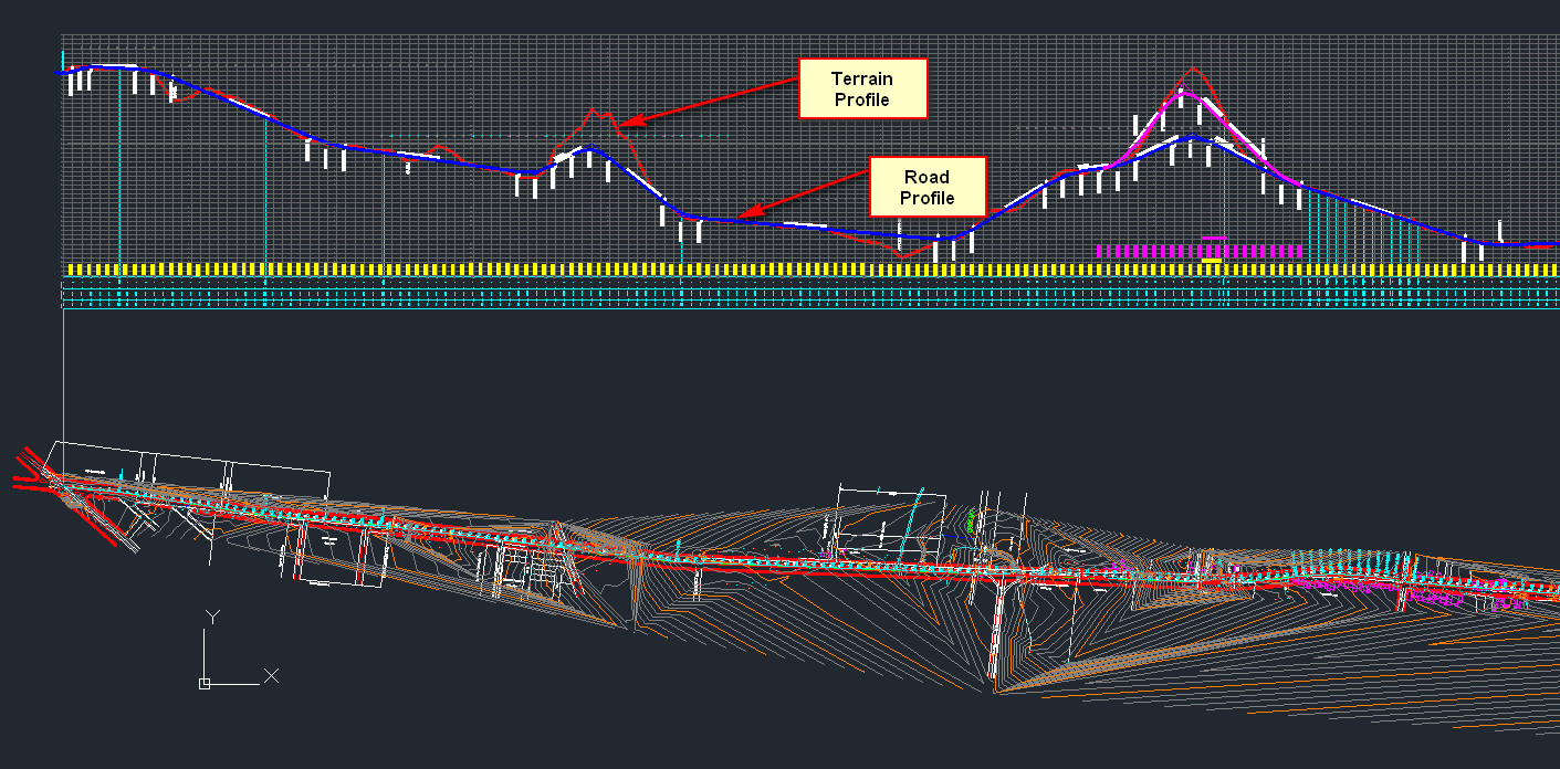
http://forums.sketchucation.com/viewtopic.php?f=81&t=29988&p=264804&hilit=Road+design#p264804For the development of a road in the terrain you need the actual height measurement points, and many other data. The program then calculates a DTM with the road. The results look like in your DXF file (without DTM). The area with the road can then be exported as 3D DXF file. But such programs are hard to master for us laymen.
Charly
-
Yes, I also remember Charly's experiments. And true that you will be unlikely to get a perfect solution but at least something. After all, this is probably not going to be the full construction drawing but "only" some 3D visualization of the idea.
-
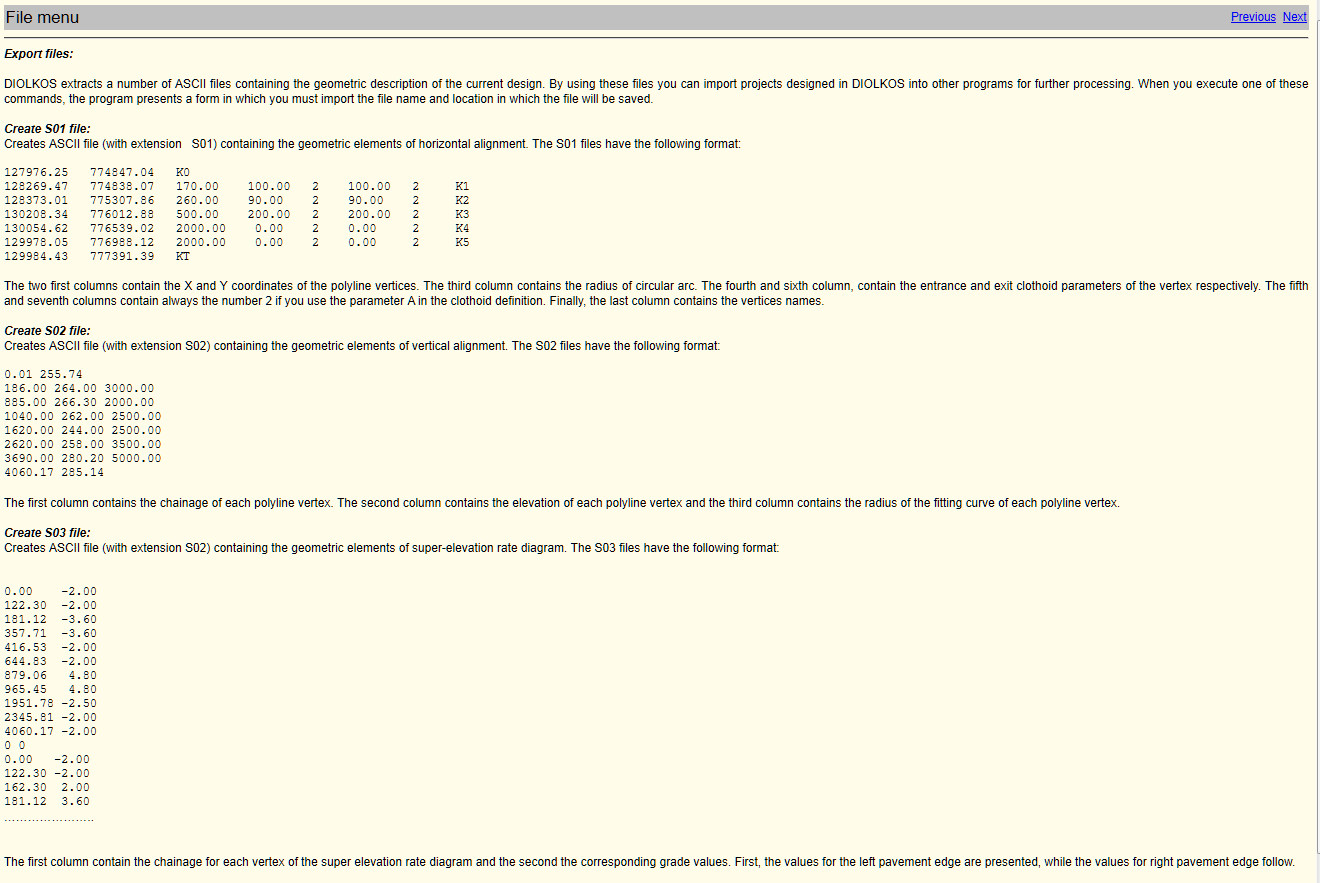
Hi,
I've once again seen the Diolkos software. There is no way to export a DXF. You can export the project into three different ASCII formats (see screen shot below). Is there a way to convert them so they can be imported into SketchUp?
Charly
-
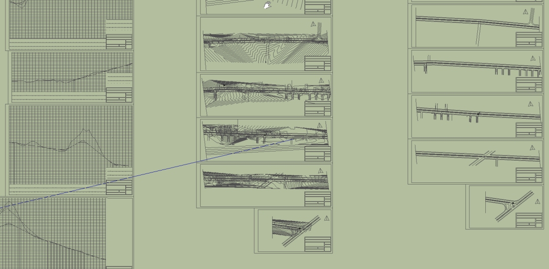
oh god damn... I just finished making the 3D Terrain (without roads yet). I only used the main contours (each 5 meters). Even so it was already a lot of work.
But to my surprise, when I created the mesh, some areas of the terrain have some severe problems, with faces appearing and disappearing when I rotate the mesh, or get close.
I went back some steps to when there were only lines in the model, and noticed that SOME LINES, when I get closer, also display strange behavior. In fact, some lines, when I get close and rotate around, make the whole screen "shake". Its very weird, but I had already noticed the same thing on some 3D models I once imported from autocad DWG file...
-
The disappearing bits are 'clipping' caused by geometry being far away from the origin, if you import CAD data with the 'preserve origin' ticked the imported geometry can be hundreds of kms away from the SKP's origin and cause the issue described. If the option is unticked the geometry arrives near the origin. If you are doing several 'connected' imports you have to keep the CAD origin so they will arrive aligned - however later you should Move everything nearer to the origin. Ensure everything is visible and not locked, select all and then Move picking a point near the geometry an typing [0,0,0] - or perhaps [0;0;0] if your locale uses ',' as a decimal separator!.
Also sometimes imported CAD blocks become components with origins [axes] miles away from the component's geometry which also has this affect - you can reset a component's axes by right-click context menu over it and selecting 'Change Axes'... -
@gaieus said:
With a little bit of manual work and the Follow me and keep plugin, you can easily create a road whose surface is horizontal sideways and even has a side walk with curb.
Hi Gaieus,
I've got the plugin, read the associated thread and tried it out on the model you posted here, but I just can't seem to replicate your results (with the cut and fill batters). Any chance you could annotate your example with a few tips? I have a relatively simple road that I want to cut down through some terrain.
Thanks
- Mick
-
Can you post the terrain and the road cross section?
Hello! It looks like you're interested in this conversation, but you don't have an account yet.
Getting fed up of having to scroll through the same posts each visit? When you register for an account, you'll always come back to exactly where you were before, and choose to be notified of new replies (either via email, or push notification). You'll also be able to save bookmarks and upvote posts to show your appreciation to other community members.
With your input, this post could be even better 💗
Register Login


Advertisement