How to use this type of data
-
I would appreciate if somebody could advice on how one can convert LiDAR data into meaninfull 3d model. Is there a specialist software or plugins for max or other software.
Also any idea how to create models from satelite based high resolution stereo image frames.
Any Help would be appreciated.
-
LiDar normally comes with their own software when you rent the lidar unit to convert their data into a 3d model of some sort.
I don't know how to convert stereoscopic images into 3d data. That would be cool. Seems like there are some users around who have a lot of background with this though.
-
@unknownuser said:
LIDAR data is usually available in four different forms: contours, digital elevation models, edited points, and raw points. The contour data is in shapefile format. The digital elevation models are in the USGS DEM format. The point data - both raw and edited - are in ASCII CSV (comma separated value) files.
The DEM is directly importable into a SKP.
There are several scripts to import CSV and make a triangulated mesh from the points.
Not sure about 'shapefile'
In what format is your data ?
If it's a LAS format then http://geocue.com/ might do a free converter to other formats.
http://www.cs.unc.edu/~isenburg/lastools/ also have some tools like las2dem, las2tin, las2txt etc -
Thank you Both Chris and Tig.
-
Tig
Which scripts would be for triangulating mesh from the points. I have just discovered that LiDAR data can come as points (.dxf).
-
If the DXF file contains CAD Points they'll import in Pro as Cpoints [aka Guide-points].
Then use a tool like my 'Triangulate Points' tool... http://forums.sketchucation.com/viewtopic.php?p=301274#p301274 to make a mesh from those preselected cpoints...If you have the cpoints in a plain TXT file of XYZ values or as CSV/TSV etc, then Didier Bur has a tool to import and then mesh those in one go...
Search the Plugins Index for such tools... -
Yes the file imports in SU as bunch of cpoints....I will try your triangulate plugin. Thanks again.
-
Well... I installed your plugin and it starts triangulating but after small amount of time SU goes into non responsive mode. I do not know if there is issue of number of points that SU can handle. I tried it on couple of different comps on SU 8. (64 bit Windows 7 ; dual 6 core, 32 Gb Ram , Nvidia Quadro 4000 GPU)
-
Unless a there are problems reported in the Ruby Console it doesn't necessarily mean it's broken, because Sketchup goes non-responsive doesn't mean it's stopped.
Let it run for a while and have a coffee and some cake.
When you come back you can always kill the process if it's not finished.
How many points are there?
With thousands of points it could take many many minutes to work out the mesh.
As every point has to be checked against every other to speed it up you could select approx 25% of the points [with a slight overlap] and make 4 meshes in 4 steps- it will be considerably faster than 1/4... On completion you then tidy them back up.
Another issue is that the points might be far far away from the origin and cause Sketchup/OpenGL issues ? If so select all of the cpoints imported and Move then to "[0,0,0]", and retry... -
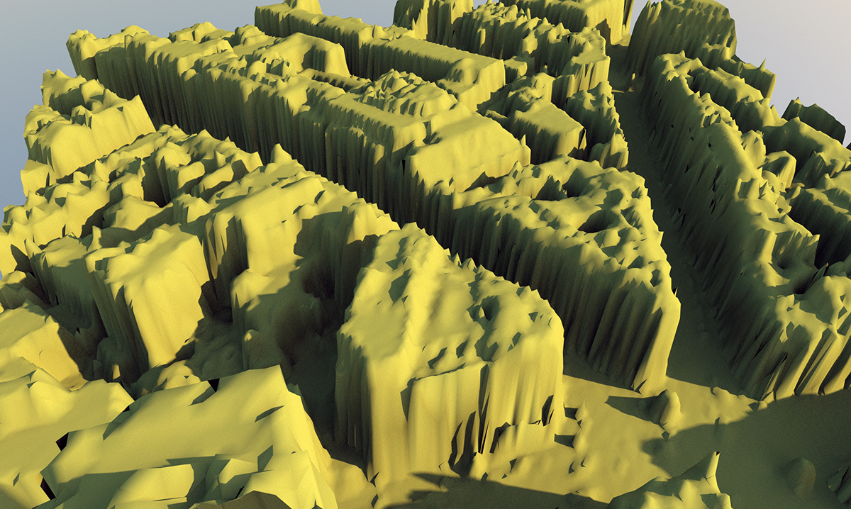
Here is how it looks like.
-
 Imported points data using delauney methods will 'melt' vertical objects as it needs to triangulate facets... some of which won't be what you'll expect.
If you can filter out the buildings in CAD and then export the 'site' mesh points that gives better results... -
Is there other method of triangulating which would be better for buildings.... as I am after buildings really?
-
I managed to do it but using SU8 on the Mac side. SU7 has no such problem on Vista. Kind of interesting.
It took nearly 3 hours and SU did not go non-responsive in both instances. Coffee was good and cake very moist.
The mesh turn out in not very usable state as buildings look like they are melting....maybe good for some Sci-Fi environment.....this Lidar data is kind of disappointing.
The file had 40406 points ... It created 80000 triangles. -
Not that I know of - the problem is working out which points make a facet.
IF the points are in a file and they are always arranged in sets so that they define a triangular face - like in many OBJ files - then it's much easier to replicate those facets in a SKP...
Unfortunately, the DXF data gets muddled once it's imported.
Are there any other file formats like csv/tsv/txt you can get the points data in?
These could be read into a SKP much more readily that a DXF... -
I see....I need to check if there are any other file types available.
-
Hmmm... It does not appear to be available. I was wondering if maybe this is all driven for Autodesk Map
-
You could try meshlab http://www.meshlab.org/ http://meshlabstuff.blogspot.com/
-
Thanks Notareal but as far as I know Meshlab does not import .dxf/dwg.
-
What does it export? If it will take any other sort of standard file type - csv, obj, anything?, maybe we can write an exporter for it.
-
@sepo said:
Thanks Notareal but as far as I know Meshlab does not import .dxf/dwg.
You don't get the LiDAR data in any other format? That unfortunate as meshlab is indeed a very good program to handle point clouds.
Meshlab
import:PLY, STL, OFF, OBJ, 3DS, COLLADA, PTX, V3D, PTS, APTS, XYZ, GTS, TRI, ASC, X3D, X3DV, VRML, ALN
export:PLY, STL, OFF, OBJ, 3DS, COLLADA, VRML, DXF, GTS, U3D, IDTF, X3D
Point Clouds support. Now 3D files that are composed only by points are well supported in PLY and OBJ format.
Hello! It looks like you're interested in this conversation, but you don't have an account yet.
Getting fed up of having to scroll through the same posts each visit? When you register for an account, you'll always come back to exactly where you were before, and choose to be notified of new replies (either via email, or push notification). You'll also be able to save bookmarks and upvote posts to show your appreciation to other community members.
With your input, this post could be even better 💗
Register Login


Advertisement