Large Terrain Mesh
-
@solo said:
If you can upload it, or part of it, I'd like to try something with Terragen.
I tried uploading it earlier and it was rejected because the file was too large.
-
Got a dropbox account? they are free, safe and private.
-
@solo said:
Got a dropbox account? they are free, safe and private.
No but I can get one. Where do you reccommend?
-
Install Dropbox for Windows and Mac
Dropbox helps you create, share, and collaborate on your files, folders, and documents. Learn how to download and install Dropbox for Windows and Mac.
(www.dropbox.com)
-
@solo said:
Install Dropbox for Windows and Mac
Dropbox helps you create, share, and collaborate on your files, folders, and documents. Learn how to download and install Dropbox for Windows and Mac.
(www.dropbox.com)
I'll go create an account now. What format do you prefer the data to be in? I am currently extracting it to a DXF mesh, is that ok?
-
Sure, or even DEM.
-
@solo said:
Sure, or even DEM.
The DXF mesh extract was huge and is still uploading to my dropbox but the DEM extract was surprisingly small. See attached:
-
You may want to check the dem file, it's kinda wierd, hard to explain, lacks all detail.
-
@solo said:
You may want to check the dem file, it's kinda wierd, hard to explain, lacks all detail.
I looked at it and see what you mean. I must have inadvertently selected the wrong scale when I exported it. The DXF file just finished uploading, here is the link:
-

 750MB file.
 gonna try open in SU first, see if flames spew out from CPU.
 -
@solo said:
:shock:
 750MB file.
 gonna try open in SU first, see if flames spew out from CPU.
See why I wanna reduce it? LOL
-
I doubt very highly that you can reduce that to a point it opens in SU and resembles anything close to what you need, but lets try, I have all sorts of tools to try with.
I'm trying Vue-SU first, but that will take a while to import.
-
@solo said:
I doubt very highly that you can reduce that to a point it opens in SU and resembles anything close to what you need, but lets try, I have all sorts of tools to try with.
I'm trying Vue-SU first, but that will take a while to import.
I do too but was going to divide it into several sections as to lighten the load of each.
-
@solo said:
I doubt very highly that you can reduce that to a point it opens in SU and resembles anything close to what you need, but lets try, I have all sorts of tools to try with.
I'm trying Vue-SU first, but that will take a while to import.
If I can figure out why my 90% reduction in Deep Explorer isn't coming out like yours, I believe my problem may be solved. I have tried numerous variations of settings but I start to lose detail at around 50% and it gets worse from there. I even managed to make what resembled a spiked cactus once.
-
@dbwv69 said:
What is GP?
Guide point.
I suppose you not knowing that implies that you never tried the method at all, but just were thinking that it would be way too much work - even just to try it? -
@bjornkn said:
@dbwv69 said:
What is GP?
Guide point.
I suppose you not knowing that implies that you never tried the method at all, but just were thinking that it would be way too much work - even just to try it?I'm willing to try anything that will help me to achieve my goal. Remember, I'm not a Sketchup expert, or an expert with 3D software in general, far from it in fact. By and large, I am learning as I go and will undoubtedly make a lot of mistakes along the way.
Honestly, and I am showing my ignorance here, but I am not completely sure what the guide point method entails. If you would care to enlighten me, I'd be happy to give it a try.
-
Solo, what settings did you use when you reduced the mesh sample I provided earlier? From what I can tell, the settings are very touchy and believe that's where the problem lies.
-
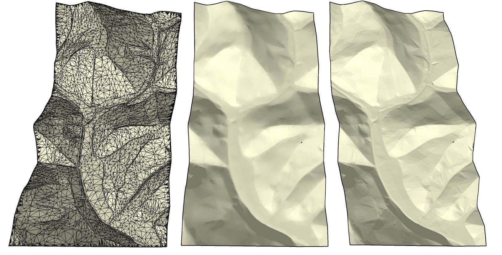
Just for fun I ran a quick test with Mootools Polygon Cruncher.
I removed 95%, and was left with 9770 faces from 198000. BTW, that dxf file is full of duplicated vertices.
As you can see on the leftmost version there's a lot of lines at the edges - that's because I told it to not touch the edges. Which means that all the edge vertices are exactly as in the original, and should very easily connect to the next patch as all the vertices should align.
The middle version is smoothed/softened and the right version is just softened with no normal smoothing.
I'm sure it could work fine even at more compression?
-
@bjornkn said:
Just for fun I ran a quick test with Mootools Polygon Cruncher.
I removed 95%, and was left with 9770 faces from 198000. BTW, that dxf file is full of duplicated vertices.
As you can see on the leftmost version there's a lot of lines at the edges - that's because I told it to not touch the edges. Which means that all the edge vertices are exactly as in the original, and should very easily connect to the next patch as all the vertices should align.
The middle version is smoothed/softened and the right version is just softened with no normal smoothing.
I'm sure it could work fine even at more compression?I'm impressed. The results you obtained look very much like the example Solo posted earlier. Now if only I could manage to do the same, my headache might go away and I could begin to do some real modeling. Though I must admit that I am not looking forward to the challenge of roadbuilding. LOL
-
@dbwv69 said:
I'm willing to try anything that will help me to achieve my goal. Remember, I'm not a Sketchup expert, or an expert with 3D software in general, far from it in fact. By and large, I am learning as I go and will undoubtedly make a lot of mistakes along the way.
Honestly, and I am showing my ignorance here, but I am not completely sure what the guide point method entails. If you would care to enlighten me, I'd be happy to give it a try.
Try anything? Except open your wallet ie
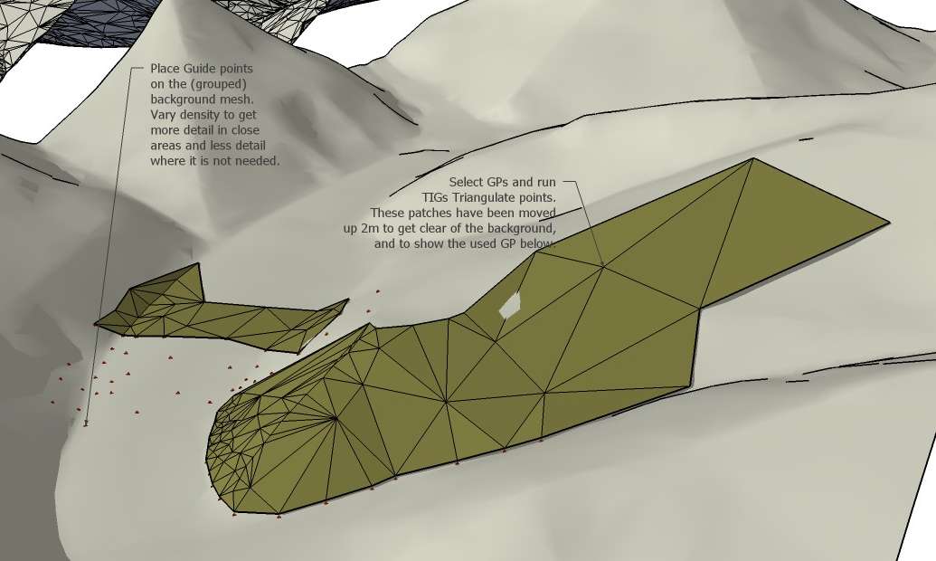
It's written on that image with 3 brown meshes posted a while ago.
Here is another "tutorial".
Advertisement


