Large Terrain Mesh
-
The first example (hand sketch) you posted reminds me of an idea that I had originally considered, where I thought about "tracing" over the grouped contour lines to capture all the major details (shape) of the mountains. After some brief experimentation, I quickly discovered that it would have taken forever to do because I wish to maintain as much detail as possible in the lower elevations and especially in the stream beds. It is still an interesting notion, however.
@bjornkn said:
@dbwv69 said:
That's probably a good idea because debating "free" v/s "paid" isn't doing a thing to help me achieve my goal. BTW: Did I detect a note of sarcasm there?
I'm afraid I couldn't hide it completely
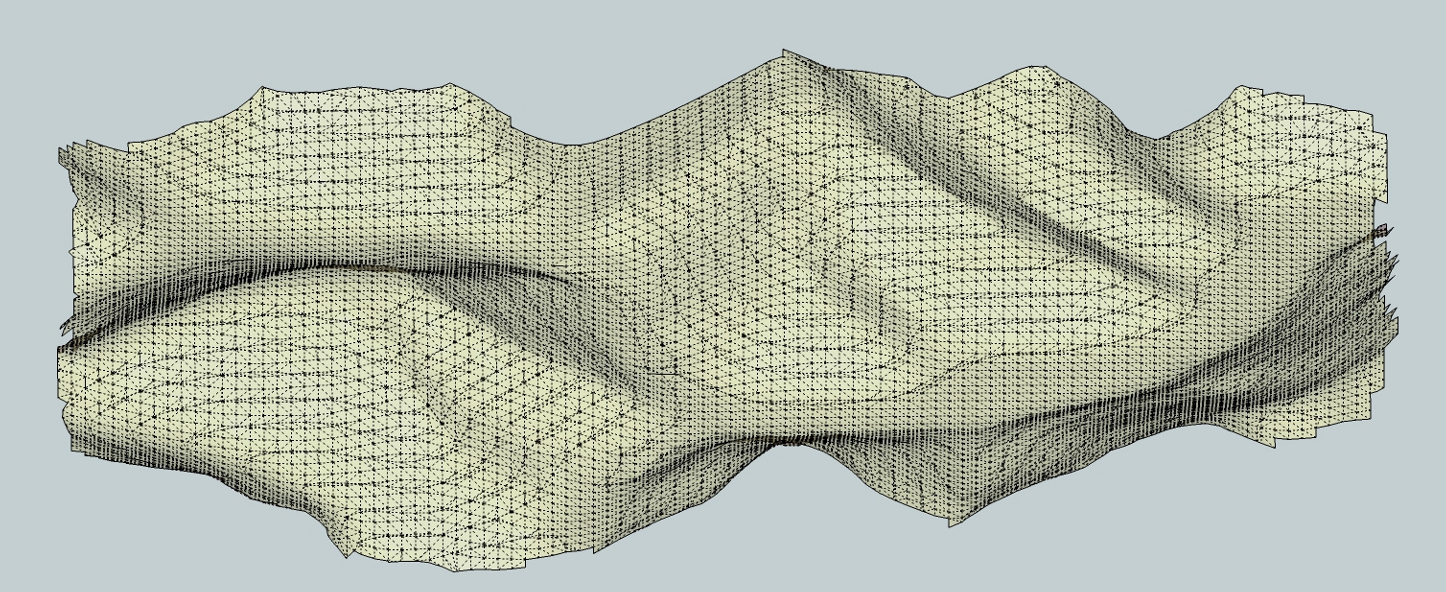
Nevertheless I couldn't resist wasting another hour+ on this terrain after you posted that "little" dxf detail.
All free tools (I think there are free guide point tools? Although I did use the one in Amorph)
I will not post the Amorph version... It didn't have a chance trying to polyreduce that beast of a terrain in any reasonable amount of time, but could easily build a terrain on top of the dxf.
[attachment=0:2qr61cuc]<!-- ia0 -->dxfterrs.jpg<!-- ia0 -->[/attachment:2qr61cuc] -
This is slightly off topic but I just had to say that I had a look at your website... NICE WORK!
@solo said:
Hey guys, I have not read this whole thread, I just jumped in here, I'm guessing it's about using large terrains, if not please ignore everything from here.
-
@dbwv69 said:
The first example (hand sketch) you posted reminds me of an idea that I had originally considered, where I thought about "tracing" over the grouped contour lines to capture all the major details (shape) of the mountains. After some brief experimentation, I quickly discovered that it would have taken forever to do because I wish to maintain as much detail as possible in the lower elevations and especially in the stream beds. It is still an interesting notion, however.
The amount of detail is entirely up to you, with full control, and would not take forever. Took about 10-15 min to place ~1400 guide points on the rightmost terrain.
I think you get a bit blinded by the massive amount of data in the mesh, and think that it must be precisely like that in real life. But in reality it shows a smoothed version (3x3m) of the terrain that looks like it's covered in fine sand or snow when you get close - no crisp details. It's like a heavily blurred photo. A real terrain doesn't look like that at all in the details.
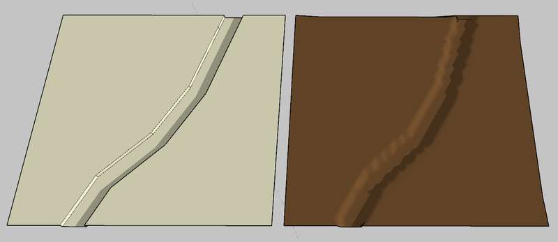
Here's a "stream" in a flat terrain, 15m wide and 3m deep with vertical sides - 15 faces.
On the right side is a "gridded" version with 3x3m resolution (using Terrain Reshaper - free) and ~8000 faces!
Doesn't look much like the "real" terrain, even though it has "much more detail"?
Do you have a photo of the area? Ground level? The shapes indicates that there must be lots of boulders, rocks, gravel everywhere?
Where is it?BTW, Solo wrote that he used Deep Exploration, which costs $400-$700 per year
Nice program though. I have an older version of the CAD/expensive version, bought when it was much cheaper and with no annual fees. No skp, Collada, FBX though. -
Thanks for the coordinates.
After having a look I'm even more confused why you insist on having all the details in the mountains, with ridge lines etc, when they are not visible at all because of all the trees?
The perceived landscape is even much smoother in the hilly areas than on my simplified versions. Not only will a more detailed version contain way too many faces, but it will also look wrong because you should really "model" the forests instead of the ground below, as it isn't visible anyway.
And at the same time you have the ground level with Lidar clutter, too little details and too smoothed. I think you'd be much better off with making this by hand. That way you may even end up with a full model that is managable in SU -
@bjornkn said:
Thanks for the coordinates.
After having a look I'm even more confused why you insist on having all the details in the mountains, with ridge lines etc, when they are not visible at all because of all the trees?
The perceived landscape is even much smoother in the hilly areas than on my simplified versions. Not only will a more detailed version contain way too many faces, but it will also look wrong because you should really "model" the forests instead of the ground below, as it isn't visible anyway.
And at the same time you have the ground level with Lidar clutter, too little details and too smoothed. I think you'd be much better off with making this by hand. That way you may even end up with a full model that is managable in SUWhile the primary purpose of the terrain will be to display various scenes from the area, it will also be used to show mining and other activity which requires that some level of detail remain in tact. The mountains do not have to have much detail, other than the general shape, but the lower elevations absolutely must have crisp boundaries because of the proximity of homes, roads, streams, and railroad lines, all tightly packed in among the mountains. You would have to see the area up close to understand fully because satellite images just don't do it justice.
Drawing an area of this size by hand is not a task that I would want to even contemplate doing. Especially with the terrain involved.
-
@dbwv69 said:
While the primary purpose of the terrain will be to display various scenes from the area, it will also be used to show mining and other activity which requires that some level of detail remain in tact. The mountains do not have to have much detail, other than the general shape, but the lower elevations absolutely must have crisp boundaries because of the proximity of homes, roads, streams, and railroad lines, all tightly packed in among the mountains. You would have to see the area up close to understand fully because satellite images just don't do it justice.
Drawing an area of this size by hand is not a task that I would want to even contemplate doing. Especially with the terrain involved.
Do you really have any choice? Even though DE may do a good job reducing the mes it will not add any detail where there is none. Neither will it use different rules in selected areas (my version doesn't anyway).
Have you actually tried the GP/Triangulate method? It is actually quite fast, and allows you to add detail exactly where you need it, and it allows you to add some edges/creases where there are only ssoft dunes in the dxf mesh.
Like on this little 100 faces patch elevated 50cm to make it visible entirely above the ground. 5mins?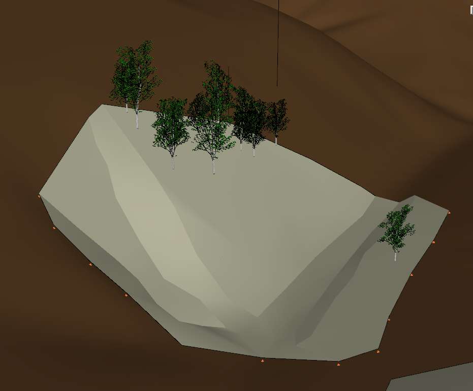
-
Vue9 can import the dxf, dem, ect, then assign material based on slope, height, orientations or even selected with paint brush tool.
Here is a very fast example.
-
@bjornkn said:
Do you really have any choice? Even though DE may do a good job reducing the mes it will not add any detail where there is none. Neither will it use different rules in selected areas (my version doesn't anyway).
Have you actually tried the GP/Triangulate method? It is actually quite fast, and allows you to add detail exactly where you need it, and it allows you to add some edges/creases where there are only ssoft dunes in the dxf mesh.
Like on this little 100 faces patch elevated 50cm to make it visible entirely above the ground. 5mins?What is GP?
-
@solo said:
Vue9 can import the dxf, dem, ect, then assign material based on slope, height, orientations or even selected with paint brush tool.
Here is a very fast example.
I'm a bit confused... So you used Vue to do the reduction shown earlier? I thought you had used Deep Exploration but when I tried a 90% reduction, it it didn't look very good.
-
The earlier one was Deep exploration, the above was Vue, I simply imported the dxf and painted terrain by elevation. No need to reduce as Vue can handle billions of poly's without glitch. However I can reduce in Vue and export to SU if needed.
-
@solo said:
The earlier one was Deep exploration, the above was Vue, I simply imported the dxf and painted terrain by elevation. No need to reduce as Vue can handle billions of poly's without glitch. However I can reduce in Vue and export to SU if needed.
I have Deep Exploration and have tried to replicate the reduction results you achieved earlier but without success. Can you tell me how you did it?
-
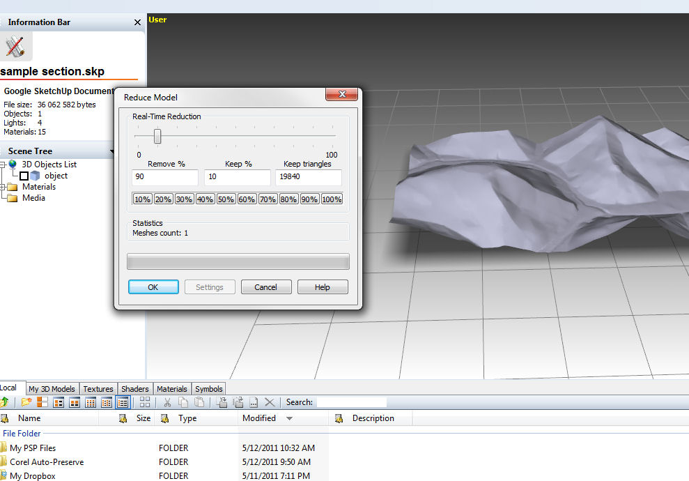
Sure.
Open dxf in SU, then save as SU6 version.
Open it up in DE, and select reduce, process and select 90 percent. Then select heal and save as SU model.That's all.
-
@solo said:
Sure.
Open dxf in SU, then save as SU6 version.
Open it up in DE, and select reduce, process and select 90 percent. Then select heal and save as SU model.That's all.
Oh, I see. So you were only removing 10% of the triangles. No wonder I was having issues, I was clicking 10%, thus removing 90% of the triangles.
-
No, remove 90 percent. see file size from 35MB to 2.6MB
see image:
-
@solo said:
No, remove 90 percent. see file size from 35MB to 2.6MB
see image:
Then there is hope for it still. I am doing the same, or so I thought, but the results are not like yours. I wonder what it could be? My version comes out with strange patches or blotches all over it..
-
Other filtering approaches using MeshLab again but this time doing Vertex Clustering Decimation. SU edges 25625,16900 faces and file size 2599K. The filters it includes are some developers have incorporated in their apps. .Vertex Clustering Decimation.jpg[/attachment]
IMO trying to take this model and editing is not the way to go based on the goal of your OP. To create a virtual tour you must get to the point of selective editing only portions of the map along the lines bjornkn discusses This can be in the decimation or interpolation sense
Next step, layers and selective edits?
-
@mac1 said:
Other filtering approaches using MeshLab again but this time doing Vertex Clustering Decimation. SU edges 25625,16900 faces and file size 2599K. The filters it includes are some developers have incorporated in their apps. .Vertex Clustering Decimation.jpg[/attachment]
IMO trying to take this model and editing is not the way to go based on the goal of your OP. To create a virtual tour you must get to the point of selective editing only portions of the map along the lines bjornkn discusses This can be in the decimation or interpolation sense
Next step, layers and selective edits?Those results look quite promising and seem to retain much of the fine detail.
I completely agree about only editing certain portions along the line. Given the sample I uploaded, a true sense of perspective is lost. Here is a set of 3 meter contours for the entire area involved. I would upload the full resolution version but the file size exceeds the attachment limits. The small patch I uploaded is located near the lower portion of the midpoint. See attachment:
-
Got that in a DEM file? or even .obj, dxf.
-
@solo said:
Got that in a DEM file? or even .obj, dxf.
Yes. I am actually using a DEM file as the source for the sample DXF I uploaded.
-
If you can upload it, or part of it, I'd like to try something with Terragen.
Hello! It looks like you're interested in this conversation, but you don't have an account yet.
Getting fed up of having to scroll through the same posts each visit? When you register for an account, you'll always come back to exactly where you were before, and choose to be notified of new replies (either via email, or push notification). You'll also be able to save bookmarks and upvote posts to show your appreciation to other community members.
With your input, this post could be even better 💗
Register Login


Advertisement