Building a power line
-
First, thanks so much for the quick reply. This is an electric power line that involves 345kV of renewable energy from wind farms in west Texas being transported to the metropolex area of Dallas - Fort Worth. I have found a very similar structure in the component warehouse that matches the pole that will be used. So now I just have to build the line across this vast area. I already know the route that must be taken and it is established in GE.
-
Hi Trent and welcome!
This will be hardly doable in SU. Though what Rich says - you can bring in the GE Terrain (even piece by piece), there will be two great obstacles:
- With such big sizes, SU has serious problems with its OpenGL engine. Even across a couple of miles you will experience serious clipping.
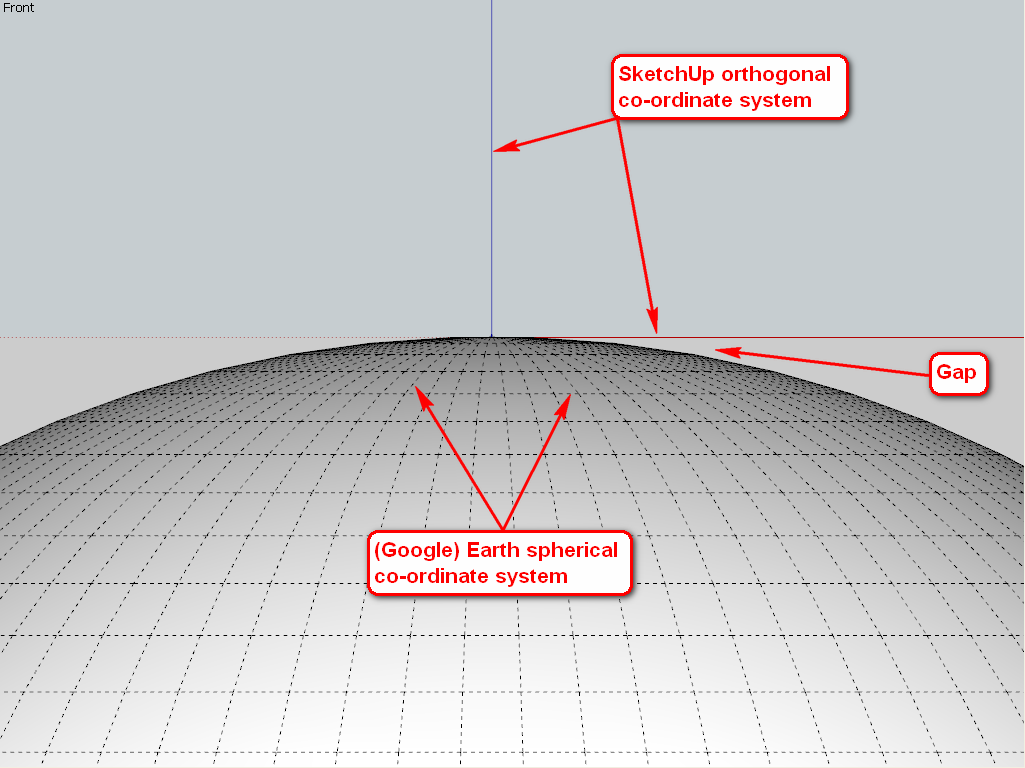
- The co-ordinate system of SU is orthogonal (rectangular) while GE is obviously spherical. Once you are going away from the origin too much, the gap between the two will be more and more apparent and even over a couple of miles you will see your structures hovering in air.
This of course does not cause visible problems with a single (average) city block - for a size the 3D building layer of GE is mainly developed - but your line is absolutely a no-go in a single SU file I am sorry to say.

-
Thanks Gaieus and Rich.
Both very helpful observations and I completely understand the dilemma. I thought I was just lost in not being able to figure out how to tie these poles down to the actual elevation to avoid the hovering you mentioned. It is very obvious especially over the terrain I am dealing with which has up to 200 ft offsets over 1000 linear ft of area. I will seek some other solution for the dilemma, but again thank you both for welcoming me to the forum and I look forward to visiting often as I am a developer at heart and dont always have to work in 100 mile increments!
tp -
I'm just asking because I don't know.
Trent, would you have to end up with a single SketchUp file? If you can drop in pole components (maybe 2 or 3 at a time) on small plots in SU that would then be exported to GE, would that work? Or maybe that would be too time consuming to be worthwhile.
-
Well, Dave beat me but here is a longer answer:
There could be a solution but not from (or not only from) SketchUp itself. That is not a modelling dilemma however (and I cannot give you good advice either).
If you know something about the GE KML API, in the KML fileitself you can efine locations of these poles. If you use SU, the KML file will only refer to one, single origin of the DAE file defining the 3D data and this orthogonal/spehrical problem arises.
Thi is the structure of a typical KMZ file (which is in fact a ZIP file):
-
%(#BF0000)KMZ containing
-
doc.kml - this is what tells about the locations and such and is in xml format.
-
%(#BF0000)models which contains all the models - in case it is an export from a single skp file, only one model no matter if hundreds of miles long
-
untitled.dae (as I did not give it a name thus "untitled") - this is actually your model. One in case of a single SU file exported but why not more?
-
%(#BF0000)files in case there are image materials.
A simple kml file would look like this:
` <?xml version="1.0" encoding="UTF-8" standalone="no" ?>
<kml xmlns="http://www.opengis.net/kml/2.2" xmlns:gx="http://www.google.com/kml/ext/2.2"><Folder>
<name>Untitled</name>
<description>Created with <a href="http://sketchup.google.com">Google SketchUp</a></description>
<visibility>1</visibility>
<LookAt>
<heading>2.834435239173</heading>
<tilt>48.51831414535</tilt>
<latitude>46.08827452512</latitude>
<longitude>18.23550254479</longitude>
<range>567.8324310455</range>
<altitude>376.1211957805</altitude>
</LookAt>
<Folder>
<name>Tour</name>
<Placemark>
<name>Scene 1</name>
<visibility>1</visibility>
<LookAt>
<heading>358.790389084</heading>
<tilt>46.16896337503</tilt>
<latitude>46.08815233808</latitude>
<longitude>18.23557261573</longitude>
<range>11.58149461917</range>
<altitude>27.79851878284</altitude>
</LookAt>
</Placemark>
</Folder>
<Placemark>
<name>Model</name>
<description></description>
<Style id="default"/>
<Model>
<altitudeMode>relativeToGround</altitudeMode>
<Location>
<latitude>46.088276</latitude>
<longitude>18.2355</longitude>
<altitude>0</altitude>
</Location>
<Orientation>
<heading>358.0073992368</heading>
<tilt>0</tilt>
<roll>0</roll>
</Orientation>
<Scale>
<x>1</x>
<y>1</y>
<z>1</z>
</Scale>
<Link>
<href>models/untitled.dae</href>
</Link>
</Model>
</Placemark>
</Folder>
</kml>
Here look at this section:<Placemark>
<name>Model</name>
<description></description>
<Style id="default"/>
<Model>
<altitudeMode>relativeToGround</altitudeMode>
<Location>
<latitude>46.088276</latitude>
<longitude>18.2355</longitude>
<altitude>0</altitude>
</Location>
<Orientation>
<heading>358.0073992368</heading>
<tilt>0</tilt>
<roll>0</roll>
</Orientation>
<Scale>
<x>1</x>
<y>1</y>
<z>1</z>
</Scale>
<Link>
<href>models/untitled.dae</href>
</Link>
</Model>
</Placemark>`
as this is your model. The other placemark above also belongs to here as that defines the camera position when looking at it but that is only necessary for the "tour" element which is not a necessary thing.Now if you had some ways to define the exact location of each pole, you could enter as many placemarks with the exact same model as you wish. Just of course this part has to be changed for each of them:
<Location> <latitude>46.088276</latitude> <longitude>18.2355</longitude> <altitude>0</altitude> </Location>
As the location tag says "relative to grround" and all the positioning below is relative to that place, there would not be any issues with hovering.I hope I was as clear as mud here...

-
-
So, Csaba,
If I understand you, there could be a single SKP model for the pole and then, the text could be edited to make that pole appear at specified lat/lon locations. SO Trent would just need to collect those coordinates and insert them into the snippet of text you have at the bottom. There's probably an easier way to do that than this but I can see how to create the text with a spreadsheet and word processor.
-
Exactly. In fact, there are (should be) ways according to the kml documentation to interactively bring in those spreadsheets but that is already beyond me.
-
Wow! That sounds pretty cool.
Is the model's green axis oriented on the <heading>?
So, for Trent's project the only thing left is the power lines between poles if he needs to show them.
-
Hopefully he doesn't.

-
I agree.
Advertisement


