[Plugin] Display Latitude & Longitude
-
Hi,
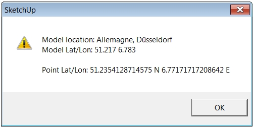
A friend requested this small tool so here it is: assumed your model is georeferenced, click a point and you'll get the latitude/longitude coordinates of this point (decimal format).
Thanks to TIG for helping me on this
Install: drop it in Plugins folder
Usage: Select "Latitude/Longitude of point" from the Tools menu, and pick a point.
French and english versions available on RLD:
http://rhin.crai.archi.fr/RubyLibraryDepot/plugin_details.php?id=737
Regards,
-
Dear Didier,
It would be cool to see you more often
Thank you for this one. I think georeferencement is in the smell of the times. Something which is going to be a sort of revolution. Everybody, everything is going to need to be georeferenced. IMO as a consequency, a revolution in the minds. Like Japanese people we are on to consider that the same object my car for example, is not the same object when it is not at the same place......In case Here is a Motions of the Sun Simulator a tool indicated by Dale
Cheers, simon
-
Didier,
Fantastic plugin. Is there a plugin that you know of that could do the opposite. Insert a point or ray at a known lat long position.
Regards,
Mike -
Hi,
@unknownuser said:
Is there a plugin that you know of that could do the opposite
No, but that's do-able.
-
can you explain how this is do-able or attach a plugin?
-
mike:
SU and Goolge Earth uses the WGS 84 datum ,but not all locales do world wide. So at any time make sure you under stand what datum you need to be working with. -
Didier,
Is it possible to make this extension return the Sea Level ELEVATION, in addition to the Latitude and Longitude, if the model is geo-located?
We often design our sites from land surveys, which provide spot elevations (height above sea level). It would be great to locate those spot elevations on the site in SketchUp as well.
If not, do you know of an extension that can return the geo-located Sea Level Elevation, similar to how your extension returns the Latitude and Longitude?
Hope you can help.
Thanks.
Dave. -
Awesome tool, can you make the text extractable from the dialogue box that is generated so that we don't need to run it through an online extractor?
Thanks again!
-
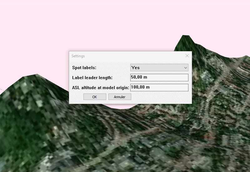
@Mr Mitchell and all,
Here are the french and english versions of the tool.
What's new:
-some parameters, especially the ASL (Above sea level) altitude of the model
- it detects if the model isn't georeferenced
- text in the message box can be copied
- an option to insert text at each spot
- new menu with 2 options: 'settings' and 'Spot Lat/Long/Alt'
See short video below.
Install: unzip the archive, just drop your version of the rbs file in your Plugins folder, restart SketchUp.
Have fun
-
Just for updating the post for Mitchell and Davecoopstl

Hello! It looks like you're interested in this conversation, but you don't have an account yet.
Getting fed up of having to scroll through the same posts each visit? When you register for an account, you'll always come back to exactly where you were before, and choose to be notified of new replies (either via email, or push notification). You'll also be able to save bookmarks and upvote posts to show your appreciation to other community members.
With your input, this post could be even better 💗
Register Login


Advertisement