Cloud V6 ruby
-
Hi,
I am an intermediate user with sketch up. I want to use the Cloud V6 ruby to import a CAD file which has spot elevations so that I can build a TIN. I have louded it into my plug ins but cant find it anywhere in the program. I also dont know how it works..Where can I find instructions on how to use it?
Thanks,
Tenille -
Hi Tenille,
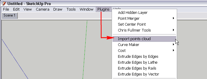
You will first need to export that point data into a simple text file where each line contains only the x,y,z coordinates on one, single point.
Then (if you installed the plugin correctly), you can access it from the plugins menu. Activateing it will prompt for that text file that you need to "feed" it with.
-
how do I export the points into a single text file from CAD? And does the export need to include just the points? So that all the line work would be seperate? Let me know when you can,
Thanks! -
What format is the CAD info ?
A 3D mesh/surface, 3D/2D contours, 3D points, 2D text giving heights etc... there are many ways of using the many different formats of data... please be a little more specific.
You might now even need 'cloud' but another tool...........
-
I have a file in the required format and i have the ruby installed. However, upon clicking OK and selecting the point of origin, nothing happens. Can someone explain this?
Hello! It looks like you're interested in this conversation, but you don't have an account yet.
Getting fed up of having to scroll through the same posts each visit? When you register for an account, you'll always come back to exactly where you were before, and choose to be notified of new replies (either via email, or push notification). You'll also be able to save bookmarks and upvote posts to show your appreciation to other community members.
With your input, this post could be even better 💗
Register Login


Advertisement