sketchucation logo sketchucation
    • Login
    ℹ️ Licensed Extensions | FredoBatch, ElevationProfile, FredoSketch, LayOps, MatSim and Pic2Shape will require license from Sept 1st More Info

    How to insert a skup model into google earth

    Scheduled Pinned Locked Moved Google Earth
    sketchup
    14 Posts 2 Posters 4.0k Views 2 Watching
    Loading More Posts
    • Oldest to Newest
    • Newest to Oldest
    • Most Votes
    Reply
    • Reply as topic
    Log in to reply
    This topic has been deleted. Only users with topic management privileges can see it.
    • GaieusG Offline
      Gaieus
      last edited by

      What if you enable ocean modelling from Preferences > extensions? There IS seabed in the latest GE as well as SU.

      Gai...

      1 Reply Last reply Reply Quote 0
      • N Offline
        nightwhisper
        last edited by

        I need to obtain the coordinate: 44.3140, 9.1750 but in google earth are converted in 46.4000...Is there a kind of convertition?

        Chiara

        1 Reply Last reply Reply Quote 0
        • GaieusG Offline
          Gaieus
          last edited by

          Hm. It doesn't round it for me.


          N44_3140-W9_1750.kmz


          Untitled.skp

          Gai...

          1 Reply Last reply Reply Quote 0
          • N Offline
            nightwhisper
            last edited by

            How did you do to apply the sketchup coordinate to the model?

            1 Reply Last reply Reply Quote 0
            • GaieusG Offline
              Gaieus
              last edited by

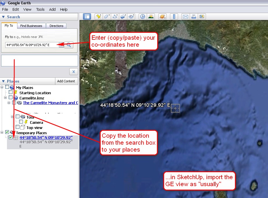
              I entered the coordinates in GE and then imported the GE snapshot as per that tutorial linked above. This will import the exact same geolocation as in GE.

              Gai...

              1 Reply Last reply Reply Quote 0
              • N Offline
                nightwhisper
                last edited by

                Good morning,
                the cordinate are:

                44°18’50.54” N
                09°10’29.92” E

                (44.314038°; 9.174979°)

                And it's a submarine environments...
                How can I obtain the snapshot? 😕

                Chiara

                1 Reply Last reply Reply Quote 0
                • GaieusG Offline
                  Gaieus
                  last edited by

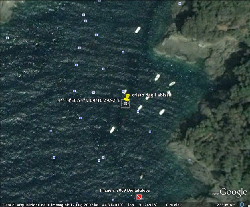
                  Hm. I went west, not east. So it is somewhere in the Ligurian Sea...

                  Anyway, have a look at the screenshot below (kmz file attached)


                  coordinates.jpg


                  Your Submarine.kmz

                  Gai...

                  1 Reply Last reply Reply Quote 0
                  • N Offline
                    nightwhisper
                    last edited by

                    Ok, thanks for all!
                    this is the real image...but I had to import not the image but the seabed of the point... The correct image is the following (I don't know why it is different from your)...but I can't enter into the seabed...why???

                    I'm getting crazy!!!!!!!!!!!


                    temp.jpg

                    1 Reply Last reply Reply Quote 0
                    • GaieusG Offline
                      Gaieus
                      last edited by

                      In GE > View menu, uncheck "Water surface". This will reveal the sea bed. Also, check the Ocean layer in layers.
                      Then in SU, enable ocean modelling (as I suggested above).

                      In fact, I do not precisely know what this will do (we do not have sea here and this is all I found) but it is there for this purpose as a new feature.

                      Gai...

                      1 Reply Last reply Reply Quote 0
                      • N Offline
                        nightwhisper
                        last edited by

                        Is it possible that near the coast is not possible enter into the water?

                        1 Reply Last reply Reply Quote 0
                        • GaieusG Offline
                          Gaieus
                          last edited by

                          I can imagine that the GE sea bed is even more inaccurate as the terrain - so I would think it is possible.

                          Gai...

                          1 Reply Last reply Reply Quote 0
                          • 1 / 1
                          • First post
                            Last post
                          Buy SketchPlus
                          Buy SUbD
                          Buy WrapR
                          Buy eBook
                          Buy Modelur
                          Buy Vertex Tools
                          Buy SketchCuisine
                          Buy FormFonts

                          Advertisement