sketchucation logo sketchucation
    • Login
    ℹ️ Licensed Extensions | FredoBatch, ElevationProfile, FredoSketch, LayOps, MatSim and Pic2Shape will require license from Sept 1st More Info

    High quality satellite images needed

    Scheduled Pinned Locked Moved SketchUp Discussions
    18 Posts 4 Posters 1 Views 4 Watching
    Loading More Posts
    • Oldest to Newest
    • Newest to Oldest
    • Most Votes
    Reply
    • Reply as topic
    Log in to reply
    This topic has been deleted. Only users with topic management privileges can see it.
    • soloS Offline
      solo
      last edited by solo

      Hey guys

      I am desperate for very high resolution/quality satellite maps, I use Placemaker and I also use Nearmap but the resolution is not that great, I have tried using AI to upscale but that too does not really solve my issues.

      Is there another solution?

      I have considered flying out to the location and doing 4k drone images but that cost is just beyond the project as there are 9 different locations over 3 states

      http://www.solos-art.com

      If you see a toilet in your dreams do not use it.

      1 Reply Last reply Reply Quote 0
      • Dave RD Offline
        Dave R
        last edited by

        Does the local GIS service offer hi res aerial imagery? Our county's GIS has offers fairly hi res images on their website. I expect it's possible to purchase even higher res images from them.

        Etaoin Shrdlu

        %

        (THERE'S NO PLACE LIKE)

        G28 X0.0 Y0.0 Z0.0

        M30

        %

        1 Reply Last reply Reply Quote 0
        • soloS Offline
          solo
          last edited by

          I am not versed with this type of solution, is there a tutorial on this? I have once (a long time ago) tried very high-resolution images but struggled to map them to the then Google imagery and terrain I geolocated

          http://www.solos-art.com

          If you see a toilet in your dreams do not use it.

          1 Reply Last reply Reply Quote 0
          • Rich O BrienR Online
            Rich O Brien Moderator
            last edited by

            Check and see if you can hire some in the area to get what you need.

            Wedding photographers have drone services as side hustles this side of the pond.

            Failing that there's https://earthexplorer.usgs.gov/ for height map data and satellite images

            Download the free D'oh Book for SketchUp πŸ“–

            1 Reply Last reply Reply Quote 0
            • Dave RD Offline
              Dave R
              last edited by

              I expect there are tutorials out there although I don't know of any specific ones to point you to. I guess I would start with importing the aerial image as an image and adjust its size. Then create a texture and apply it to the terrain. I'll try to make an example for you.

              Etaoin Shrdlu

              %

              (THERE'S NO PLACE LIKE)

              G28 X0.0 Y0.0 Z0.0

              M30

              %

              1 Reply Last reply Reply Quote 0
              • BoxB Offline
                Box
                last edited by

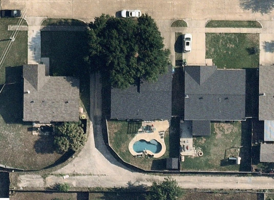
                I zoomed in as best I can


                kisspng-satellite-dish-sputnik-1-l-5ac6f1fa54a2e0.0059052215229875143467.jpg

                1 Reply Last reply Reply Quote 0
                • Dave RD Offline
                  Dave R
                  last edited by

                  Hopefully this will make sense. For this example I'm just using a screenshot grabbed from the county's GIS site. As it turns out, the imagery from Add Location is higher res than the screenshot. On the other hand, the imagery from the website is only a few months old.
                  I used the built in measurement tool to measure a distance on the image.

                  Then I made a screenshot and imported that as an image into SketchUp. I drew a line between the points I previously measured. Then, using the Tape Measure tool, I measured the line clicking at both endpoints. I typed in the distance I measured from the website and pressed Enter to resize the image.

                  I used the Add Location feature to bring in the imagery and terrain. Then I move the imported image to align with the image on the location snapshot. I used the endpoint of a corresponding line drawn on the location snapshot as a guide for placing the image above.

                  I exploded the image (screenshot from the GIS site) so it became a face with a texture. I unlocked the location terrain group, opened it for editing, sampled the screenshot image, and applied it to the terrain.

                  Etaoin Shrdlu

                  %

                  (THERE'S NO PLACE LIKE)

                  G28 X0.0 Y0.0 Z0.0

                  M30

                  %

                  1 Reply Last reply Reply Quote 0
                  • soloS Offline
                    solo
                    last edited by

                    Do you have a link to the GIS site you got the image from?

                    http://www.solos-art.com

                    If you see a toilet in your dreams do not use it.

                    1 Reply Last reply Reply Quote 0
                    • Dave RD Offline
                      Dave R
                      last edited by

                      Here you go. Unless your site is in the county I live in, though, it won't do you a lot of good.

                      Link Preview Image
                      ArcGIS Web Application

                      favicon

                      (gweb01.co.olmsted.mn.us)

                      You should be able to find the GIS site for the county where the site is with a simple Google search.

                      Etaoin Shrdlu

                      %

                      (THERE'S NO PLACE LIKE)

                      G28 X0.0 Y0.0 Z0.0

                      M30

                      %

                      1 Reply Last reply Reply Quote 0
                      • Dave RD Offline
                        Dave R
                        last edited by

                        Example from the GIS site for a county closer to home.
                        Screenshot - 6_28_2023 , 10_50_21 AM.png

                        Etaoin Shrdlu

                        %

                        (THERE'S NO PLACE LIKE)

                        G28 X0.0 Y0.0 Z0.0

                        M30

                        %

                        1 Reply Last reply Reply Quote 0
                        • soloS Offline
                          solo
                          last edited by

                          Thanks, Dave

                          That looks promising, I'll try to look up the counties I need, hopefully I can then figure out the mapping, if only one could get images with terrain

                          http://www.solos-art.com

                          If you see a toilet in your dreams do not use it.

                          1 Reply Last reply Reply Quote 0
                          • Dave RD Offline
                            Dave R
                            last edited by

                            Getting it all in one go would be nice but I expect difficult to find. The county might have topo data in .dxf or .dwg form that you could import into SketchUp. The county that supplied the imagery for that last image I posted has topo lines in one foot intervals. I'd expect you could get the CAD file for them and use that in SketchUp.

                            Etaoin Shrdlu

                            %

                            (THERE'S NO PLACE LIKE)

                            G28 X0.0 Y0.0 Z0.0

                            M30

                            %

                            1 Reply Last reply Reply Quote 0
                            • soloS Offline
                              solo
                              last edited by

                              Dave

                              I am an absolute plonker, to the life if me I cannot figure this out, I cannot get a satellite view like yours above

                              Can you please show me how?
                              Here is one of the locations (there are 3 in total in the same county)
                              I just need to understand one to be able to carry on

                              Attached is a kmz

                              Thanks in advance (only if you have the time)

                              [attachment=0:rpjcdryq]<!-- ia0 -->Sunset Parkway & Novato Boulevard, Novato, CA.kmz<!-- ia0 -->[/attachment:rpjcdryq]


                              Sunset Parkway & Novato Boulevard, Novato, CA.kmz

                              http://www.solos-art.com

                              If you see a toilet in your dreams do not use it.

                              1 Reply Last reply Reply Quote 0
                              • Dave RD Offline
                                Dave R
                                last edited by

                                Go to this website and navigate to the area where the site is.
                                https://www.marinmap.org/Html5Viewer/Index.html?viewer=smmdataviewer

                                On the upper left of the map click on the I Want To button. Then at the bottom of the left hand panel choose Layers. Turn off the layers for stuff you don't need and turn on the Aerial Photography layer. It should look something like this.
                                Screenshot - 6_28_2023 , 1_59_29 PM.png

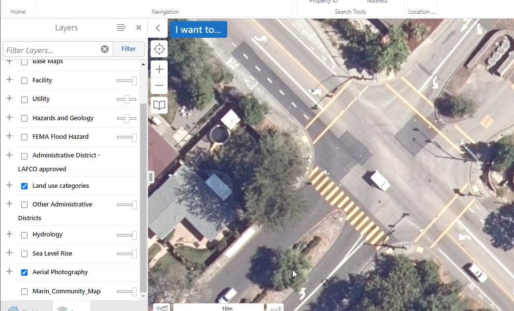
                                I expect the Marin County GIS office would gladly sell you higher res imagery if you want.

                                Etaoin Shrdlu

                                %

                                (THERE'S NO PLACE LIKE)

                                G28 X0.0 Y0.0 Z0.0

                                M30

                                %

                                1 Reply Last reply Reply Quote 0
                                • soloS Offline
                                  solo
                                  last edited by

                                  Thank you

                                  I may need to get hold of them for higher resolutions as this is about the same as Nearmap (at least now I do not have to keep paying Nearmap for something I can get free)

                                  http://www.solos-art.com

                                  If you see a toilet in your dreams do not use it.

                                  1 Reply Last reply Reply Quote 0
                                  • Dave RD Offline
                                    Dave R
                                    last edited by

                                    You're welcome.

                                    What version of SketchUp are you using? I looked at that same intersection with the Add Location feature in SketchUp 2023 and it was very similar to the image suplied by Marin County on their site.

                                    Etaoin Shrdlu

                                    %

                                    (THERE'S NO PLACE LIKE)

                                    G28 X0.0 Y0.0 Z0.0

                                    M30

                                    %

                                    1 Reply Last reply Reply Quote 0
                                    • soloS Offline
                                      solo
                                      last edited by

                                      2018 πŸ˜’

                                      http://www.solos-art.com

                                      If you see a toilet in your dreams do not use it.

                                      1 Reply Last reply Reply Quote 0
                                      • Dave RD Offline
                                        Dave R
                                        last edited by

                                        Ah.... So no imagery with Add Location?

                                        If you're contacting Marin County for imagery you might ask about contour in some CAD format you can import.

                                        Etaoin Shrdlu

                                        %

                                        (THERE'S NO PLACE LIKE)

                                        G28 X0.0 Y0.0 Z0.0

                                        M30

                                        %

                                        1 Reply Last reply Reply Quote 0
                                        • 1 / 1
                                        • First post
                                          Last post
                                        Buy SketchPlus
                                        Buy SUbD
                                        Buy WrapR
                                        Buy eBook
                                        Buy Modelur
                                        Buy Vertex Tools
                                        Buy SketchCuisine
                                        Buy FormFonts

                                        Advertisement