[Plugin] AreaTextTag
-
Well, thanks. I read your top notes, if that's what you mean (and the rest though less carefully). I see nothing about my question but don't doubt I may be missing it still.
Trying your instruction doesn't work for me. Please see this pic:

-
It's not so clear from your image what it is you are trying to tag...
If the boundary edges between two faces are 'smoothed' [and not visible] then the picked/selected area-tag reports the area of the 'surface' - i.e. the two combined faces - otherwise each face gets an individual area-tag.
If you want to show an area split into 'parcels' provided that the dividing lines don't split the face then the area-tag will refer to the underlying face. To stop the face splitting you could either leave a small gap in the line so there is no loop and therefore the face isn't split, or you could use a group to separate the 'dividing' lines from the face so that whilst the face might look like it was divided up it is not, OR draw two sets of faces - one set sub-divided and tagged individually and the other made as a copied group of faces on its own layer with dividing lines removed so there is one face to take the 'combined' tag... Also if you know the total area of a group of plots [found from a temporary outline say] you could add that to each tag's suffix - e.g. "Plot 1 <>\nof 12.3acres", "Plot 2 <>\nof 12.3acres" etc where each <> will contain the actual area, then if you adjust the dividing lines between plots an auto-recalc will adjust each plot's area but display the total consistently ?
You can export a CSV file listing areas-tags and any text you might associate with the area-tags to help identify them. The total is easily got for the area-tags in a column...
-
Thank you. My problem was with the 'visibility off', by which you were not referring to hidden or not as I had assumed, but rather to smoothing aspects.
Work-arounds are easy enough.
To clarify what I'm trying to tag:

-
If it's a single face it gets one area-tag - delete the intervening edges if it's all coplanar.
If it's a single surface that's not coplanar you must 'smooth' the common edges between faces [not just 'hide' them] - i.e. with view>hidden-geometry 'on' use Erase+Ctrl. Then with view>hidden-geometry 'off' place an area-tag on one of the surface's faces - now it'll report the 'surface area' - i.e. the combined areas of all of the connected faces... -
Thank you for such a useful plugin, TIG.
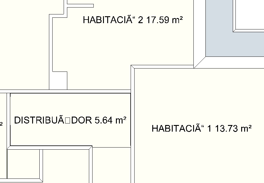
I am having some trouble with accents though, take a look at the screenshot, it should read "HABITACIÓ 1 ..." "HABITACIÓ 2..." and "DISTRIBUÏDOR". Should I change any setting to adjust the text language or character set?
-
If you use those accented characters in 'plain' Text does it then work OK ?
The tool should simply concatenate the same text/areas into one string...

-
Do you mean creating a text label through Tools > Text? If so then yes, accents are displayed just fine.
-
Here's v1.4 http://forums.sketchucation.com/viewtopic.php?p=373717#p373717
The correct interpretation of UTF8 accented characters etc in customized area-tags has now been resolved.

-
OK...
You have the area-tags inside a locked-group.
It [should***] only reports on tags in the active_context.
So unlocking the group and editing it should then produce the CSV...
***BUT it fails - I am investigating why...
If I explode the group the area-tags export OK, BUT I notice the Unicode accented-character errors recurring - so I'll fix that at the same time...
Watch for an update soon... -
Hi again,
I noticed the behaviour you described and was about to post about it when I saw your comment.
One more thing about the exported cvs file if I may: as you can see I am using the following structure for the labels: label name, a new line and the area. The exported cvs outputs exactly this, in the form of "LABEL NAME\n<>", which does not seem very clean. What I can do is run a "find and replace" operation for "\n<>" in LibreOffice and delete it, but imo it would be cleaner if that information was not in the cvs exported file.Thanks for looking into this.
-
@tig said:
Here's v1.4 http://forums.sketchucation.com/viewtopic.php?p=373717#p373717
The correct interpretation of UTF8 accented characters etc in customized area-tags has now been resolved.
Wow, that was quick and effective. Now it works beautifully, thanks a lot!
I am having some trouble exporting to cvs though, the only contents of the exported file is "LAYER,TEXT,PERIM,AREA,UNITS". Perhaps I am doing something wrong, but I think I have followed the instructions properly (save as and then export to cvs). I am attaching you the skp file used in my tests.
-
Here's v1.5 http://forums.sketchucation.com/viewtopic.php?p=373717#p373717
The CSV reporting is fixed - it now uses correctly accented UTF8 characters, and now reports Tags in the active context properly [so if they are inside a group edit that group before running the reporter].
It now also strips all '\n' from reported 'names'
It substitutes '/' if there is multi-line text, other than 'name\n<>' which becomes 'name' anyway, whereas 'name\nmore\n<>' becomes 'name / more' in the reported name.
If the name includes text other than '<>' then the '<>' is always omitted - so 'name <>' becomes 'name '.
However, a Tag with just a '<>' [or '<->'] is still reported as named '<>'. -
I just tested it and works perfectly, I wish I had a hat to take of to you. Thank you so much!
-
Dear Tig:
good job!The CSV reporting is my want,Very slow when reporting ....
-
Its 'slowness' is because it must find all text-tags in the current context by sifting out other things, then it must 'update' them in case a tagged face has changed since the last update, it also must check for tags that are no longer glued to a face and ignore them, and also for duplicate tags placed on the same face and so on [this can be done beforehand using 'Update' manually, which might speed up the CSV a little]... the writing of the CSV file itself is relatively quick once the updating concludes...

I noticed that your CSV toolbar button icon is missing - I have missed it out of the subfolder set.
I'll add it to any future updates, but meanwhile if you substitute/add these two PNG files into the tool's subfolder it will fix the missing icon...


-
Dear Tig:
Here amount only:1001006=60000;slow !!Half an hour past it no finish!
if csv change to xml ?
or other way ?Thanks again !
-
OK!
Irrespective !
I only look forward to it change to very very quickly !Your job is great for all SU-FANS,I love you !
THANKS AGAIN
-
TIG, Many thanks for developing this.
I have just downloaded the RBZ and have tried a few variations of tagging but keep getting zero perimeters. The areas are working as expected with simple rectangles and no grouping. Bug or have I missed something?
Update: If I change "Report Surface Area" to Yes then perimeter is reported.
-
@arcad-uk said:
TIG, Many thanks for developing this.
I have just downloaded the RBZ and have tried a few variations of tagging but keep getting zero perimeters. The areas are working as expected with simple rectangles and no grouping. Bug or have I missed something?
Update: If I change "Report Surface Area" to Yes then perimeter is reported.
You must apply an area tag directly onto a face.... how the hell is it going to know what face to use if you apply it onto a group or instance ?
So... in the same [edit] context as the face you want to tag pick that face to add an area tag onto it.
If you later export those tags from that context into a CSV file the faces' areas and the faces' perimeters are returned...
The 'surface'=Yes tag is intended for adding area-tags to bound-faces that are 'facets' with hidden/smoothed edges, forming a 'surface' where you want the one area reported for all of them together, getting the perimeter of a 'surface' is much more complex than with a face [in fact it's too complex!]... -
Hi TIG, as per my update I was advising that with "surface" = No then the perimeter is not exported to the CSV which is what I was expecting. I now understand your reasoning and will default to "surface" = Yes.
Just a suggestion, reporting the perimeter in both modes may be more logical to the end user, but you know better than most what can be achieved with the coding.
Thanks again for another great contribution!
Hello! It looks like you're interested in this conversation, but you don't have an account yet.
Getting fed up of having to scroll through the same posts each visit? When you register for an account, you'll always come back to exactly where you were before, and choose to be notified of new replies (either via email, or push notification). You'll also be able to save bookmarks and upvote posts to show your appreciation to other community members.
With your input, this post could be even better 💗
Register Login


Advertisement