[Plugin] Heightmap from model
-
This is a great plugin!
I'd love to be able to customize this code for use with a project I am working on. Any chance you will be releasing the code?
Things that would GREATLY help my project include:
- Making Black a background color
- Making square output images (my heightmap importer only accepts square images.)
- The ability to scale the output images to any size I need.
-
really impressive plugin, very nice for render purposes!
But could it be possible to enable it also in perspective view so we could have a depth map for postprocessing a sketchupview?
anyway, thank you very much for this plugin didier!
-
This is indeed very useful for rendering purposes
 -- I would second the idea that being able to generate the image at whatever resolution needed would be great.
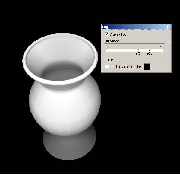
In regards to the previous post, you can do a quick version of what you want using fog:

Best,
Jason. -
Interesting way jason_maranto, thanks for that, will try it!
-
Hey Didier! Trying to get google terrain into UDK and tought this plugin was just what i needed. Got a problem though.
First off, 18700016 rays to shoot? Thats a bit much, why does that number get so large? The model is just a small section of terrain.
After the export when i open the raw file in Photoshop it does not show up as heightmap, but more like a grey mess.Any suggestions? I've got the plane version of sketchup pro and your plugin is the only one installed. Do i need additional plugins installed or something?
Pardon my noobiness!
Cheers!
-
Hi Hanstania,
What this plugin does is the inverse of thomthom's 'Bitmap to mesh' here: http://forums.sketchucation.com/viewtopic.php?t=31339
As you can see a heightmap is a grey scale image so you'll get a greyscale image with my plugin. The size (in pixels) of this image is basically the size of your SU viewport. 18700016 rays to shoot is the result of width_of_your viewport * height_of_your viewport. For instance, a 1024*768 viewport will give 786432 rays and 786432 pixels in the calculated heightmap.
You can resize down your viewport or lower your screen resolution to get smaller (but less accurate) images.
Ensure to 'zoom-extents' your terrain in a top-down orthographic view before launching the script.
You don't need to install anything else that the script.
Please post an example of the 'grey mess' you got
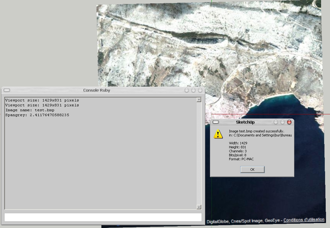
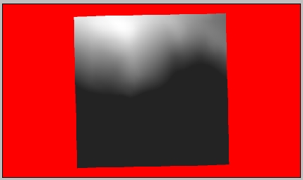
Below are 2 images of a GE captured terrain (mountain and sea) and the resulting heightmap on a red mask. It took 6 minutes to process.


-
I got it to work properly. I wasn't paying enough attention to formats/image sizes and what not. Oops.
Thanks anyway Didier and thanks alot for this plugin, it's been extremely helpful when recreating realworld locations.
-
@didier bur said:
Hi all,
After a long silence, here is another toy I wrote to export SU terrains to Unity3D game engine, which uses RAW heightmaps to create terrains. I thought it could be of any interest to others, so here it is.
Features:- creates BMP or RAW images, greyscale or color, 8 bits or 16 bits from any view of your model (top view recommanded of course)
- creates a colored mask where no faces found in the view
- can crop the image to the model projection
- can blur the heightmap before writing it.
Extract in Plugins folder, PDF doc included.
Regards,
EDIT: new release May 5th 2010, instant bugsplat fix

hi, i'm using heightmap from model plugin, and have got the heightmap. but i don't know the minimum and maximum elevation of the mode. Does the plugin provide these values? Without these values i can't generate a accurate terrain in other 3D software.
-
If you know the over all height of the data in the height-map... you can Import it, then Select the imported mesh and Scale it vertically, typing in the known height WITH A UNITS SUFFIX - e.g. if it's 25m high type 25
**m**+enter and instead of scaling x25 it will rescale so the total height is 25m...
Done
-
Hi,
Before using the tool, open the Ruby console and type:Sketchup.active_model.bounds.min.z (Enter) Sketchup.active_model.bounds.max.z (Enter)This will output the minimum and maximum altitudes in your model (in inches).
Hope this helps, -
@didier bur said:
Hi,
Before using the tool, open the Ruby console and type:Sketchup.active_model.bounds.min.z (Enter) > Sketchup.active_model.bounds.max.z (Enter)This will output the minimum and maximum altitudes in your model (in inches).
Hope this helps,Thank you very much.
I have got some code and made a .rb file by myself,
it can label the min and max elevation value (in current unit setting)
Anyway, thanks again for your reply. -
really need that.
-
 Tips to unpack it :
[mod=Respect the original author:1hft24br]Please respect the author's wish to not have the code visible. Just because a plugin is free doesn't mean the source code is.[/mod:1hft24br]
 You can use the scrambler to protect your code:
http://www.sketchup.com/intl/en/developer/docs/utilities -
NOt working in SU 2014. Its in plugins folder, no crashing on startup, but there is no plugin menu option for this script, any idea ?
thx
-
Hey Didier Bur, Im using the SketchUp Make 2014, and the extensions are .rbz(Ruby) files, so I could not install your extension .rb, and i tried to add a "z" at the end as well, but it didn't install. So I was wondering if you could write a new version for this 2014 build ?
-
@cooldown said:
Hey Didier Bur, Im using the SketchUp Make 2014, and the extensions are .rbz(Ruby) files, so I could not install your extension .rb, and i tried to add a "z" at the end as well, but it didn't install. So I was wondering if you could write a new version for this 2014 build ?
Although Didier should update this plugin to work in SU2014, your method of installing it is incorrect, too. Changing .rb to .rbz is the wrong way to go. SketchUp still uses .rb as the extension for plugins. The .rbz extension is for packaging and to allow you to install via Install Extension, the Sketchucation Plugin Store, or the Extension Warehouse. Changing the extension of the zip file to .rbz will make it possible to install using Install Extension.
Before you change the extension, though, edit the last line of the rb file as indicated here:
-
@dave r said:
@cooldown said:
Hey Didier Bur, Im using the SketchUp Make 2014, and the extensions are .rbz(Ruby) files, so I could not install your extension .rb, and i tried to add a "z" at the end as well, but it didn't install. So I was wondering if you could write a new version for this 2014 build ?
Although Didier should update this plugin to work in SU2014, your method of installing it is incorrect, too. Changing .rb to .rbz is the wrong way to go. SketchUp still uses .rb as the extension for plugins. The .rbz extension is for packaging and to allow you to install via Install Extension, the Sketchucation Plugin Store, or the Extension Warehouse. Changing the extension of the zip file to .rbz will make it possible to install using Install Extension.
Before you change the extension, though, edit the last line of the rb file as indicated here: http://sketchucation.com/forums/viewtopic.php?f=323%26amp;t=12354%26amp;p=529566%26amp;hilit=unpack#p515316
Dave R, thanks for the reply, I understand what you told me to do, but the link you gave is not opening, could you tell me what to edit on the last line of the code ?
-
I edited Dave's link - it now takes you to my post about that edit fix for many of Didier's packed plugins...
-
Thanks TIG
-
Didier has agreed that I might update some of his scripts in the PluginStore, to make them v2014/2015 compatible...
Please get the latest version from the PluginStore http://sketchucation.com/pluginstore?pln=mesh2HeightMap
Advertisement


