Bing Map Birds Eye View Into SKUP?
-
Does anyone have a method of mixing the plan view & birds eye aerial views from the Bing mapping system to create 3D models? I know this is exactly what the Google Building Maker does with Google Maps, but it isn't available for our corner of Scotland.
I'm needing to create a model of the surrounding area of a building site. As the site is quite flat, I thought this method would be possible with photomatch, but I'm a bit lost on how to proceed.
Thanks to anyone who can help. -
I have tried to use Bing birds eye imagery to get the surrounding context buildings. The perspective from those images is typically skewed and also available from only one angle - it doesn't work out well.
Here are a couple of options to consider:
-
Take a real photo and photoshop your model into it. This is the fastest way to a good looking result. If you really need to get the bird's eye, look for a tall building you can access.
-
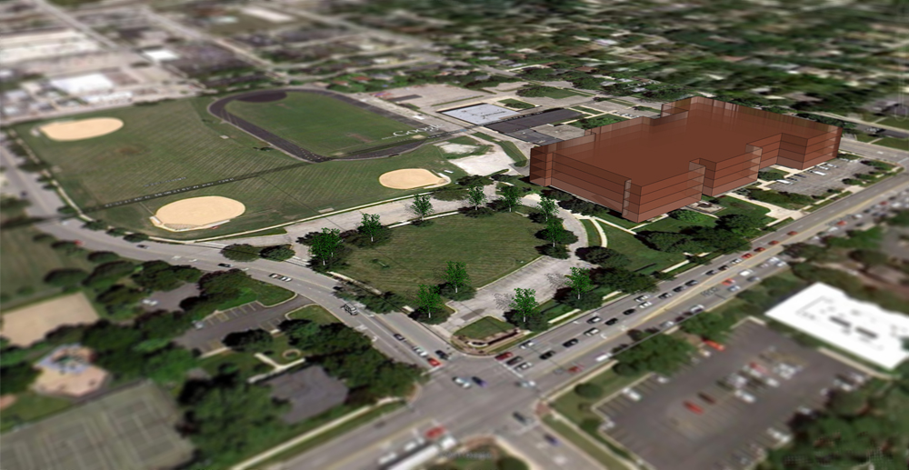
Stitch together google earth imagery to make a base. Than model the surrounding buildings, etc. I attached a quick example to show the effect.
-
-
JGA, I was just looking for a way to do this last week! I have a site where Bing Maps has all four views in axon. I was hoping to use them with some kind of photogrammetry software to construct the context buildings. There are a number of options out there, but none seem to have any information about this particular application. I downloaded, but haven't installed, PhotoSculpt since it has a free trial and doesn't seem to require special camera calibration methods. Awhile back, I remember seeing software that was like photomatch, but for objects: pick points to on a few photos and tell the software which points match between photos. Then it builds the object and will apply the images as textures to each face. The more photos the more accurate. If you find something along these lines, let me know. I often encounter this problem on new projects before we get survey information.
-
Could you share the link to the site with all 4 axons?
Thanks! -
I got the four axon images from Bing Maps.
-
Sorry, got it.
Looks tricky, the images are low resolution and have different exposure and color.
I have heard about people flying lidar, but I don't know of any online sources.
-
Focpt, Ledisnomad,
Thanks for your response & interest.
I tried with the SKUP photomatch tools, but they need an elevation (horizon) to work.
PhotoSculpt - It looks impressive. I just downloaded the trial & gave it a quick whirl, but it appears to need a bit more fettling to get the screen grabs to work. If it works, I'll come back to you.Thanks again.
-
Just a quick update.
PhotoSculpt doesn't like the 90 degree angle between views, but it did process a couple of them. Unfortunately, it took the cloud shadowing as the main difference in levels between the two views & has created a few hills in the flat site!
I haven't tried to import the exported OBJ model into SKUP - it's 187Mb & not practical to work with.Back to the drawing board...
I might try just importing the site plan into SKUP & setting one of the views as a background watermark. I might be able to align the plan with the view & work from there.
Hello! It looks like you're interested in this conversation, but you don't have an account yet.
Getting fed up of having to scroll through the same posts each visit? When you register for an account, you'll always come back to exactly where you were before, and choose to be notified of new replies (either via email, or push notification). You'll also be able to save bookmarks and upvote posts to show your appreciation to other community members.
With your input, this post could be even better 💗
Register Login


Advertisement