[Plugin] [CityGen] - Street Generator [WIP] (0.5.2a)
-
@thomthom said:
Yea, I was thinking of maybe adding a brush painting tool. Where you can sweep. Or maybe have a large hit-radius.
I think that would be a welcome addition to the plugin. I was having frustration issues when I tried to paint lines earlier for my demo too.... They are tricky little things to pin down with the bulky paintbucket.
Chris
-
Yea, I often find that it's easer to select the lines I want to colour and use the Entity info to apply materials. Lines just have too small hit-area.
But I don't see any better way to pre-visualize the road construction. Or any other means of defining road width without it quickly becoming too complicated and bulky. -
We could also offer a way for users to select all boulevards and then pop up a dialog for "assign road widths" and then the plugin does the coloring for the user also.
Chris
-
@chris fullmer said:
We could also offer a way for users to select all boulevards and then pop up a dialog for "assign road widths" and then the plugin does the coloring for the user also.
But how do you define a road as boulevards?
Applying materials to the lines was what I meant to be the method of defining what the road was. The Material name contained the road type name and width, and the colour was the means of providing visual feedback to the user. -
Right, I just meant that they could have all their default black road cenerlines set up. Then they selec the ones they want to be a certain type - lets say they choose all the ones they want to 40m wide. Then they have the option of painting them, or they can pop up a road width assigning window that allows them to enter the width and the color, and the plugin does the width association and the coloring for them.
Its just another method of associating the color and the width to the centerlines. Its not necessary, but I think some might like it?
Chris
-
I'm working on some webdialogs to provide a UI for the read widths.
There would be one that would list the road widths and their associated colour. The default setting would be at the top. You could then select the items on the list to make changes to them. Or create new definition. So when you generate the streets you won't be promted every time. It just uses what you've set up. And if nothing is set up, it uses the defaults. (Defaults would be a setting that's stored between sessions.)
-
I have been adding webdialog support to my inputbox class. Same dialog using UI or WebDialog, persistent storage, array and hash-like access to the values.
I could add it to the repository, if you like it. The plugin page is here.
-
Thanks Jim, but I'm making some illustrations and extra description to go along with the UI elements. So I need to do this by hand. And the Road Type list will require some special UI elements.
But good to know that that plugin class exists. I hadn't noticed it before.
-
thomas,
what if a boulevard had its lanes divided by median strips? how would SG deal with it? and how would one have to introduce the lines before running SG?
-
@edson said:
what if a boulevard had its lanes divided by median strips? how would SG deal with it?
At the moment you'd have to create the lanes as separate streets. Though I'd expect there'd be issues with the rounding as I've yet not made it handle radius' that doesn't fit the space.
I think that median strips would be an advanced feature to add. So when you define custom street types you can specify median strips - I expect that an offset from centre would be useful here in case the lanes are not symmetric. (though asymmetric lines would complicate things...)
-
Test comment.
-
Pushed my work on SG 0.5.1 into the repository. Added a base for webdialogs. I added the jQuery Javascript framework to the project.
I'll make the Street Property editor before I publish the 0.5.x version here. I also want to test it against Mac before 0.5.x goes gold.

-
Looking great Thom! I guess I am going to have to learn me some Javascript now so I can keep up

Chris
-
If you use the jQuery framework you save yourself allot of work. Does much of the nitty gritty boring stuff for you.
I'm also planning to better organize the CSS files. What I'm doing now is that the ui.css in the citygen folder defines the looks of the core UI widgets. For each webdialog I make it's mostly a matter of just defining the correct class to the HTML elements and position them within the window.
-
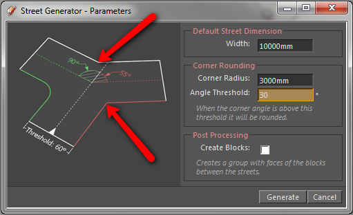
Btw, does the descriptive text and illustration of the Angle Threshold property make sense? You can understand how it works from that?
-
My understanding from the text is that any angle less than 30deg will not be rounded. But the image looks like its showing something different because the green 90deg is rounded, but the red 125deg angle is not. Neither is the white 145deg angle.
So I think I am mis-reading something.
-
@chris fullmer said:
but the red 125deg angle is not. Neither is the white 145deg angle.
Which angles are these? The illustration shows one 90 degrees and one 55.

The idea was to illustrate how it determines what's rounded; with a starting point in the white line with the arrow - coming in from the bottom. The Right edge (Red) breaks of in a 55 degree angle from the white - with a threshold of 60 degrees that means this corner won't be rounded. The left edge (Green) breaks off in a 90 degree angle - above the theshold; so it is rounded.
How can this be better described / illustrated?
-
The angles that are labeled don't correspond to the sidewalk that will or won't be curved. I was thinking the angle threshold would correspond to the angles I am pointing at in the picture. I'm sure I'm just misunderstanding how the script is supposed to work.
Chris
-
I see.
The reason the angles differ, is because I based it off the centre line. You see the Red and Green arc? That's the angles I measure.
I was thinking of the angles as in how much it rotated away from the centre line - like if you'd be driving down the street; how many degrees you'd have to turn.
That's why the red and green radius is located by the centre line instead of the street edge. The colour coding was meant to illustrate which edge corner the angle related to.
Interesting how you had a different approach to it. That's what I was curious of. It'd be good if more people could let me know how they'd expect it to work. What feels more intuitive.
-
Not sure where to post this or even if it's relevent, if anyone wants to be part of this city gen app follow link: http://www.fileplanet.com/promotions/cities-xl/?_cmpid=fp161
Hello! It looks like you're interested in this conversation, but you don't have an account yet.
Getting fed up of having to scroll through the same posts each visit? When you register for an account, you'll always come back to exactly where you were before, and choose to be notified of new replies (either via email, or push notification). You'll also be able to save bookmarks and upvote posts to show your appreciation to other community members.
With your input, this post could be even better 💗
Register Login


Advertisement