sketchucation logo sketchucation
    • Login
    1. Home
    2. JonathanSmithFreemont
    ℹ️ Licensed Extensions | FredoBatch, ElevationProfile, FredoSketch, LayOps, MatSim and Pic2Shape will require license from Sept 1st More Info
    J
    Offline
    • Profile
    • Following 0
    • Followers 0
    • Topics 2
    • Posts 8
    • Groups 1

    JonathanSmithFreemont

    @JonathanSmithFreemont

    10
    Reputation
    1
    Profile views
    8
    Posts
    0
    Followers
    0
    Following
    Joined
    Last Online

    JonathanSmithFreemont Unfollow Follow
    registered-users

    Latest posts made by JonathanSmithFreemont

    • Aligning axis

      Hi there,

      As explained in my other post http://sketchucation.com/forums/viewtopic.php?f=271%26amp;t=60248 , I've imported a google map with height data, and it is of course aligned correctly to the "world corners", as it should be. This way light and shadows will work according to location, season and time of day, which is just perfect.

      However, my house, that I'm modelling, while rectangular, does not align to the real world north/east/west/south axis.

      When I started, I modelled it according to it's true orientation, but consisting of so many groups, components etc. on different layers, I soon found that it was very difficult to get lines, models, components etc. to snap to each other, when rotating, connecting etc. It is so much easier when they can snap/align to the global axises.

      I know that I can set the axis for each component etc., but i find that it is difficult and very time consuming, and anyway, every helper tool, like the tape measurement tool for instance, always seems to be much easier to align to the global axises, than between several groups and components, that have had adjusted their axis.

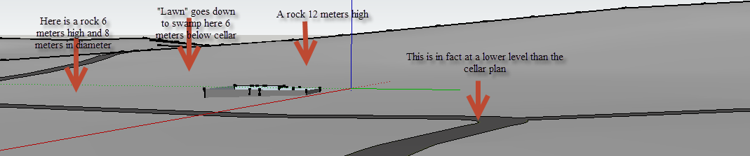
      As a result, I have aligned my house to the global axis, making everything so much faster to work with. But needles to say, this means I get a false image of how the house relates to the landscape.

      Is there a way around this?

      Please ask, if I haven't explained myself well enough, English isn't my native language.

      Best regards,

      Jonathan Smith

      posted in Google Earth sketchup
      J
      JonathanSmithFreemont
    • RE: Refining contour layer created from Google Earth

      Alright, thanks a lot for the swift reply πŸ˜„

      posted in Google Earth
      J
      JonathanSmithFreemont
    • RE: Refining contour layer created from Google Earth

      Hi agian,

      This may be a really stupid questiong, but apart from using the tampe measure tool, isn't there a way to just click on an entity and get its height readings relative to either the 0 on the blue axis, or a set reference point, or meters above the ocean?

      The entity info only shows me the length, which is nice, and I realize that an entitiy that is not horizontal, would require more than just one number, but anyway?

      Kind regards,

      Jonathan Smith

      posted in Google Earth
      J
      JonathanSmithFreemont
    • RE: Refining contour layer created from Google Earth

      Artisan tools and Vertex tools in combination are just brilliant for my purpose. Obviously, I haven't modelled the whole parcel yet, but I've learned (at least a fraction of) the possibilities, which seems to be just what I needed. Thanks a lot for the advice.

      Best regards,

      Jonathan Smith

      posted in Google Earth
      J
      JonathanSmithFreemont
    • RE: Refining contour layer created from Google Earth

      Thanks a lot for your suggestions, both of you.

      Now I did in fact use the sandbox "From Contours" to create the landscape, after creating contour lines from Google earth using the tutorial described in my first post.

      It works fine on the greater area, of which my parcel is just a fraction, but Google Earth doesn't have enough height data within the relatively small parcel, to make correct contours. If for instance Google have one height measurement in one end of the parcel, and another in the other end or even outside it andd so on with a third an fourth, the contour I initially made with "From Contour" in sandbox, will just have face that are almost planar between those points, where in fact there are loads of important details (like the swamp and the rocks (or maybe more corrrectly small rocky hills) in between.

      It is this area that I wish to modify, by adding extra facets in the parcel, to correct the missing height data, while planning to keep the contours in the greater area.

      My problem with the smoove tool is that it will move everything up or down based on a circular selection, while In many places I need to move them up or down based on for instance a rectangular selection of the faces' connection points.

      I've just started tonight examining your advices, and it looks like the Vertex plugin gives me a lot of help here. Curious to try it out πŸ˜„

      Thanks again.

      Kind regards,

      Jonathan Smith

      posted in Google Earth
      J
      JonathanSmithFreemont
    • RE: Refining contour layer created from Google Earth

      Hej pbacot,

      It splits the facets in triangles, but the smoove tool works in circles so say i want to create contours that doesn't follow circles or combinations of them, I find it very hard to make those without making very rough edges. But maybe it's just because I'm a noob πŸ˜„ I'll try experimenting more with that tonight, when work is over (11 a.m where I'm at). Thanks for the input.

      Best regards,

      Jonathan Smith

      posted in Google Earth
      J
      JonathanSmithFreemont
    • RE: Refining contour layer created from Google Earth

      Hi Pbacot,

      Thanks for your suggestion, I'll investigate and try them. Yes there are up to 40 meters between connectionpoints, so there are far to few facets to make any just roghly detailed shaping.

      Best regards,

      Jonathan Smith

      posted in Google Earth
      J
      JonathanSmithFreemont
    • Refining contour layer created from Google Earth

      Hi there,

      I've succesfully imported a 3D map from Google Earth, created contour lines by intersecting the map with a series (hundreds) of horizontal rectangles few feet apart, and made a landscape by using the sandbox "Create from contour lines" as partly described in this tutorial https://www.youtube.com/watch?v=y4J9sWEZR6E.

      Now my problem is that the height data from Google Earth is to coarse. It's fine for the greater area around my parcel (a house in the woods of Sweden), but within the area of my parcel the plane is virtually flat, or goes from one extreme outside the parcel to another outside the parcel, meaning that all the details of the parcel, which measures around 150x150 meters are non-existent.

      The terrain within the parcel is very irregular, with rocks and small "hills" rising to several meters, and the "lawn" not at all horizontal anywhere.

      I tried turning on hidden geometry to try and edit the heights within the parcel, but to no avail. Am I supposed to be able to edit the contour plane this way, also regarding heights? All I seem to be able to do is to add, flip or delete lines.

      Creating a sandbox from scratch to intersect with the contour plane, doesn't really seem to work, because the smove option only allows my to make circular modifications, which doesn't work very well, since it is all too imprecise.

      Any advice would be highly appreciated. See attached example, for better understanding. Those deviations from the contiur plane are only a fraction of those existing.

      Best regards,

      Jonathan Smith


      example.png

      posted in Google Earth sketchup
      J
      JonathanSmithFreemont