Archeology, 3D and photogrammetry?
-
For software, AutoDesks 123D is worth a look
http://www.123dapp.com/catch -
@jga said:
For software, AutoDesks 123D is worth a look
http://www.123dapp.com/catchI just downloaded this and gave it a try. Have you exported to a dwg mesh and tried to import to SU? I tried and SU said it could not open the dwg file.
-
Sorry, never installed it, but it could be a newer version of AutoCAD DWG that SKUP can handle.
-
@gaieus said:
Very true and also somewhat sad. We have a 4th century chapel here on which we had a lot of arguments (how it may have looked like when not in ruins) and actually SU (and 3d) was the way to prove one of the theories. Yet it is still not taken for a way of "research" (or reasoning/proving) but just a "toy" to ply with after the "professionals" have finished their roles.
That was actually what I was afraid of - that it would be regarded as toys - maybe because it doesn't cost thousands or millions of dollars? I believe SketchUp has managed to get that "toy" tag (almost) removed after many years in the architectural business, although there's probably still a lot of skepticism from those who don't believe a program without an Autodesk logo (and a $10000+ tag) on it can be useful.
Too bad those archeologists invovled in this current projects lives 1200kms away
This summer the local (county) archeological authorities will conduct a ground radar survey near a farm where a lot of my family comes from (back to the 1500s though..) There are some stone circles there (neolithic?), and they want to see if there is also something in the ground.
Do you think they would just be annoyed if I offered them to do some photogrammetry 3D "survey" there at the same time? -
I don't know. Also, it is very much up to the person. I know architects here who still do not use computer for designing (although they employ draftsmen to do this). My archaeology professor has got to the point that he understands that digitizing data is important. So he now scans his site drawings. But when I try to explain him what the difference between raster and vector is, he is hopeless. But he regards himself as a modern person because he can send an email (true that he has not been able to update my contact details in his list for ages).
So whet do we expect? Sooner or later, when decision makers in this industry are already from a next generation, things like this will slowly infiltrate.
-
@jga said:
Sorry, never installed it, but it could be a newer version of AutoCAD DWG that SKUP can handle.
Installed it and it is amazingly simple. I was even able to export as object file and import that into SU via TIG's OBJ to SU plugin. Also made an animation but I don't have the right codecs to get the animation working. I dont know as much about UVs as I should so proper texturing is a hang up. Biggest problem is lack of proper documentation.
-
On an archaeology related note. I was baby sitting for my daughter and her husband because they were going to see a Harvard Club presentation called "Mayan Apocalypse 2012: What to pack." It was a serious presentation but the presenter just couldn't resist the title.
-
@gaieus said:
I don't know. Also, it is very much up to the person. I know architects here who still do not use computer for designing (although they employ draftsmen to do this). My archaeology professor has got to the point that he understands that digitizing data is important. So he now scans his site drawings. But when I try to explain him what the difference between raster and vector is, he is hopeless. But he regards himself as a modern person because he can send an email (true that he has not been able to update my contact details in his list for ages).
So whet do we expect? Sooner or later, when decision makers in this industry are already from a next generation, things like this will slowly infiltrate.
It is strange that archeologists seems to jump directly from the "stone age" (tape measures etc) to the space age (very high-tech/cost lasers, ground radars, sonars etc) directly, without absorbing the "landscape" between? Architects went from paper/pen to 2D computer drafting and then 3D.
However, I have now got the dates for that stone ring survey (with magnetometers apparently), and "permission" to come and "look" at them working. Guess I'll bring my cameras and fisheye for 360s, and then we'll see what happens.

11-13 april it is
-
@roger said:
@jga said:
Sorry, never installed it, but it could be a newer version of AutoCAD DWG that SKUP can handle.
Installed it and it is amazingly simple. I was even able to export as object file and import that into SU via TIG's OBJ to SU plugin. Also made an animation but I don't have the right codecs to get the animation working. I dont know as much about UVs as I should so proper texturing is a hang up. Biggest problem is lack of proper documentation.
Does it export to obj without materials/UVs then?
Any example images? -


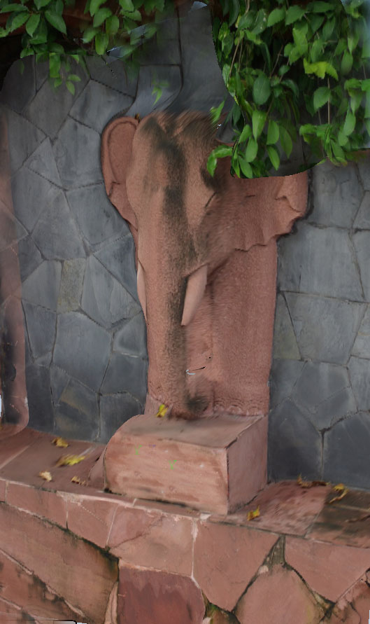
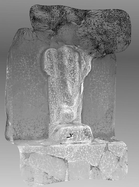
On the left is the mesh and on the right is a random angle of the 3D object.
I am redesigning my house on the fly to get it ready for sale and doing all the craftwork involved so I have not really been able to experiment very deeply. What you see was created from just three photos taken about 50 degrees apart. From what I can see on the web many of these projects might use 30 or 40 photos to avoid ambient occlusion. The mesh you see above is an image display option. The full image has the UVs on the mesh' So far I have not been able to get SU to open the DWG file directly so to get it into SU I have used TIGs OBJ2SU plugin which does not seem to bring the UVs along. It seems like you do not get to own the mesh directly as it may only live on a AutoCAD server out in the cloud.I think the project file only consists of a URL pointing to the autoCAD server. So if you are not online you may not be able to rotate your project in time. This is just one of many things I need to test at this point. However by exporting to OBJ then you can pull the mesh into SU. If it sounds like I am rambling I am a bit sleep deprived. However I am excited by the ease of use and the potential. With synchronized camera you could even still capture a moving object. Give me some time for moving and testing and I promise to show more of my research.
The three original source images were captured at a hotel dock near the flooded Chao Praya River in Central Bangkok in late October, 2011. -
Interesting, but it looks like it shares the problems with automated solutions with other such "autoscanner" tools.
It looks like there is no holes in the mesh, which is surprising.
There is something strange going on with that trunk and tusks though?
I would have been very surprised if it managed to make a great, fully detailed/textured model of that sculpture though, without ears, trunk, tusks etc growing into the background, and with no branches/leaves in front, and leaves on the stone (bench?). Even with a lot of photos.
And what about precision/scale? Is it possible to set any scale/reference measurements?
Looking forward to see more
-
There are 3 levels of detail (mobile device/standard/detailed) The image I showed you was the mobile version. Also more original views help with ambient occlusion and greatly enhances texture detail. I think part of what bothers you is the sculptural technique of molding the tusks to the trunk to make sure physical support is created (IE no thin parts sticking out on their own). If you used multiple radio triggered cameras you could capture a live elephant in quite a bit of detail. As to accuracy of dimensioning I suspect it is quite good where you have hard geometric edges to measure to. Remember, if you import the mesh into SU you will need to scale your object using an actual ground truth measurement manually taken for the actual scene at the time of the photograph. Once you do this all other points in the mesh will scale to the same degree of precision.

I call your attention to the void created by the trunk loop and remind you that in the real object the tusks are molded into the trunk for support. The original (real) object is just decoration and not a highly detailed piece of fine sculpture.Also once imported as a 3D object into SU and then taken to a render engine, shadow which I was avoiding in the capture would be reintroduced enhancing the sense of depth.
-
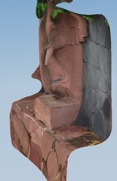
Is the trunk "free" from the background, or is there no "hole" behind it?
It is a bit hard to see on that first photo.
I guess those are screen dumps, as there are photo textures on it? -
There is a hole, albeit a small one, behind the trunk.
-
Ah, so that hole is not a hole in the mesh, but an actual hole then?
-
Related webinar
-

I trimmed some of the foliage and change the angle so you could see how the trunk reconnects to the wall. If time allows I will do more experiments with metrics tomorrow. -
Looks like a relative of Zorro

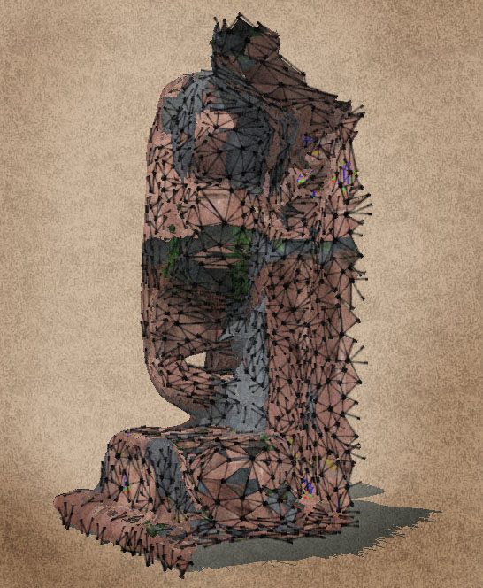
Is it the UV mapping that messes up the texturing?
Strange trunk/model BTW.
Have you also tried other "3D scanners", like http://www.agisoft.ru/products/photoscan/
Or Photomodeler Scanner?So far I really prefer the results that can be had from tgi3D Photoscan

I love the way it combines full control with "shrink-wrapping" meshes.Being in the pockets of Autodesk (or should it be said the other way around?) isn't what I want the most

It is very sad how they have bought most of the 3D competition
Good to know that SketchUp is "safe" now;) -
One example of a virtual tour in an archaeological subject was this Flash movie about Marcus Lucretius's house in Pompeji that was made by Finnish 3D (probably 3D Studio) students in close collaboration with the archaeologists.
Anssi
-
About 10 years ago, we made this with 5 other, Roman sirtes. The "interactivity" is only for some of them but there are stunning videos, too.
Note that 3D rendering as well as screen resolutions and bandwidth was much slower/smaller than nowadays...
Advertisement


