Trying to create surface terrain
-
Hi
I am trying to create a 3D model of an old mine site. I have done a survey with a total station and created a simplified 3D outline model in Autocad which I have imported into SU as a Dxf file. I am now trying to build a model in SU using the Dxf file. I understand I need to use the CAD drawing as a platform from which I draw on top of with Sketch Up. The problem I am having is trying to draw on top of the contour lines with the freehand tool, are there are any tips to help with this. The contour lines are made up of tiny segments so cannot be selected as contours using the Sandbox tool. Any advice how to successfully trace the contour lines with SU?
Many thanks
-
I create dxf contour lines by drawing over a topo image in Illustrator with the pen tool.
You can then modify each path and reduce the number of vertices until you get the poly count as low as you desire. Export from Illustrator as a dxf, import into SU, pull each path to the correct elevation, and use the sandbox to create a TIN from the contours, and you are off and running.
I have used SU for 6 years and have never used the freehand tool, fwiw.
For a solution that is all SU, you can import the topo image and use the bezier curve plugin from Fredo to trace over the lines. His plugin has options for controlling the number of vertices, too. I just find that Illustrator works better and quicker.
-
This is how I often make quick terrains from detailed contour lines.
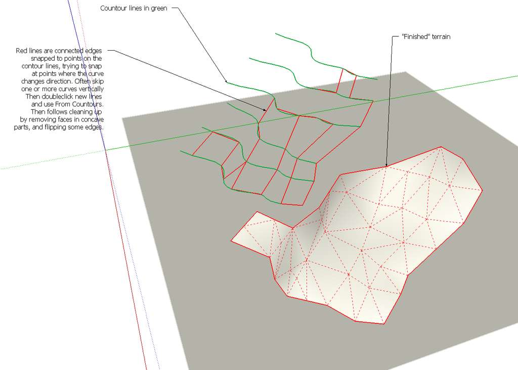
-
I have been dealing with a similar kind of project, so maybe these comments help you. I had a pdf document with all the contour lines. Actually some really helpful people in this forum helped me to convert the pdf into skp file (pdf => dxf => skp). Anyway, if you don't have these softwares I have found that the best way is to trace the contour lines form image file of the terrain/contours. Workflow would be:
- Import the image file and scale it to the right size
- Trace the contour lines with Catmull Spline - tool (bezierspline plugin) and using top view
- Put all the contours on certain layer that corresponds the height value (contour height 20m => layer: 20m)
- Use Edge tools or simplify contours plugins to simplify the contours if needed
- Use front/back view and use the move tool to put the contour lines to certain height
- Use Sandbox tool to create the terrain
Anyway, I don't know detailed you need to be and how big is the terrain. This is the map of the project that I have been dealing with.

Hello! It looks like you're interested in this conversation, but you don't have an account yet.
Getting fed up of having to scroll through the same posts each visit? When you register for an account, you'll always come back to exactly where you were before, and choose to be notified of new replies (either via email, or push notification). You'll also be able to save bookmarks and upvote posts to show your appreciation to other community members.
With your input, this post could be even better 💗
Register Login


Advertisement