What have I done wrong
-
Newbuyer
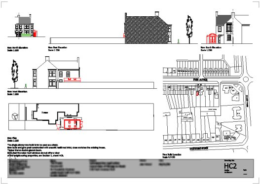
Are you in the UK? I'm guessing you are as you refer to "building regs". A big part of my job is planning applications. You can definately do all the drawing in SU, the level of annotation needed though is a tall order for Layout. It can be done, but if you use a cad program that has a layout function it might be easier. You can import all the views from SU as dwg files. You could try Progecad-Smart it's free. See example.

-
Hi linea,
Yes, I am in the UK. It was only my intention to get outline permission - not to do the second part myself.
The only info I found was on this sitehttp://www.diydata.com/planning/planning/planning_drawings.php
Hope I'm not breaking any forums rules posting that. I'm hoping that I can do drawings to the same level as the examples on this using sketchup. My plan is to do what I can then get the council to look over them and let me know what further detail is required. I'm hoping it will be enough.
If you have any further info on requirements for outline planning permission then I'd be very grateful/interested. Thanks for suggesting that package. I'll no doubt look at it at some point but after doing battle with sketchup for a few days I'm hoping I don't need to learn another new package!
Gaieus,
Thanks again for your continued input. I'd even seen a tutorial video on that and clean forgot about it! Just so much to learn I can only take so much in. -
@unknownuser said:
I'm hoping that I can do drawings ... using sketchup. My plan is to do what I can then get the council to look over them and let me know what further detail is required. I'm hoping it will be enough.
Yes that is a good start. You do need to provide them with a location plan though - thisis the ordnance survey street plan of where the property is. The first option would be to buy one as a jpeg from the UK government planning portal for £19.95 or if you want one that you can import as lines in Sketchup, you can buy a dxf version from Blackwells, to get a decent sized area normally costs around £45. Ordnance survey is a rip off! The free option is to really carefully trace over a google earth import in SU or cad and mark on the surrounding house numbers and street names. I have done this a few times, the results have been accepted by planning but it can be more hassle than its worth so I usually buy them.
The planning portal is the best resorce for you but if you need any help let me know.
http://www.planningportal.gov.uk/england/genpub/en/1115315884635.html
http://maps.blackwell.co.uk/lsm/bmo.html -
Hi,
Thanks again. I have two O/S type location plans of 1:500 and 1:2500 on hard copy. I am fortunate to work for a utilities company with access to GIS data.
However, I'm not going to be able to import them into any CAD packages. From that website I was under the impression they were just standalone requirements.Next door is a straight wall so I was just going to measure the distance from our property and draw it onto sketchup to show proximity.
I'd appreciate feedback if you think that will work? I know I should run it by the council but thought it easier to draw something for them to look at first, rather than trying to explain all this over the phone. As I said, I'm confident (well hopeful anyway) I can meet the requirements on that other forum with Sketchup.
Thanks again to all who have helped me on this - never expected even half as much helpful advice as I've recieved.
-
Yes always best to draw up something to show the council first and yes it is fine to supply the o.s. map on a different sheet, just mark in red pen where the development is.
-
@newbuyer17 said:
...I am fortunate to work for a utilities company with access to GIS data...
You should be able to export dxf content from GIS (at least AFAIK - that's how I have all the siteplan of my home town from the council I currently work for)
-
I will make some enquiries. I dont work with the system myself, I just asked someone (who I dont even know) to do me a favour and print them off for me. If I need electronic copies I'll see if I can get them exported.
-
Gaieus,
Have managed to recreate what you did all except@unknownuser said:
Then I reversed all back (blue) faces.
Could you please explain this step to me. Is it a global setting, or are you colouring each individual face?
Thanks
-
In su all faces have front and back faces: if you draw a rectangle you will see one face is blue and the other white. White is the front face, blue is the back face. You can reverse the direction of the face by right clicking it->reverse face.
-
Or when you have bunch of back faces, you can select them all (Shift + select = toggle selecion, Ctrl + Select = add to selection, Shift + Ctrl + Select = Deselect) then right click on any of the selected faces and do the reverse operation per Remus' method above.
If you have a neatly and cleanly made model and it's not too complex yet, right clicking on a front face and choosing "Orient faces" may work as well since it should turn all back faces to front faces. There are a lot of factors that influence this however and often unwanted results may occur.
Advertisement


